
*****Major snowstorm for many in the eastern Mid-Atlantic region including SE PA, NJ, DE, and NYC…significant snowfall…strong winds…possible "thundersnow"...a long duration event*****
Paul Dorian
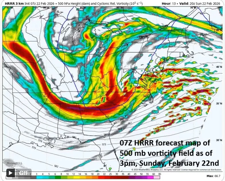
The upper air pattern features plenty of “vorticity” and will be conducive for rapid intensification of low pressure by later tonight just off the Mid-Atlantic coastline. The low pressure system will not only become very strong, but will be a slow mover making for a long duration event in the Mid-Atlantic region. Map courtesy NOAA, Weather Bell Analytics
Overview
The Blizzard of 2026…
What may become known as the “Blizzard of 2026” to some in the eastern Mid-Atlantic region begins rather innocuously this morning with plain rain and above freezing temperatures in some areas and a mixture of rain and snow is likely soon in other locations. However, precipitation will change over to all snow by later in the day in most areas, become heavy at times early tonight, and continue into mid-day Monday – a long duration event. In fact, the snow could fall heavy enough tonight in the eastern Mid-Atlantic region to produce 2+ inches per hour and “thundersnow” is on the table. Snowfall amounts in the eastern Mid-Atlantic will become significant with a foot or more in many areas. The DC metro region will escape the significant snowfall amounts coming to the eastern Mid-Atlantic, but at least a few inches are on the table in the nation’s capital. Winds will become a big factor by later tonight and continue strong on Monday resulting in blowing and drifting of snow during the latter stages of the storm. On the heels of the storm, a very cold air mass will flood the eastern US for the first half of the new week.

There will be an area with tremendous upward motion (shown purple) during the nighttime hours in a region with strong 700 mb “frontogenesis”. In this area of the eastern Mid-Atlantic, snow can fall at 2+ inches per hour and “thundersnow” is a possibility during the nighttime and on Monday morning. Map courtesy NOAA, tropicatidbits.com
Details
Precipitation is expanding in coverage this morning in the Mid-Atlantic region as low pressure strengthens near the Carolina coastline. Some areas in the I-95 corridor have begun the day with plain rain and other areas will soon see a mixture of rain and snow during the initial stage of the storm. All areas should see a changeover to snow later today, and the snow will fall heavily at times from Sunday evening to Monday mid-day, leading to big-time travel disruptions for the Monday commutes. In fact, the snow can fall very heavily tonight with rates of 2+ inches per hour across portions of southeastern PA, NJ, DE and NYC and “thundersnow” is even a possibility in some of these areas.
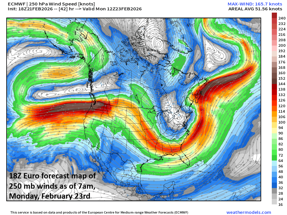
A strong jet streak in the upper part of the atmosphere will support rapid intensification of low pressure later today and tonight just off the Mid-Atlantic coastline. Map courtesy NOAA, weathermodels.com
Significant snowfall amounts are likely in much of the eastern Mid-Atlantic region by mid-day Monday and winds will become a big factor as well with gusts to 45 mph across inland areas and up to 55 mph or so along coastal sections from Long Island to New Jersey to the Delmarva Peninsula…all-out blizzard conditions in some areas with blowing and drifting of snow in the latter stages of the storm.
The snow will fall very heavily tonight and can exceed 2 inches per hour in some parts of the eastern Mid-Atlantic region with “thundersnow” on the table. Map courtesy NOAA
Here is my latest thinking on snowfall amounts in the following areas:
DC metro: 4-8 inches
Philly metro: 10-20 inches
(higher amounts in the range on the eastern side e.g., Bucks County, and the lower amounts in the range to the west e.g., western Chester County)
NYC metro: 1-2 feet (isolated higher amounts)
New Jersey: 1-2 feet (isolated higher amounts)
Delaware: 10-20 inches (isolated higher amounts)
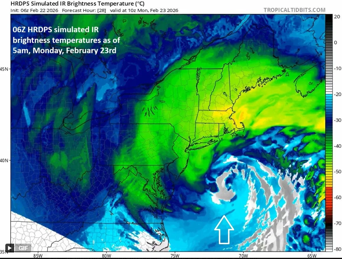
The low pressure system during this upcoming event will become powerful and an “eye-like” feature (above the arrow) may form at its center similar in appearance to hurricanes and not uncommon for some of the great nor’easters. Map courtesy NOAA, tropicaltidbits.com
The snow will be of the “heavy, wet variety” until late in the event with surfaces temperatures not all that far below freezing in most areas. Heavy, wet snow is not a good thing as it adds to the weight on rooftops, tree limbs and is very difficult to shovel…power outages are a concern; especially, in blizzard prone areas of the eastern Mid-Atlantic where winds can gust past 50 mph. One other note, widespread coastal flooding is on the table during Sunday night’s high tide cycle and those issues can continue on Monday as well.
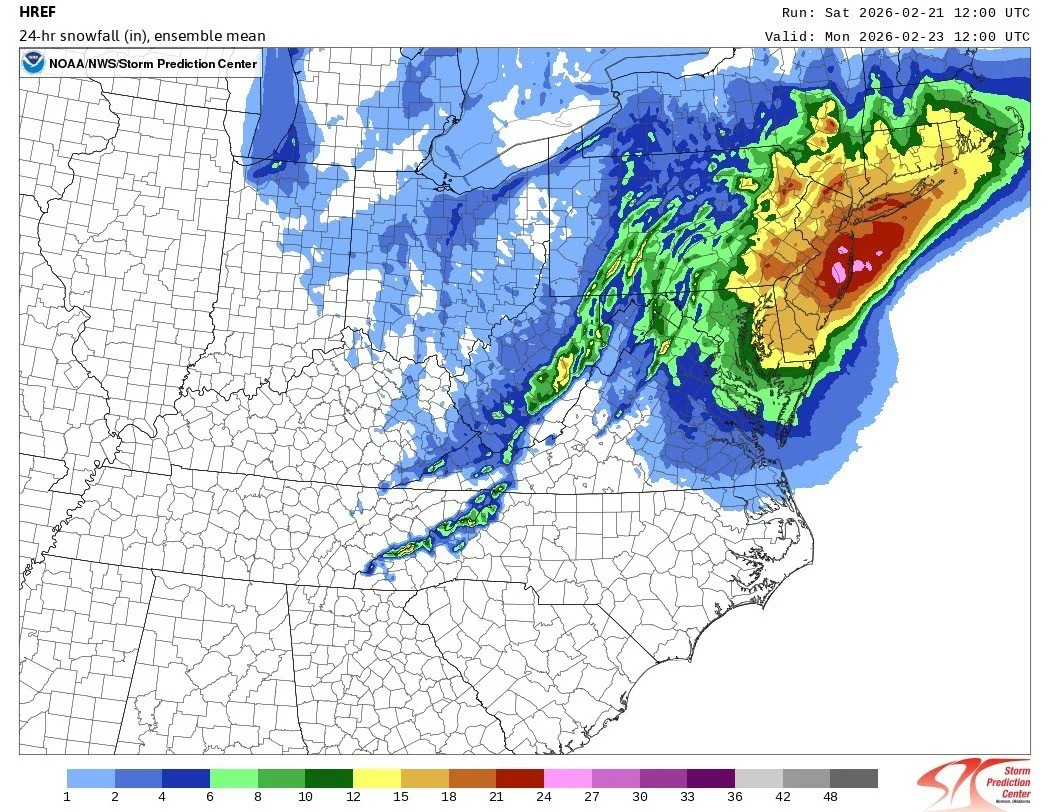
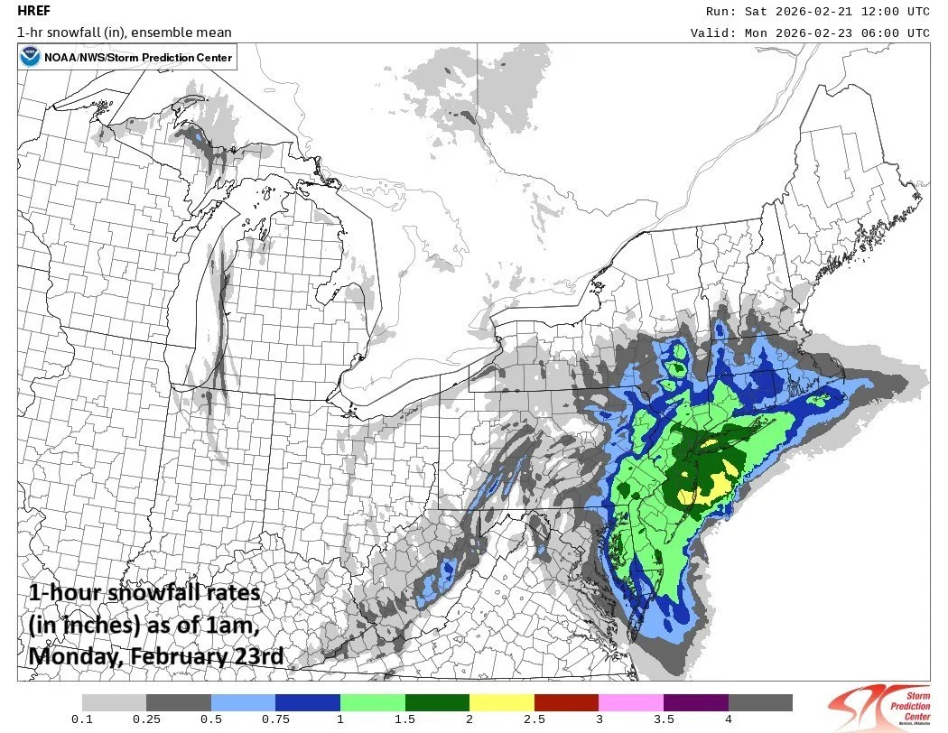
This map shows the mean snowfall amounts from an “ensemble” run of a high-resolution forecast model with high levels of as much as 2 feet depicted across the eastern Mid-Atlantic region. Map courtesy NOAA
Following the storm, a much colder-than-normal air mass will flood the eastern states and temperatures will drop well below-normal all the way down to the state of Florida. In fact, the coldest core of this incoming air mass – relative to normal - will end up in the Tennessee Valley/Southeast US during the early part of next week.
Check back here at arcfieldweather.com for updates…as always, a fluid situation.
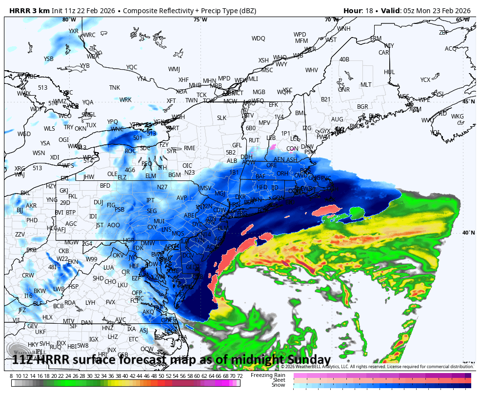
Surface forecast map for midnight Sunday by the 11Z HRRR with snow (blue) throughout the eastern Mid-Atlantic. Map courtesy NOAA, Weather Bell
Meteorologist Paul Dorian
Arcfield
arcfieldweather.com