**A significant and potentially record-breaking warmup this week with 90+ degrees on the table...some similarities to April 1976...MJO suggests we’re not done yet with the chilly air outbreaks**
Paul Dorian

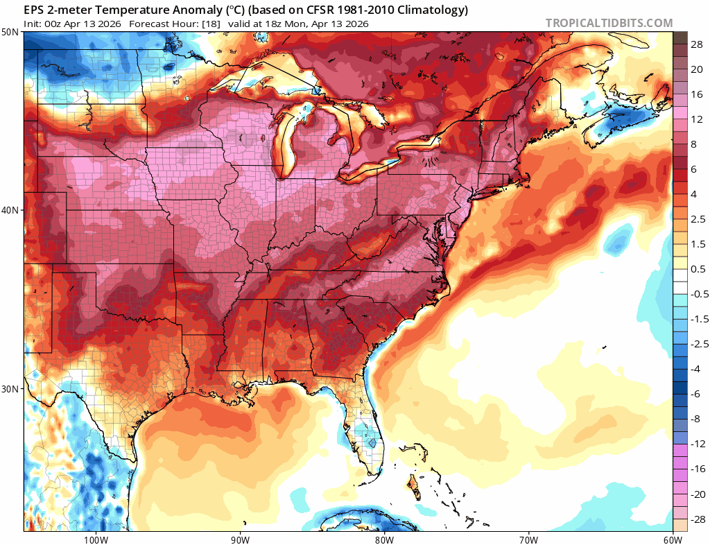
A significant and potentially record-breaking warmup is coming to the eastern states this week with daily high temperature records on the table in the Tuesday, Wednesday, Thursday time period. Maps courtesy ECMWF, tropicaltidbits.com
Overview
Most have been waiting for this kind of warmup in the eastern states following several false starts this season, but this may end up being a little too much on the extreme side. Not only are daily high temperature records in jeopardy this week in the Mid-Atlantic region with 90+ degrees on the table, but a few spots could experience their highest April temperatures ever recorded although it will be tough to beat the heat wave of April 1976. This warmup should last well into the upcoming weekend, but there are strong signs that another chilly air outbreak is destined to reach the northeastern part of the country by early next week. In fact, there are signs that additional colder-than-normal air masses will impact the central and eastern states during the last week of April at the same time a teleconnection index known as the Madden-Julian Oscillation or MJO shifts into a colder-than-normal phase for this time of year.
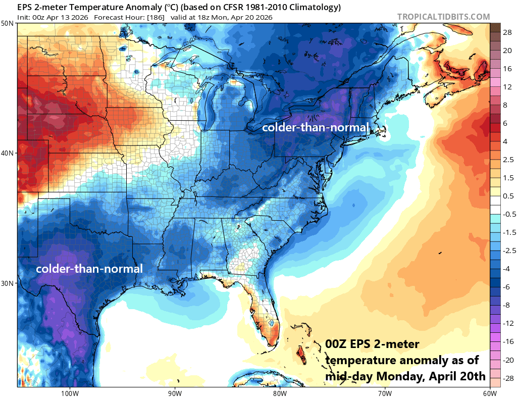
This coming warmup will likely last into the upcoming weekend, but a colder-than-normal air mass is destined to reach the northeastern states by the early part of next week. Map courtesy ECMWF, tropicaltidbits.com
Details
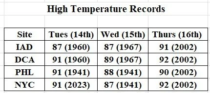
Air conditioners will get their first test of the year so far this week with a significant warmup coming to the Mid-Atlantic that will bring summer-like temperatures to the region. The peak of the warmup may come during the next three days with daily high temperature records in jeopardy on Tuesday, Wednesday, and Thursday in the DC-to-Philly-to-NYC corridor as the mercury can soar into the low-to-mid 90’s in some spots. In addition, it is not out of the question that some spots in the Mid-Atlantic region threaten to reach all-time high temperatures for the month of April; however, the heat wave of April 1976 (Bicentennial Year) will make that a hard threshold to top. (For example, New York City reached 96 degrees during the April 1976 heat wave; Baltimore, MD and Allentown, PA reached 93 degrees).
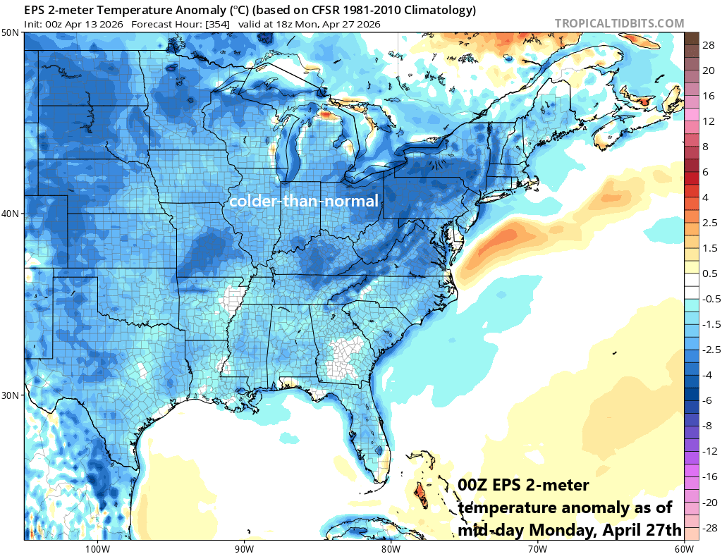
There are signs that the pattern flips to colder-than-normal for the central and eastern states by the last week of April. A teleconnection index known as the Madden Julian Oscillation or MJO will push into what is normally a colder-than-normal phase this time of year in the eastern half of the nation. Map courtesy ECMWF, tropicaltidbits.com
This upcoming warmup will likely last into the upcoming weekend, but a strong cold front may push into the eastern states by Sunday or Sunday night, and a colder-than-normal air mass seems destined to reach the northeastern states by early next week. In fact, this may not be the end of the chilly air outbreaks for the central and eastern states.
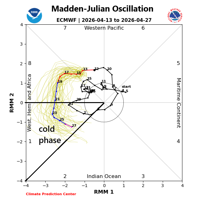
The MJO tracks a tropical disturbance around the globe and its location or “phase” is often well correlated with certain temperature patterns across the US depending on the time of year. In this case, the MJO is predicted to push into “phase 1” later this month which is normally a colder-than-normal location for the eastern half of the country. Map courtesy NOAA, ECMWF
A teleconnection index known as the Madden Julian Oscillation or MJO will be moving into what is normally a colder-than-normal phase by the last week of this month suggesting colder-than-normal air masses will continue to have an impact on the central and eastern states.
Meteorologist Paul Dorian
Arcfield
arcfieldweather.com
Follow us on Facebook, Twitter, YouTube
Video discussion: