*El Nino continues to unfold across the equatorial Pacific...signs point to a strong event with implications on the upcoming tropical season and potentially next winter as well*
Paul Dorian

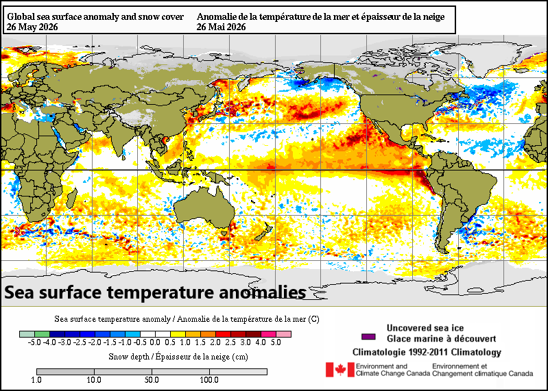
Sea surface temperatures continues to rise across the equatorial Pacific Ocean as an El Nino event gets underway. El Nino will have implications on the upcoming tropical season and it could potentially last long enough to have implications on the winter season of 2026-2027. Map courtesy Canadian Met Centre
Overview
El Nino is on the way, and it looks like it will be a strong event...
The equatorial Pacific Ocean is transitioning into El Nino conditions (i.e., warmer-than-normal sea surface temperatures) and signs point to a strong event by the summer and fall seasons with big implications on tropical activity in the Atlantic Basin. Looking ahead, it appears this El Nino event may even last into the upcoming winter season of 2026-2027 which no doubt would have some implications across the continental US.
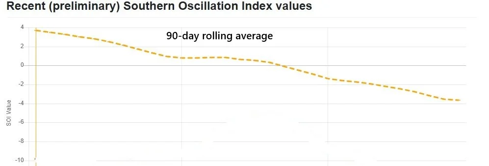
The trend is down for the Southern Oscillation teleconnection Index or SOI and sustained “negative” readings are usually well correlated with developing or intensifying El Nino conditions. Plot courtesy Australia web site known as “long paddock”
El Nino on the rise
Water temperatures continue to rise across the tropical Pacific Ocean as very warm water from underneath the surface “bubble” up to the top level. The recent temperature reading in all four El Nino regions (4, 3.4, 3, 1+2) feature above-normal conditions with the greatest difference from normal just off the west coast of South America (i.e., region 1+2). A teleconnection index known as the Southern Oscillation Index or SOI suggests this trend of warming will continue in upcoming days and numerous computer forecast models support this idea. The SOI is the longest lasting teleconnection index that provides us with information on the El Nino Southern Oscillation or ENSO. The SOI factors in the pressure difference between two areas of the Southern Hemisphere – Darwin Australia and Tahiti – and sustained “negative” readings usually is well correlated with the development of intensification of El Nino conditions in the tropical Pacific and recent values suggest water temperatures will continue to rise in coming days.
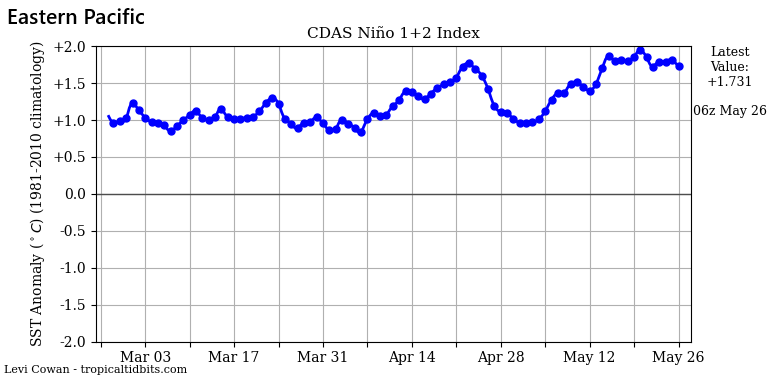
Water temperatures are already above-normal in the eastern Pacific Ocean (region 1+2) as El Nino continues to intensify. Plot courtesy NOAA< tropicaltidbits.com
Impact on the upcoming tropical season in the Atlantic Basin
The rise of El Nino in the tropical Pacific will certainly have some implications on the upcoming tropical season in the Atlantic Basin which officially beings on June 1st. El Nino will likely be a big inhibiting factor to the Atlantic Basin tropical season due to increased subsidence and wind shear (hostile conditions for tropical systems). In addition, sea surface temperatures are actually markedly below-normal in much of the Atlantic Basin from coastal waters of Africa to the Caribbean Sea – also an inhibiting factor to the formation or intensification of tropical activity.
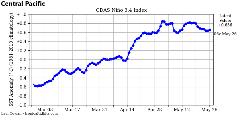
Water temperatures are already above-normal in the central Pacific Ocean (region 3.4) as El Nino continues to intensify. Plot courtesy NOAA< tropicaltidbits.com
Potential impact on the 2026-2027 winter season
Signs point to the continuation of El Nino conditions as we head into the early part of 2027 which means there can be a big impact next winter across the continental US. However, it is a little too early to have a handle on its magnitude this far ahead and another metric that will need to be determined in coming months is where the most warming will take place relative-to-normal.
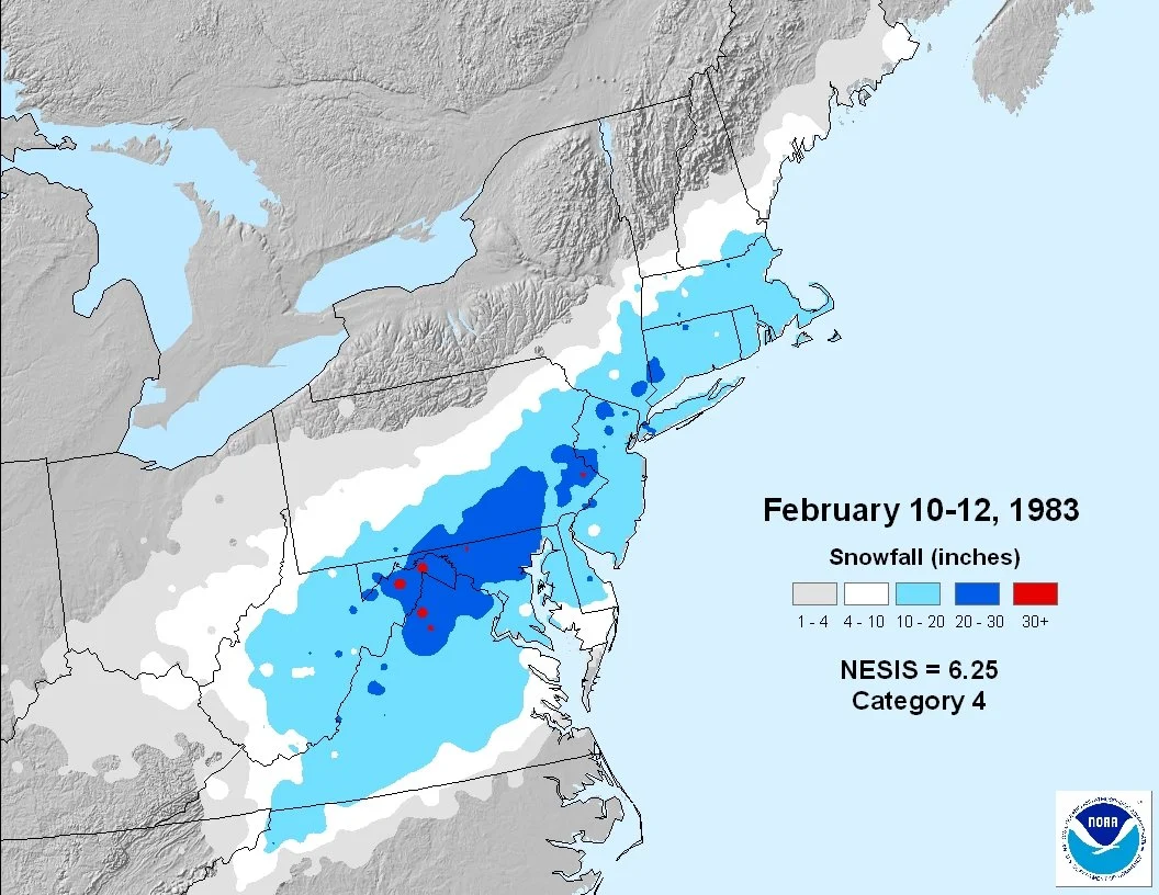
A warmer-than-normal El Nino winter can still bring about a major snowstorm to the Mid-Atlantic region and Northeast US. In fact, the strong El Nino event of 1982-1983 produced one of the greatest nor’easters to the I-95 corridor in February during an overall warmer-than-normal winter season. Map courtesy Dr. Louis Uccellini/Paul Kocin; NOAA
An “east-based” El Nino with the warmest water relative-to-normal sitting just off the west coast of South America (as is currently the case) could overwhelm the US with mild Pacific air for next winter. However, a “central-based” event would open the door for some troughiness in the eastern US (and potentially some colder air compared to the “east-based” scenario)...just too early to say. An interesting note, the average of those three strong El Nino events in recent history (i.e., 1982-1983, 1997-1998, 2015-2016) produced much warmer-than-normal conditions in much of the country with the exception being the southwest US. However, a warmer than normal winter does not preclude the chance for big-time snowstorms as was the case in February 1983 during what was an overall warmer winter when a nor’easter pounded the I-95 corridor.
Meteorologist Paul Dorian
Arcfield
arcfieldweather.com
Follow us on Facebook, Twitter, YouTube
Video discussion: