***Another severe weather and heavy rainfall risk for the Mid-Atlantic...refreshing air mass to follow..."Bertha" on the way***
Paul Dorian
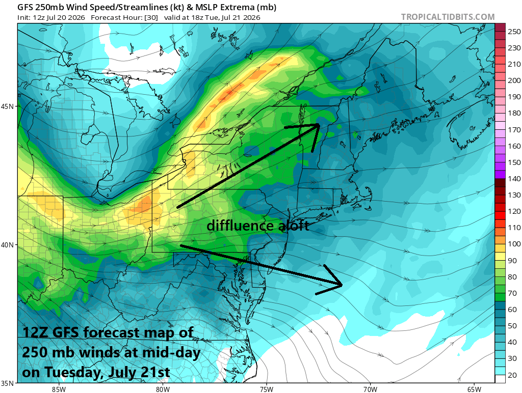
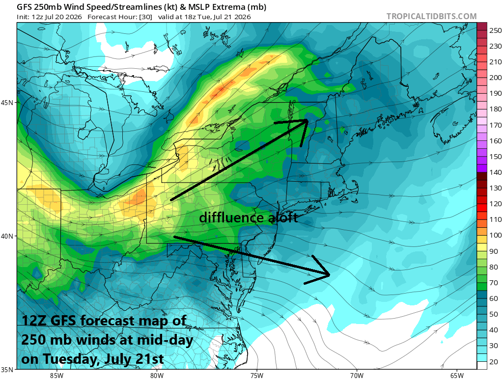
Many ingredients will come together on Tuesday to increase the chance of severe weather in the Mid-Atlantic region including enhanced upward motion connected with an impressive jet streak aloft. Map courtesy NOAA (GFS), tropicaltidbits.com
Overview
Severe weather affected the Mid-Atlantic region on Saturday, and another threat is on the way for later tomorrow. Not everyone will get hit by the strong storms, but ingredients are coming together for what looks like multiple rounds of showers and thunderstorms...some of the storms can be severe and some of the rain can be heavy. Showers and thunderstorms can linger into mid-week; especially across the southern part of the Mid-Atlantic and then a refreshing air mass will arrive on Wednesday night and Thursday. Meanwhile, there is an intensifying tropical system over the northern Gulf, and it is likely to reach named tropical storm status (would be Bertha) in the near term.
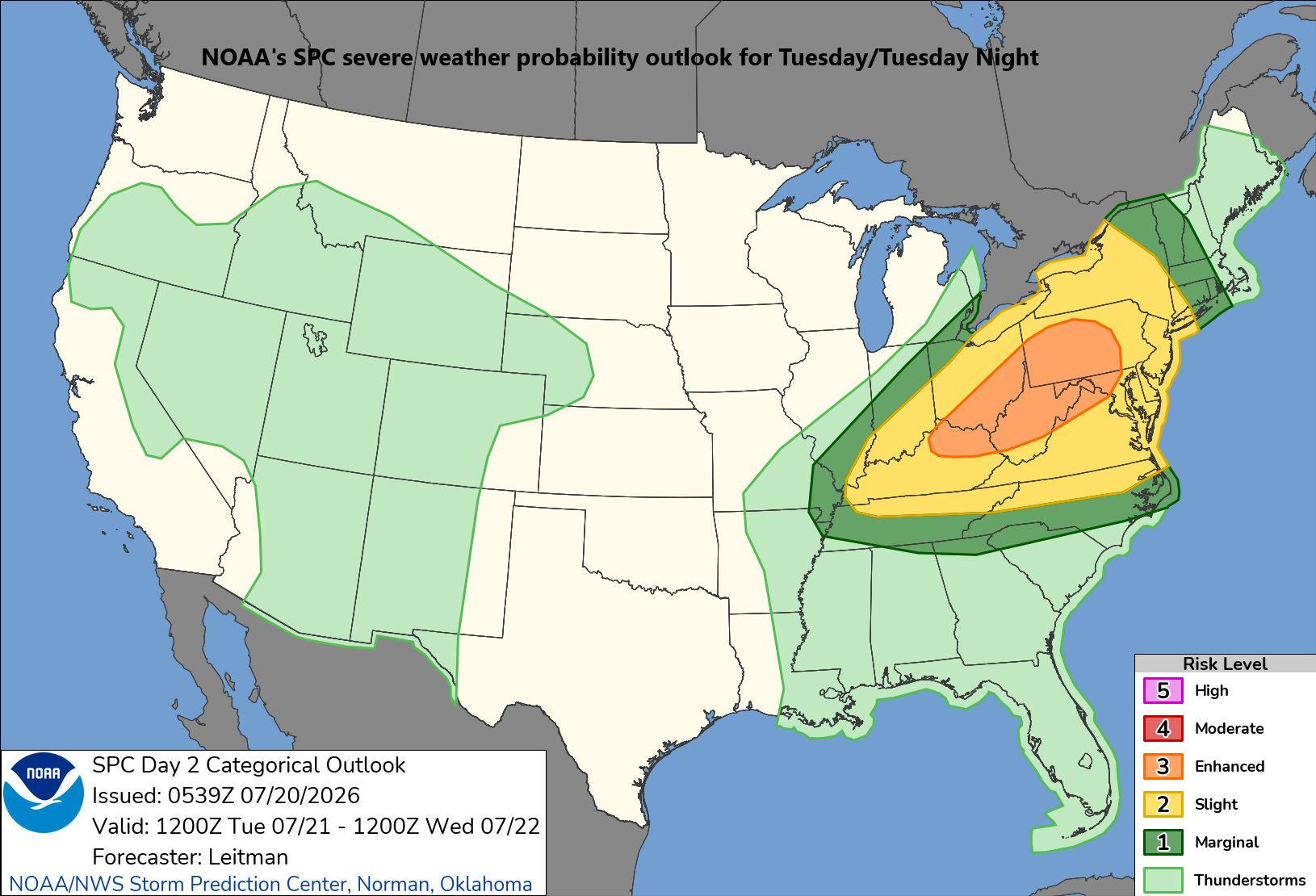
The Mid-Atlantic region, Ohio Valley and parts of the NE US is in the severe threat zone for Tuesday and Tuesday night according to NOAA’s Storm Prediction Center.
Severe weather threat Tuesday/Tuesday Night
Unsettled weather returns to the Mid-Atlantic region later tonight and it will continue into the day on Wednesday, and this can include severe thunderstorm activity focused on the PM hours on Tuesday. Much like this past weekend, several ingredients will be coming together to increase the chance of severe weather from later tomorrow into tomorrow night including an impressive upper-level jet streak that is pushing across the northern states. This jet stream will result in a diffluent flow over the Mid-Atlantic region which will be balanced by confluence at the surface...all of which will enhance upward motion helping to destabilize the atmosphere.
In addition to the jet streak, an upper-level trough of low pressure will slide into the northeastern US, and a surface cold front will head towards the region with low-level moisture amounts rising noticeably on its front side. Dew point temperatures – a true measure of overall atmospheric moisture – are generally in the comfortable 50’s on Monday, but should rise noticeably on Tuesday ahead of the incoming cold front likely reaching the upper 60’s and lower 70’s.
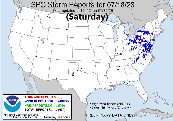
The severe weather event on Saturday, July 18th brought hundreds of damaging wind reports (blue markers) to the Mid-Atlantic region and damaging wind gusts is a concern for Tuesday/Tuesday night. Map courtesy NOAA/SPC
As with the weekend severe weather event, there are likely to be multiple rounds of showers and thunderstorms on Tuesday including one that can affect parts of the area from the wee hours early tomorrow to the mid-morning. Activity in the afternoon and evening will likely be more widespread and looks to pose the greatest risk of severe weather with the primary hazard being damaging wind gusts. There were hundreds of damaging wind gusts on Saturday in the Mid-Atlantic; hopefully, we won’t have a repeat performance, but that risk is on the table. As far as heavy rainfall is concerned, given the expected rapid rise in low-level moisture (as indicated by dew point increase), the threat of downpours will be there and localized flash flooding cannot be ruled out.
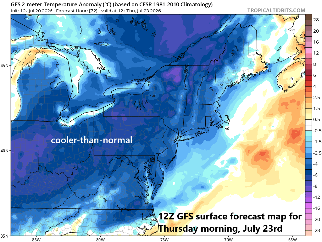
A refreshing air mass will push into the Mid-Atlantic region on Wednesday night and the latter part of the week looks to be quite comfortable. Map courtesy NOAA, tropicaltidbits.com
Refreshing air mass to follow
Showers and thunderstorms could linger into the day on Wednesday in parts of the Mid-Atlantic, and the zone of severe weather is likely to shift southeast a bit to places like the Delmarva Peninsula, eastern VA and northeastern NC. By Wednesday night, the cold front should push off the eastern seaboard, and a refreshing air mass will arrive in the Mid-Atlantic region and last into the upcoming weekend. Temperatures should be in the comfortable range on Thursday and Friday, dew points as well, and overnight lows can bottom out in the 50’s in many spots later in the week...something to look forward to, but there may be a price to pay before we get there.

There now appears to be some “rotation” surrounding the low-level center over the northeastern Gulf…a sure sign of intensification. This system should become the second named tropical storm of the young season (Bertha) and could cross southern Louisiana at mid-week. Images courtesy NOAA, college of DuPage
Tropical activity in the Gulf
In terms of tropical activity in this young season, a wave is beginning to intensify over the northern Gulf and it likely will become the second named system of the season (Bertha). Latest imagery shows a bit of a rotation around a low-level center over the northeastern Gulf - a sure sign of intensification - and favorable environmental conditions in the near-term should result in “Bertha” to be formed. This system is likely to then meander in a general westward direction in coming days and could cross the southern part of Louisiana during mid-week potentially bringing some decent rainfall from Florida’s Panhandle to northeastern Texas.
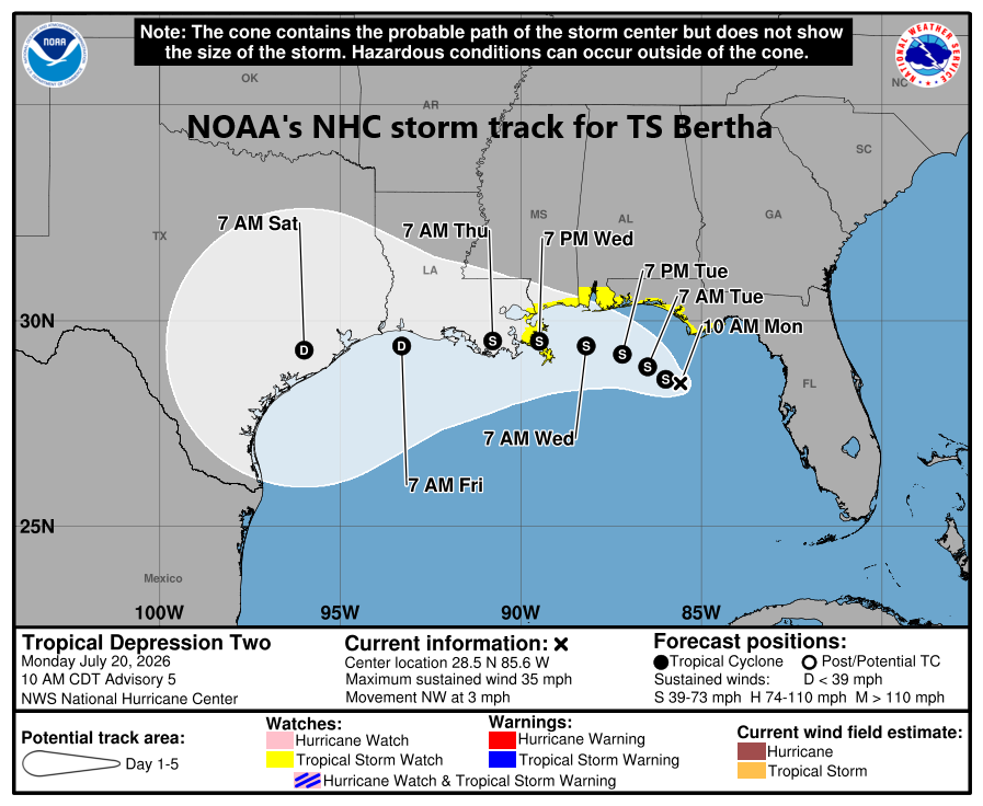
Tropical Storm Bertha is likely to form in the near-term and it should meander in a general westward direction and could cross southern Louisiana at mid-week. Map courtesy NOAA/NHC
Meteorologist Paul Dorian
Arcfield
arcfieldweather.com
Follow us on Facebook, Twitter, YouTube
Video discussion: