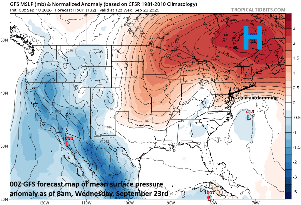
***Unusually strong “cold air damming” setup to result in big-time cool down next week for DC, Philly, NYC…unsettled pattern as well with occasional rain that can be heavy at times...nor'easter?***
Paul Dorian
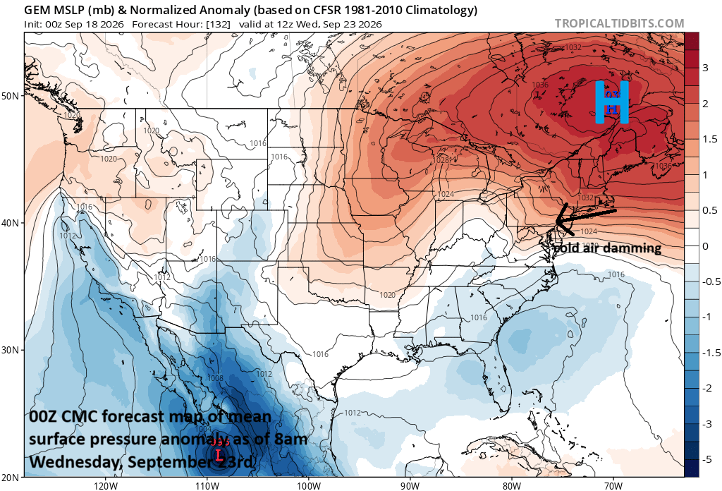
An unusually strong “cold air damming” scenario is likely to develop by the middle of next week with powerful high pressure centered over southeastern Canada. The clockwise flow of air around high pressure systems should result in an extended period of east-to-northeast flow next week for the DC-to-Philly-to-NYC corridor. Map courtesy Canadian Met Centre, tropicaltidbits.com
Overview
Temperatures have been consistently peaking well up in the 80’s in recent days along the DC-to-Philly-to-NYC corridor, but there can be quite a change by the middle of next week. An unusually strong “cold air damming” setup is looking likely with deep high pressure centered over southeastern Canada and this could limit temperatures to the 60’s along the I-95 corridor. In addition to the high-pressure system to the north, this scenario will feature a slow-moving frontal boundary zone that will allow multiple low pressure systems to ride along bringing plenty of moisture into the Mid-Atlantic region. And there is the chance that one of these low pressure systems intensifies just off the Mid-Atlantic coastline in “nor’easter” fashion. The bottom line…occasional rain is likely from Sunday into the middle of next week and some of the rain can be heavy at times to go along with much cooler-than-normal temperatures.
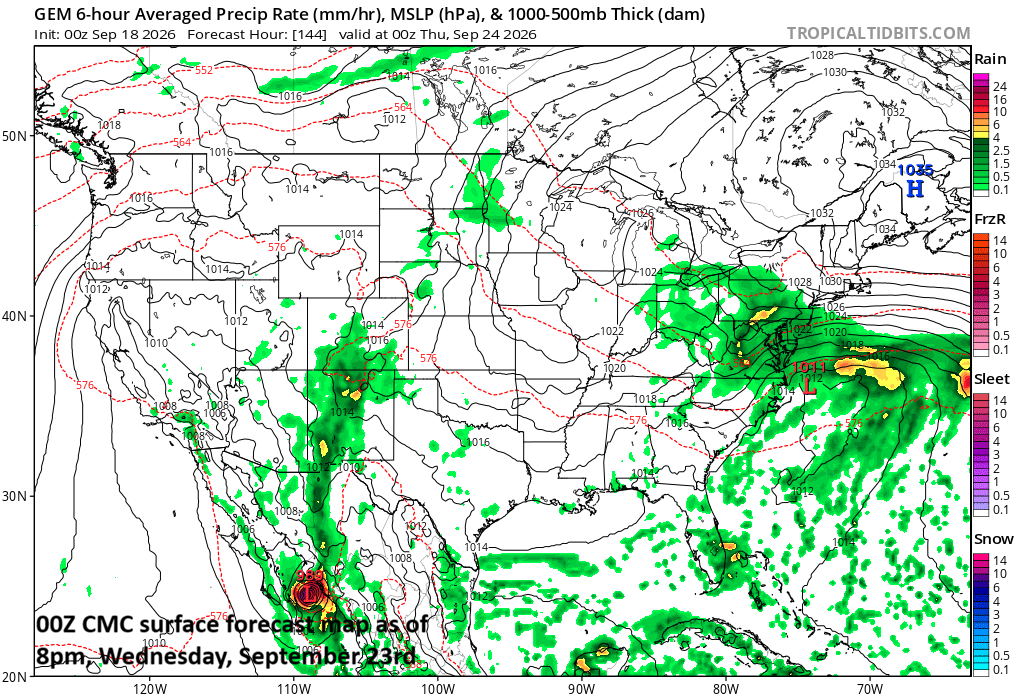
One key player to the coming big-time cool down will be strong high pressure centered over southeastern Canada during the early part of next week. A second important player could be a low pressure system that may consolidate just off the Mid-Atlantic coastline (in “nor’easter” fashion) by the middle of next week. Map courtesy Canadian Met Centre, tropicaltidbits.com
Details
Average high temperatures this time of year in the DC metro region are around 80 degrees, but we could be looking at the low-to-mid 60’s by the middle of next week. An unusually strong “cold air damming” scenario is looking likely anchored by a powerful high-pressure system centered over southeastern Canada. As a result, a stiff flow of air from the east-to-northeast is likely to form producing far below normal temperatures to the DC-to-Philly-to-NYC corridor by Tuesday and Wednesday of next week.
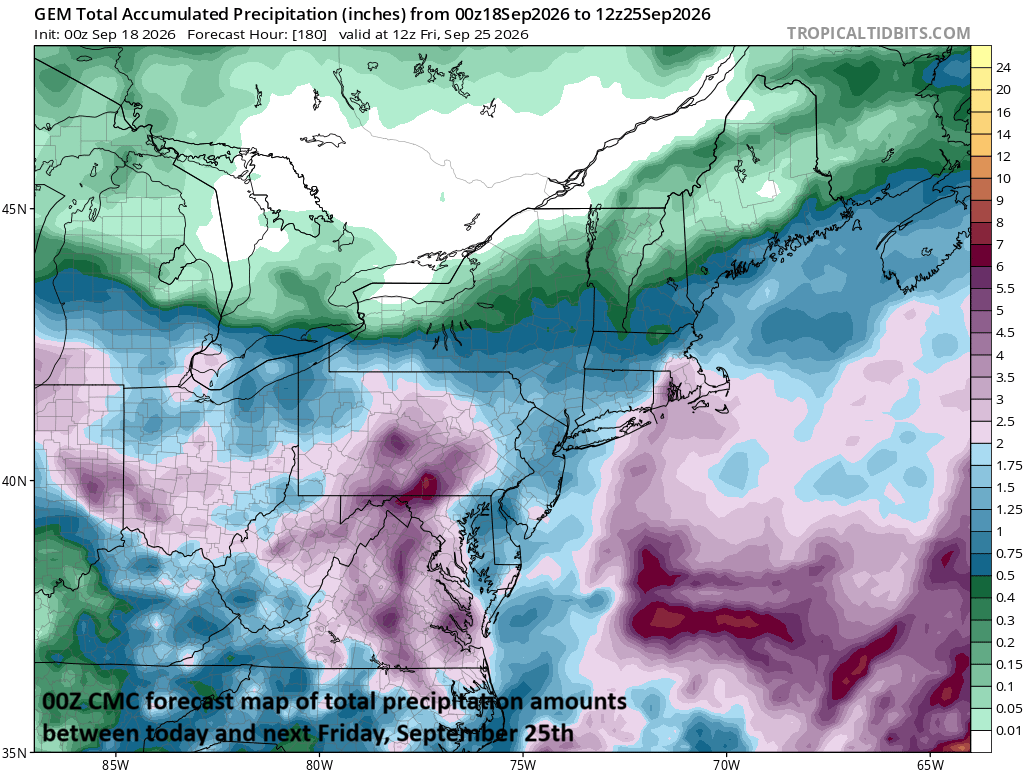
Occasional rain is likely in the Mid-Atlantic region from Sunday into the middle of next week and some of the rain can be heavy at times. Map courtesy Canadian Met Centre, tropicaltidbits.com
In addition to the coming chill down, the weather will become quite unsettled in the Mid-Atlantic region with the chance of occasional rain from Sunday into the middle of next week. High pressure moves out to sea on Saturday night, and then low pressure organizes over the Midwest. That low pressure system will lift a warm front through the area early Sunday paving the way for more moisture to push in from the south and rain can break out in the afternoon and evening…possibly heavy at times. A cold front then follows on Sunday night and pushes slowly to the south on Monday morning before stalling out over the Delmarva.
This frontal boundary zone will act as a conduit for multiple low pressure systems to ride along, bringing lots of moisture into the Mid-Atlantic region during the first half of next week and occasional rain. There may even be a significant intensification of low-pressure just off the Mid-Atlantic coastline by the middle of next week with a similar look to it as a winter-time “nor’easter”. If this would occur, the cool, wet stretch of weather in the Mid-Atlantic region could extend all the way into the latter part of next week.
Meteorologist Paul Dorian
Arcfield
arcfieldweather.com