You can edit the text in this area, and change where the contact form on the right submits to, by entering edit mode using the modes on the bottom right.
123 Street Avenue, City Town, 99999
(123) 555-6789
email@address.com
You can set your address, phone number, email and site description in the settings tab. Link to read me page with more information.
In a dramatic rain-filled game on Sunday in Philadelphia, the Phillies clinched the National League championship and will play the Houston Astros in the World Series beginning this Friday night, October 28th. The weather in Philly on Sunday appeared to have an impact on the game with, for example, numerous wild pitches during a crucial part of the game while the rain was falling quite hard. The first two games of the World Series are set for Houston’s Minute maid Park and the weather is very likely to not have any impact since the stadium has a retractable roof which presumably would be closed if inclement conditions developed. In recent history, the weather has indeed had a big impact on at least a handful of World Series games with conditions ranging from biting cold-to-extreme heat and from rain-to-snow as well.
On September 21, 1938, one of the most destructive and powerful hurricanes in recorded history struck Long Island and Southern New England. It was the first major hurricane to strike New England since the year 1869. The storm developed near the Cape Verde Islands on September 9, tracking across the Atlantic and up the Eastern Seaboard. The storm hit Long Island and Southern Connecticut on September 21, moving at a forward speed of 47 mph! Today marks the 84th anniversary of storm known as "The Great New England Hurricane of 1938" as well as "The Long Island Express" and the "Yankee Clipper". With no warning, the powerful category 3 hurricane (previously a category 5) slammed into Long Island and southern New England causing approximately 682 deaths and massive devastation to coastal cities and became the most destructive storm to strike the region in the 20th century. Little media attention was given to the powerful hurricane while it was out at sea as Europe was on the brink of war and the overriding story of the time. There was no advanced meteorological technology such as radar or satellite imagery to warn of the storm’s approach.
At the end of the 19th century, America was beaming with confidence and feeling bigger and stronger than ever before. The city of Galveston, Texas was booming with a population of 37,000 residents on the east end of Galveston Island which runs about thirty miles in length and anywhere from one and a half to three miles in width. Its position on the harbor of Galveston Bay along the Gulf of Mexico made it the center of trade and the biggest city in Texas in the year 1900. A quarter of a century earlier, a nearby town was destroyed by a powerful hurricane and this object lesson was heeded by many Galveston residents and talks of a seawall to protect the city were quite prevalent. However, no seawall was built and sand dunes along the shore were actually cut down to fill low areas in the city, removing what little barrier there was to the Gulf of Mexico. This proved to be a fatal mistake for the city of Galveston in what nobody could foresee happening to this magical place that seemed destined to become the New York of the Gulf of Mexico.
The sun continues to be peppered with sunspots in recent days as solar cycle 25 progresses towards the next solar maximum and there can be a couple of minor-to-moderate geomagnetic storms during the next few days. There has been only one day this year with no visible sunspots continuing a downward trend that began during the height of the last solar minimum in 2019. It remains to be seen just how strong solar cycle 25 becomes over the coming months, but even weak solar cycles can produce significant solar storms. In fact, it was this same time of year back in 1859 when a super solar storm - now known as the “Carrington Event” - took place during another weak solar cycle (#10). The event has been named for the British astronomer, Richard Carrington, as he observed from his own private observatory the largest solar flare which caused a major coronal mass ejection (CME) to travel directly toward Earth.
Recent studies have warned that these type of super solar storms may not be quite as rare as once thought (e.g., Hayakawa et al). Many previous studies of solar superstorms leaned heavily on Western Hemisphere accounts according to spaceweather.com, omitting data from the Eastern Hemisphere. This skewed perceptions of the “Carrington Event” of 1859, highlighting its importance while causing other superstorms to be overlooked. A super storm of the same magnitude as the “Carrington Event” in today’s world would very likely have a much more damaging impact than it did in the 19th century potentially causing widespread power outages along with disruptions to navigation, air travel, banking, and all forms of digital communication.
It was shortly after noon on August 24th in the year 79 A.D. and Mount Vesuvius sent a tall cloud of steam and ash high up into the atmosphere. The ancient Roman town of Pompeii near modern day Naples was soon covered in complete darkness and the thickness of the falling debris increased by about 6 to 8 inches per hour. The rocks which comprised the debris were up to 3 inches in diameter and fell with a speed of up to 100 miles/hour. This first phase of the eruption led to casualties primarily caused by roof collapses. After 12 hours of continuous explosive activity, the second phase of the eruption began and it was characterized by substantial flow of lava down the sloping Mount Vesuvius and this caused additional deaths and destruction. In fact, the eruption of Mount Vesuvius spewed 1.5 million tons of lava per second into Pompeii and surrounding towns. In a short period of time, two thousand people were killed, the small towns of Herculaneum, Oplonti and Stabiae were destroyed, and Pompeii was changed forever.
In a movie filled with memorable quotes, one of the shortest and simplest might have been “It’s a Twister!”, but it was part of a tornado scene that is still considered to be a classic more than eight decades later. August 25, 1939 was the official release date of the “Wizard of Oz" which was the first movie to depict an authentic looking tornado using improbable “1930’s style” special effects. Through the decades, this all-time classic has inspired movie-goers and “weather weenies” alike with the scene of a twister lifting Dorothy’s home into the sky over rural Kansas farm land.
1969 was a remarkable year and will be long remembered as the year when man first walked on the moon, the Miracle Mets shocked the sports world, and the Woodstock Festival took place in upstate New York. It will also be remembered as the year when a major hurricane –Hurricane Camille – struck the United States as a category 5 storm and the second most intense tropical cyclone on record (only the 1935 Labor Day hurricane had a lower central pressure at landfall). Hurricane Camille made landfall in Mississippi and wreaked havoc from the Gulf States to as far inland as the Mid-Atlantic with widespread flooding, record rainfall, and it cost the lives of several hundreds of people along its path of destruction.
July gets underway on Friday and no doubt there will be plenty of hot spells during the month across the nation. Indeed, July looks like it will begin with some very hot weather across the nation’s mid-section as temperatures are expected to be well above-normal for the first ten days or so. Despite the expected hot start in the much of the nation, July 2022 will certainly have a difficult time matching the extreme and sustained heat of July 1936. In fact, one of the most widespread and destructive heat waves ever recorded in the US took place in the summer of 1936 which fell right in the middle of arguably the hottest and driest decade ever for the nation.
The decade of the 1930’s is renowned for the “Great Depression” and the “Dust Bowl”, both of which caused calamitous human suffering in this country. Not only were huge numbers of crops destroyed by the heat and lack of moisture in the “Dust Bowl” era, but thousands of lives were lost as a result of the heat, drought and economic hardship. This extreme heat wave was particularly deadly in high population areas where air conditioning was still in the early stages of development. The heat wave experienced in 1936 began in late June, reached a peak in July, and didn’t really come to an end until September. Many of the all-time high temperature records that were set in the 1930’s in numerous cities and states still stand today. Perhaps the hottest day ever recorded in the US took place on July 14th in 1936 when the average maximum temperature was 96°F and 70% of the US was over 90 degrees.
Nowadays, when the people of New Orleans think of devastating hurricanes they think of Katrina, but before 2005, the most notorious storm name in Louisiana was Audrey. Sixty-five years ago today, Hurricane Audrey slammed into the southwest coast of Louisiana and became the earliest major hurricane (category 3) to make landfall in the US. Hurricane Audrey killed hundreds of people – estimated to be somewhere between 400 and 500 - including many of whom to this day remain unidentified and tragically, about one-third of those were children. The high number of deaths - in an era without satellite imagery - were attributed to the storm moving ashore earlier and stronger than predicted while most people were sleeping.
Track of Agnes from June 14th – June 23rd, 1972 (white circles indicate category 1 hurricane status); courtesy Wikipedia
Overview
The official Atlantic Basin tropical season was barely underway in June of 1972 when a polar front interacted with an upper-level trough of low pressure over the Yucatan Peninsula. Within a few days, a tropical depression formed and the system moved slowly eastward and emerged in the western Caribbean Sea by the middle of the month. The depression began to intensify over the warm waters of the Caribbean Sea and soon became Tropical Storm Agnes – the first named storm of the 1972 tropical season. Ultimately, Agnes would reach hurricane status, grow to a diameter of about 1000 miles, and become the costliest hurricane at the time to hit the US and the Commonwealth of Pennsylvania was the prime focus of its wrath.
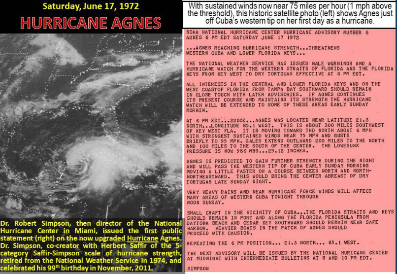
Satellite image of Agnes on the first day it reached hurricane status just off the western tip of Cuba. Courtesy NOAA
General Discussion
Tropical Storm Agnes intensified over the Caribbean Sea in the middle of June 1972 and began curving northward passing just to the west of Cuba on June 17th. By the next day, Agnes reached hurricane status and then made landfall near Panama City, Florida on June 19th as a category 1 (weak) hurricane. In typical fashion, the tropical system weakened once it moved over land and dropped back to “depression” status as it pushed northeastward into Georgia.
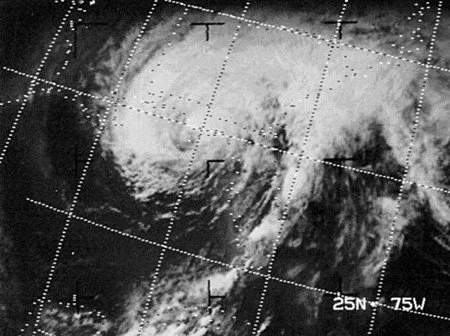
Close-up of Agnes approaching Florida as a category 1 hurricane in June 1972; courtesy NOAA
However, in this particular case, the tropical system then began to regain strength as it pushed through South Carolina and into eastern North Carolina. In fact, while over eastern North Carolina, Agnes regained tropical storm status as it was about to head out over the waters of the western Atlantic Ocean before re-curving northwestward and making landfall near New York City as a strong tropical storm. After this, Agnes ran into an atmospheric road block (i.e., upper-level blocking pattern) and this forced it to slow down and loop around into northern Pennsylvania where it eventually gradually dissipated. The slow movement of Agnes allowed for some incredible rainfall amounts to pile up in the Mid-Atlantic region; especially, in the Commonwealth of Pennsylvania.
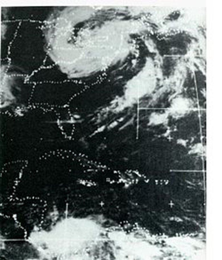
Satellite image of the remnants of Agnes once over the Northeast US; courtesy NOAA
Pennsylvania’s worst nightmare
The weeks before Agnes approached Pennsylvania in June 1972 were quite wet with numerous heavy rain events. As a result, a disaster was almost unavoidable with the onset of slow-moving Agnes as grounds were already saturated throughout much of the state. As Agnes slowed down to a grinding halt right over northern Pennsylvania, the rainfall amounts piled up across the state and there was intense flooding – more so than in any other state. In many cases, the rivers rose to levels not ever seen before. The highest rainfall amount of 19 inches was measured over western Schuylkill County and much of the state ended up with at least 7 inches of rain making Agnes the wettest tropical cyclone ever for the state of Pennsylvania (the city of Philadelphia got off easy with only a few inches).
On June 22, the murky waters of the Susquehanna River reached eight feet above normal. Fourteen hundred National Guardsmen were ordered to the area where they worked to secure low-lying areas by erecting walls of shale, sandbags, and rock. By Friday, June 23, the river swelled to 38.5 feet; the dike had long since buckled and left surrounding towns truly vulnerable. On June 23, 1972, Harrisburg’s Patriot-News was canceled for the first time since it began in 1852. By Saturday evening on June 24th, the water levels had reached their peak and Agnes pummeled Wilkes-Barre and the Wyoming Valley with 14 trillion gallons of water; submerging homes and destroying communities.
Floodwaters from Agnes surround the Governor’s mansion in Harrisburg, PA
Elsewhere, the Brandywine Creek crested at 16.5 feet in Chadds Ford (Delaware County) sending flooding waters into that city. In Reading, the Schuylkill River reached a record flood level of 31.5 feet and hundreds of people were evacuated. In the end, more than 100,000 people were forced to leave their homes across the state due to flooding including many in the capital city of Harrisburg where some buildings were under 13 feet of water. Gov. Milton Shapp and first lady Muriel Shapp were rescued by boat from the flooded governor's mansion. By the time the storm finally ended, there were 128 deaths directly attributed to Agnes and 50 of those occurred in Pennsylvania – more than twice that of any other state – and there were $2.3 billion in losses across the Keystone State.
Rainfall amounts from Agnes reached a peak in Pennsylvania with 19 inches recorded in western Schuylkill County
Impact on the DC metro region
Rainfall amounts were staggering across Pennsylvania and also in much of the DC metro region. Chantilly, Virginia, for example, recorded 16 inches from Agnes and 13.65" officially fell at Dulles Airport. Wind gusts peaked at around 50 mph at Dulles and National Airports (8.16” inches of rainfall recorded at DCA). The most tragic aspect of this event in the Washington D.C. area was the loss of sixteen people who were swept to their deaths in the swirling floodwaters. Most of these drownings involved motorists that were trapped in automobiles (credit Washington Post's Capital Weather Gang).
Final thoughts
Hurricane Agnes finally exited Pennsylvania on June 25, 1972 with its sights set on western New York. By most accounts, the scope of the devastation puts Hurricane Agnes at the top of Pennsylvania’s worst natural disasters, even though it did not cause the most deaths. The two deadliest, both of which occurred on May 31, were the Johnstown Flood of 1889 (2200+ fatalities) and the Great Pennsylvania Tornado of 1985 (65 fatalities) [credit Washington Post/Capital Weather Gang].
Agnes left quite a legacy among those who suffered her wrath; consequently, the name was retired by NOAA and barred from future use. In fact, Hurricane Agnes was the first category 1 hurricane in the Atlantic Basin to have its name retired and is today one of only five such storms with that distinction.