10:30 AM | **The quiet before the storm…major storm to bring heavy rain, powerful winds, possible drenching thunderstorms, and a feeling of spring to much of the eastern third of the nation**
Paul Dorian

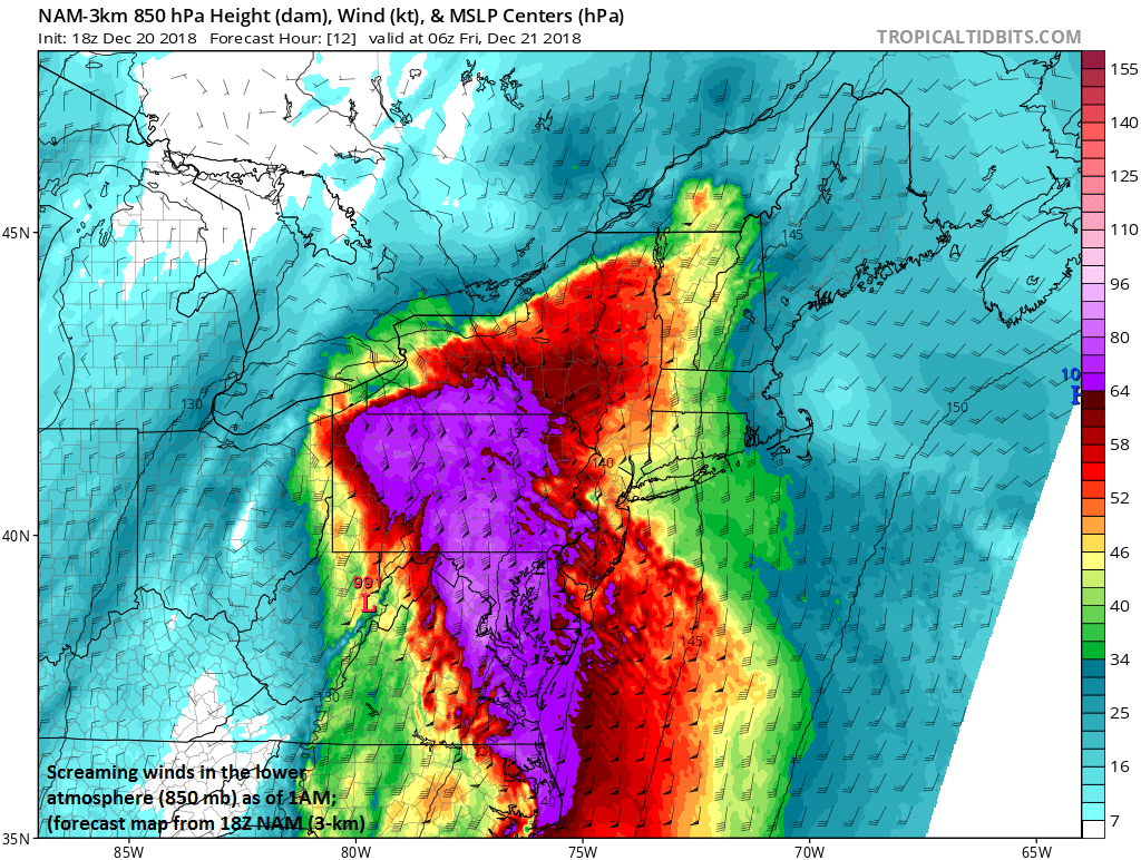
Powerful low-level jet to bring some very strong wind gusts to the Mid-Atlantic region in the overnight hours; courtesy NOAA/EMC, tropicaltidbits.com
Overview
Another significant rain event will get underway later today as a powerful storm begins to lift northeast from the northern Gulf of Mexico coastal region. This storm will not only bring us soaking rainfall – perhaps 2-3 inches with locally higher amounts – but also very strong wind gusts potentially past 50 mph. In addition, as the storm moves northward on Friday to the west of the I-95 corridor, warmer air will surge up the Atlantic seaboard and it’ll feel spring-like with temperatures climbing to 60+ degrees in the DC-to-Philly-to-NYC corridor. Given the already well-saturated grounds, localized flooding is likely to become a real concern over the next 24-48 hours.

Strong upper-level (500 mb) low in the northern Gulf region contributing to severe weather today across the Deep South and supporting the formation of a powerful surface-level low pressure system; courtesy NOAA/tropicaltidbits.com
Today/tonight
Conditions will deteriorate over the next few hours in the Mid-Atlantic region as intensifying surface low pressure begins to pull out of the northern Gulf coastal region and move northeastward towards the southern Appalachians. This surface system is supported by a potent wave of energy in the upper part of the atmosphere that is now digging (southward) on the west side of a large-scale trough. In addition, copious amounts of moisture is pouring northward from the Gulf of Mexico at this hour and Atlantic Ocean moisture will soon get involved with this storm system as well. Rain should break out later today in the Mid-Atlantic region - well ahead of the surface low - as a strong upper-level jet strengthens near the east coast.

A powerful storm continues to develop in the Deep South and there is plenty of moisture flowing northward towards the Atlantic seaboard; courtesy NOAA/GOES-16 (“natural” color imagery), College of DuPage
The rain will pick up in intensity after dark and heavy rain is very likely at times in the overnight hours and there can be a couple of drenching thunderstorms. Farther south and closer to the current positioning of the upper-level wave of energy, strong-to-severe thunderstorms have broken out and much of the state of Florida is under the gun for the potential of severe weather with numerous tornado watches in effect. After a cold start to the day around here, temperatures will struggle today to climb into the 40’s, but then they will actually rise through the 50’s in the overnight hours as strong southerly winds develop following the passage of a northward moving warm front. Don’t be surprised if some local thermometers show 60 degrees at daybreak on Friday and there will definitely be a feeling of spring as we close out the work week.

NOAA’s “weather warnings” map with tornado watches and warnings in Florida (yellow, red), winter weather advisories in northern New England (purple) for the (initial) threat of ice, and flash flood watches (green) extending from Florida to Maine; courtesy NOAA
Friday/Friday night/weekend
On Friday, the strong surface storm will slide northward along the spine of the Appalachians and to the west of the I-95 corridor producing strong southerly winds around here and temperatures will hold in the spring-like 60’s for much of the day. The steady rain of the overnight hours will evolve into a showery type of precipitation pattern on Friday, but there certainly can be more downpours and possibly some drenching thunderstorms to go along with the strong winds and unusual warmth. Showers will continue on Friday night, possibly heavy at times, as a cold front approaches on the back side of the storm and there can be more thunderstorms as the front pushes through the region from west-to-east. Colder and drier air will pour into the region late Friday night and early Saturday riding in on strong NW winds. While Saturday will be windy and cold, the overall weather conditions should be pretty decent for drying and some sunshine is possible. The weekend will close with dry, sunny and cold weather on Sunday and the winds will be much lower compared to Saturday.
In terms of total rainfall for this upcoming event, 2-3 inches are likely in the I-95 corridor between later today and late Friday night and there can even be some locally higher amounts. Needless to say, grounds are well saturated in the entire Mid-Atlantic region due to recent rainfall and the unusually high amounts from earlier this year. Rain totals for the year at Reagan National Airport (DCA) in Washington, D.C. and BWI (Marshall Airport) in Baltimore, Maryland have already broken records for the year with 64.22 and 68.82 inches respectively - more than 25 inches above normal at DCA and 28 inches above normal at BWI. Rain totals for the year at Philly Airport (PHL) are now over 55 inches which ranks second on the all-time list behind the record of 64.33" set in 2011.
Meteorologist Paul Dorian
Perspecta, Inc.
perspectaweather.com
Video discussion: