1:10 PM (Tuesday) | ***Significant snow from the Rockies to Upper Midwest...heavy rain, damaging winds and inland snows in CA/OR...ice/snow likely this weekend in Mid-Atlantic/NE US***
Paul Dorian

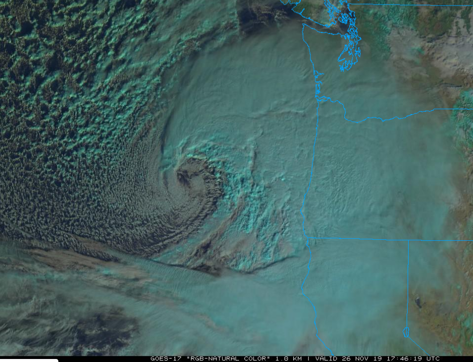
The latest satellite image of the powerful storm over the eastern Pacific which will have a major impact on Oregon and California over the next 24 hours or so. This same storm will then take a trek across the nation in coming days and potentially produce significant ice and snow this weekend in the Mid-Atlantic/NE US. Image courtesy College of DuPage, NOAA GOES-17
Overview
One major storm is bringing heavy snowfall to parts of the Rocky Mountains and central Plains and another is about to slam into the west coast of the US. Heavy snow from the first storm continues across the Rockies and has stretched into the central Plains and it’ll make a push into the Upper Midwest on Wednesday. This same system will then head eastward and drag a strong cold front across the Mid-Atlantic/NE US tomorrow evening and the winds will become quite strong with gusts past 40 mph. The second major storm will rapidly intensify before making landfall later tonight near the California/Oregon border and it will bring heavy rain and damaging winds to coastal sections and tremendous snows to inland higher elevation locations of the Sierra Nevada mountain range where the snow will be measured in feet over the next few days. This second storm will cross the nation and arrive in the Mid-Atlantic/NE US this weekend where there will be a lot of cold air and accumulating ice and snow could be the result in interior sections.

NOAA’s “weather warnings map” is full of colors - not a good sign - ranging from hurricane warnings off the west coast with storm #2 to blizzard warnings in Colorado from storm #1. Map courtesy NOAA
Initial storm
One of the biggest snowstorms ever recorded for November in parts of Colorado continues to pound away in the Rocky Mountains and into the central Plains. More than 20 inches has been reported in Boulder and this storm is likely to end up in the top 5 of all-time for such places in Colorado as Boulder, Fort Collins and Loveland where final accumulations of 1-2 feet are likely. The snow has pushed into the central Plains (e.g., Nebraska) and will move northeastward on Wednesday into the Upper Midwest where accumulations will also be significant. The upper-level low associated with this storm will then take a turn to the east and trek over the Great Lakes and into the NE US. A strong cold front will be dragged through the Mid-Atlantic/NE US on Wednesday evening as the surface low slides by to the north. Winds will pick up noticeably ahead of the front passage later tomorrow from a southwesterly direction and then are likely to gust past 40 mph from the northwest on Wednesday night and Thursday in the Mid-Atlantic/NE US. There will be a few showers associated with this frontal system later tomorrow, but the winds will be the bigger story.

A powerful storm will slam into Oregon/California later tonight and Wednesday resulting in heavy rain and damaging wind gusts for coastal sections and tremendous snowfall across the Sierra Nevada. Map courtesy NOAA, tropicaltidbits.com
Second storm
A major storm is now intensifying off the west coast of the US and it will become quite a powerhouse by the time it makes landfall later tonight near the Oregon/California. This ocean storm will produce significant rain and damaging winds for coastal sections of Oregon and California over the next 24 hours with hurricane-force gusts on the table. Heavy mountain snows are likely inland across the Sierra Nevada mountain range where snow will be measured by the foot over the next couple of days.

The upper-level low associated with the incoming Pacific Ocean storm will pull out of the western US and heads towards the Northern Plains. At this point, this feature will run into an “atmospheric roadblock” and be forced to slide southeast allowing for cold air to build-up in the Mid-Atlantic/NE US this weekend. Maps courtesy NOAA, tropicaltidbits.com
The deep upper-level low associated with this intensifying storm will take a trek from the western US to the Northern Plains over the next few days, but at that point, it’ll run into a “atmospheric roadblock” in the atmosphere as high pressure ridging builds across southern Canada and this will force a slide to the southeast. The blocking to the north and the change in path to the southeast will be critical as it will allow for cold air to extend southward into the Mid-Atlantic/NE US this weekend before the system arrives. This all could result in accumulating ice and/or snow for interior locations at the onset of the weekend storm in the late Saturday/early Sunday time frame before a possible changeover to plain rain on Sunday – at least in some sections. In addition, once this storm reaches the Mid-Atlantic coastline late in the weekend, it could pull in enough cold air from the northwest to allow for a changeover from rain back to snow in many spots.

Cold air will be in place this weekend across the Mid-Atlantic/NE US when precipitation arrives from the second major storm to impact the nation this week potentially leading to some significant ice and/or snow across interior sections. Maps courtesy NOAA, tropicaltidbits.com
Stay tuned…the last week of November will be very active for much of the nation and it looks like December will get off to quite an interesting start.
Meteorologist Paul Dorian
Perspecta, Inc.
perspectaweather.com
Video discussion: