11:35 AM | ***A more threatening situation for the Bahamas and perhaps Florida, but the rest of the Southeast US has to stay on guard as well..."major" hurricane on the table***
Paul Dorian

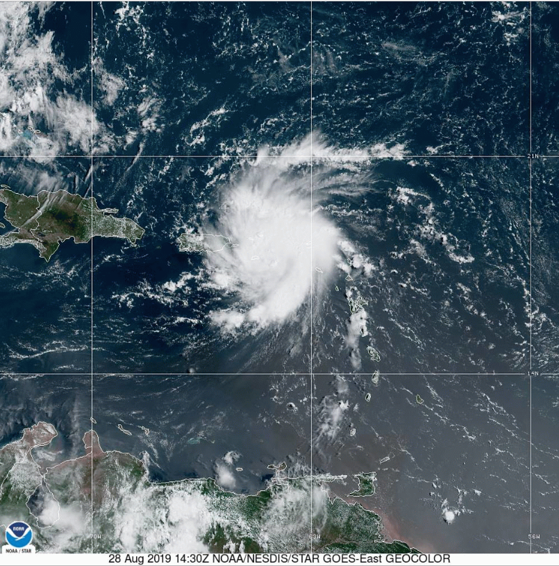
Tropical Storm Dorian is now impacting Puerto Rico and the Virgin Islands. At 11AM, it has max sustained winds at 70 mph - not far from hurricane status. Courtesy NOAA
Overview
All residents from North Carolina to Florida should closely monitor Tropical Storm Dorian over the next few days as it can have a major impact by later this weekend or early next week in any part of this region. Tropical Storm Dorian has strengthened over the past 12-18 hours and has effectively fought off dry air over the Caribbean Sea. In addition, the current track will take the storm over Puerto Rico and the Virgin Islands in the near term – largely avoiding the island of Hispaniola which could have resulted in substantial weakening given its rugged terrain. Once TS Dorian makes it past the Caribbean islands and into the southwestern Atlantic, it’ll move over very warm waters and encounter more favorable environmental conditions (e.g., low wind shear) for intensification. If TS Dorian doesn’t reach hurricane status in the next several hours, it is very likely to in the next day or two once out over the southwest Atlantic Ocean and “major” (category 3+) hurricane status is certainly on the table in a few days.

Many computer forecast models predict landfall in Florida later in the weekend, but a turn to the north or northeast before reaching Florida is also a possible outcome. Courtesy sfwmd.gov
Discussion
Tropical Storm Dorian has max sustained winds at 70 mph as of 11 AM and it is moving NW at 13 mph. It has already begun to impact Puerto Rico and the Virgin Islands and it will slip into the southwestern Atlantic Ocean on Thursday. As high pressure ridging intensifies over the western Atlantic later this week, overall atmospheric conditions will become more favorable for intensification. In addition, the sea surface temperatures are quite warm near the Bahamas as high as 29°C and this too will be a favorable factor for additional strengthening. As a result, hurricane status is quite likely to be reached in a day or two with Tropical Storm Dorian - if it is not reached even sooner – and “major” hurricane status of category 3 or above is certainly on the table by the latter part of the week or this weekend.

Dry air in the Caribbean Sea has not had an impact on the intensity of Tropical Storm Dorian; courtesy CIMSS/University of Wisconsin, NOAA
In terms of the track, numerous computer forecast models suggest movement towards east-central Florida by the late weekend or early part of next week. Indeed, there will be a strong ridge of high pressure building over the western Atlantic later in the week which could push the system westward towards the Bahamas and Florida Peninsula. In fact, some computer model forecasts suggest the westward flow of air could push the system all the way across Florida and into the Gulf of Mexico; however, there are reasons to doubt this scenario.

12Z Euro builds a strong ridge of high pressure aloft over the weekend and the circulation pattern around the high would bring about a westward flow of air to the southwestern Atlantic (indicated by arrow). This type of scenario would favor ‘Dorian’ not only reaching the Florida Peninsula, but perhaps crossing the state and moving into the Gulf of Mexico. There are, however, some reasons to doubt this type of scenario. Courtesy tropicaltidbits.com, ECMWF
“History” suggests perhaps not Florida
A look at “historical” storms that started off in the same general location as the current position of Tropical Storm Dorian (i.e., near Puerto Rico and the Virgin Islands) suggests that this system may have trouble making it all the way west to the Florida Peninsula. More often than not, a tropical system in this starting location turned northward along the southeast coastline or northeastward “out-to-sea” before ever reaching the Florida Peninsula. In fact, there have been 17 tropical storms in the same area as the current positioning of Tropical Storm Dorian since 1950 and only one made it as far west as Florida (Hurricane Jeanne, 2004). Since 1851, there have been 13 “major” hurricane landfalls along the east coast of Florida the last being Hurricane Jeanne (category 3; source Dr. Philip Klotzbach, Colorado State University).

This may be an ugly-looking map, but it does reveal some important information from a climatological point of view. From a historical basis, tropical storms that move into the same general area as Tropical Storm Dorian, more often than not, do not make it all the way westward into Florida.
Bottom line, all residents from North Carolina to Florida must closely monitor the situation over the next few days as well as those living in the Gulf coastal region.
Meteorologist Paul Dorian
Perspecta, Inc.
perspectaweather.com
Video discussion: