10:45 AM (Thurs.) | *Hurricane “Delta” heading towards southwestern Louisiana with landfall likely late tomorrow…remnants to bring rain to the Deep South, Tennessee Valley and the Mid-Atlantic*
Paul Dorian

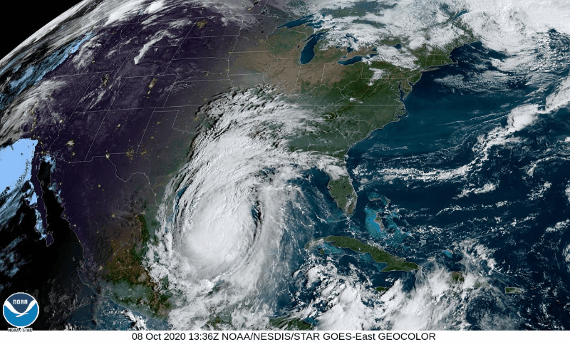
Hurricane “Delta” continues to churn to the NW over the Gulf of Mexico with a likely landfall late Friday in the southwestern part of Louisiana. Images courtesy NOAA
Overview
Hurricane “Delta” pounded the northeastern part of Mexico’s Yucatan Peninsula yesterday morning and its encounter with the land mass weakened the tropical cyclone from a category 4 “major” storm to a category 1. Since then, Hurricane “Delta” has moved out over the warm waters of the southern Gulf of Mexico into an area with more favorable atmospheric conditions and has re-intensified into category 2 status with maximum sustained winds of 105 mph. In this favorable environment with low vertical wind shear and deep moisture, Hurricane “Delta” could return to “major” hurricane status (i.e., category 3 or higher) as it churns towards a likely landfall late Friday in the southwestern part of Louisiana. After landfall, Hurricane “Delta” will weaken quickly, but its remnants will bring some significant rainfall to the Deep South, Tennessee Valley and as far north and east as the Mid-Atlantic region by the Sunday/Monday time frame.

Cooler-than-normal water in the northern Gulf of Mexico presents some hope that weakening can occur with Hurricane “Delta” in the hours before a likely landfall late Friday in the southwestern part of Louisiana. Map courtesy NOAA, tropicaltidbits.com
Details
Hurricane “Delta” is headed towards the southwestern part of the Louisiana coastline with a likely landfall late on Friday. This is the same region along the north-central Gulf coast that took a direct hit from Hurricane “Laura” earlier this tropical season during the middle part of August. In fact, the radar system in Lake Charles, Louisiana - hit hard by Hurricane “Laura” - is still down and this won’t make the forecasting job any easier in that area during the day on Friday. Indeed, the state of Louisiana has actually had three named storms (Cristobal, Laura and Marco) make landfall in the 2020 tropical season and “Delta” would be the fourth which would match 2002 (Bertha, Hanna, Isidore and Lili). The environmental conditions around Hurricane “Delta” are currently quite favorable for intensification with low vertical wind shear and deep moisture content and an “eye” is quite likely to form later today. As a result, there is a good chance that “Delta” returns to “major” hurricane status (i.e., category 3 or higher) during the next 12-24 hours – perhaps even back to its peak strength on Wednesday as a category 4 storm.

Total precipitation amounts will be quite high over the next 5 days as a result of Hurricane “Delta” in an area extending from the northern Gulf coastal region to the Mid-Atlantic. Map courtesy NOAA/WPC
One of the residual impacts of Hurricane “Laura” earlier this tropical season was the churning of the waters in the northern Gulf of Mexico and this “upwelling” resulted in colder water from underneath to rise up to surface level. The resultant cooler-than-normal waters in the northern Gulf hopefully can result in some weakening of Hurricane “Delta” as it heads towards a landfall in the north-central Gulf coastal region later tomorrow.

Hurricane “Delta” is likely to make landfall late Friday in the very same part of Louisiana that experienced a direct hit by Hurricane “Laura” in the middle of August. Map courtesy NOAA/NHC
After Hurricane “Delta” makes landfall, it will weaken quickly and become increasingly influenced by a developing mid-level trough over the south-central US which should cause it to turn to the northeast by tomorrow night or early Saturday and this will result in significant rainfall across the Deep South and Tennessee Valley. By the latter part of the weekend and early part of next week, the moisture field associated with the remains of Hurricane “Delta” is likely to push into the Mid-Atlantic region and this could result in a decent rainfall for the DC-to-Philly-to-NYC corridor.
There is a potential positive note to end on…it may turn quiet once again in the Atlantic Basin in terms of overall tropical activity following the departure of the remains of Hurricane “Delta” in the early part of next week.
Meteorologist Paul Dorian
Perspecta, Inc.
perspectaweather.com
Follow us on Facebook, Twitter, YouTube
Video discussion: