9:30 AM (Friday) | *Hurricane “Delta” to make landfall early this evening in the southwestern part of Louisiana…remnants to bring significant rain to the Deep South, Tennessee Valley, Mid-Atlantic*
Paul Dorian

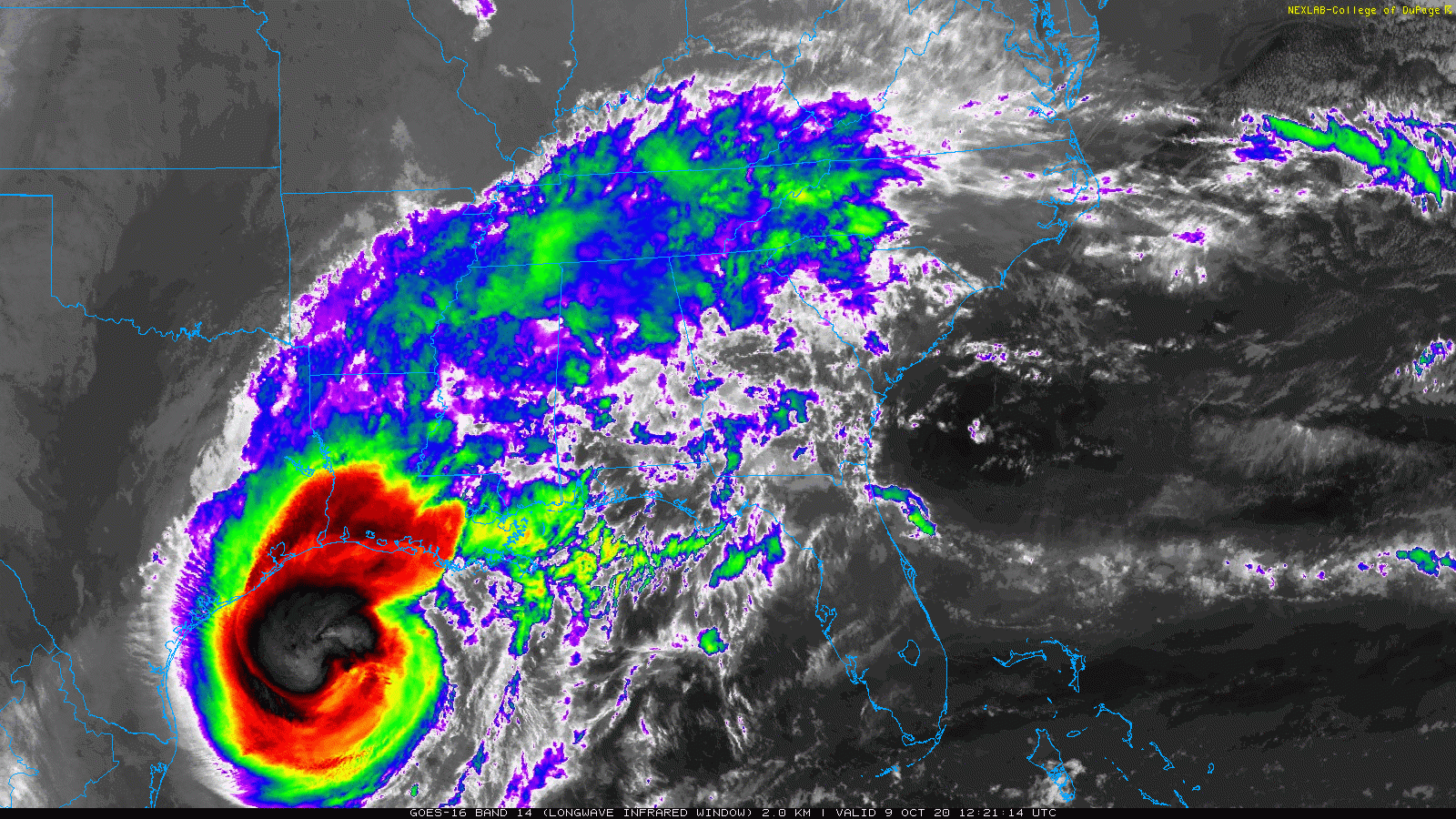
Hurricane “Delta” pushes to the north with a likely early evening landfall in the southwestern part of Louisiana. This will make the fourth landfall in the Bayou State this tropical season of a named system which hasn’t happened since 2002. Images courtesy College of DuPage, NOAA
Overview
Hurricane “Delta” is currently a category 3 “major” hurricane on its way for a landfall in southwestern Louisiana early this evening. There is a chance for some weakening of Hurricane “Delta” in the last few hours before landfall – perhaps from a category 3 to a category 2 storm – as it will push over cooler waters of the northern Gulf of Mexico. After landfall, Hurricane “Delta” will weaken quickly; however, its remnants will bring some significant rainfall to the Deep South, Tennessee Valley and as far north and east as the Mid-Atlantic region from Sunday into Monday.

Sea surface temperatures are cooler-than-normal in the northern Gulf of Mexico and this could lead to some weakening of Hurricane “Delta” in the last few hours before likely landfall later today. Map courtesy NOAA, tropicaltidbits.com
Details
Hurricane “Delta” intensified in the overnight hours into a category 3 “major” storm with maximum sustained winds of 120 mph. It has been rather steady in recent hours and has quite likely reached its peak strength as it will soon push over some cooler waters in the northern Gulf of Mexico. Landfall is likely early this evening in the southwestern part of Louisiana – just to the east of the Texas/Louisiana border and in nearly the same exact region that was hit directly by Hurricane “Laura” around six weeks ago in the middle of August. In fact, the radar system in Lake Charles, Louisiana - hit hard by Hurricane “Laura” earlier this tropical season - is still down today and won’t be of any help in the forecasting of Hurricane “Delta”, but no doubt, there will be torrential rain and powerful winds in the region from eastern Texas to southeastern Louisiana. With the expected landfall later today of Hurricane “Delta” in southwestern Louisiana, this would make four named storms in the state of Louisiana for this season including Cristobal, Laura and Marco and that hasn’t happened for the Bayou state since 2002 (Bertha, Hanna, Isidore and Lili).
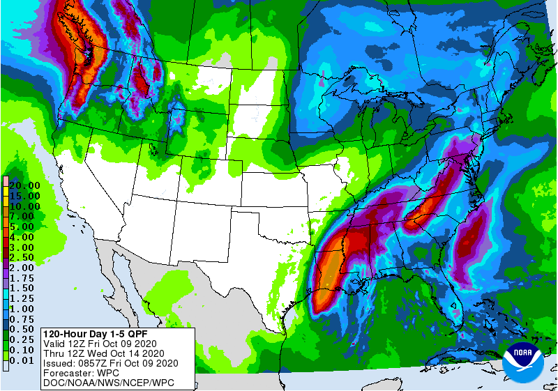
Once inland, Hurricane “Delta” will weaken rapidly; however, its remnants will result in some significant rain from the Deep South to the Tennessee Valley to the Mid-Atlantic region over the next few days. 5-day total precipitation amounts forecast map courtesy NOAA/WPC
One of the residual impacts of Hurricane “Laura” from earlier this tropical season is cooler-than-normal water across the northern Gulf of Mexico and this should lead to some weakening of Hurricane “Delta” in the hours just before landfall. There is hope that the now “major” hurricane with category 3 status can weaken to a category 2 storm later in the day. The cooler waters in the northern Gulf developed through the process of “upwelling” when Hurricane “Laura” brought colder water from deep down to the sea surface back in August.
After Hurricane “Delta” makes landfall, it will weaken quickly as is typical of tropical cyclones when their “fuel supply” is cut off (i.e., energy supplied by the warm waters underneath). Despite the weakening of Hurricane “Delta”, its remains will result in significant rainfall from the Deep South to the Tennessee Valley over the next couple of days. The center of the remains of Hurricane “Delta” will move to the northeast over the next couple of days as it becomes increasingly influenced by an upper-level trough to its north. The moisture field of the remains of Hurricane “Delta” will reach the Mid-Atlantic later in the weekend and result in a decent rainfall for the DC-to-Philly-to-NYC corridor from Sunday into Monday.

Multiple cold shots from Canada into the US in coming weeks will act to reduce the chances for tropical activity across southern and eastern states. Map courtesy NOAA, tropicaltidbits.com
There is a potential positive note to end on…it may turn much quieter for the southern and eastern US during the next few weeks in terms of overall tropical activity as multiple cold shots from Canada drop southeastward into the central and eastern US likely inhibiting any such action.
Meteorologist Paul Dorian
Perspecta, Inc.
perspectaweather.com
Follow us on Facebook, Twitter, YouTube
Video discussion: