
12:00 PM | *Significant storm to form just off the Mid-Atlantic coastline…heavy rain for I-95, coast…inland snows with interior New England the likely bulls eye region for heaviest snow*
Paul Dorian
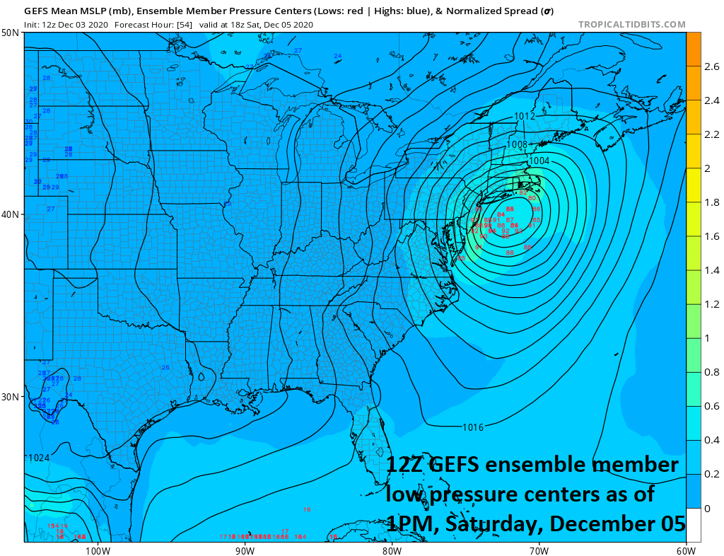
A consensus of “ensemble” members of the 12Z GEFS suggests that there will be a strong storm located off the Mid-Atlantic coastline by mid-day Saturday, December 5th. Map courtesy NOAA, tropicaltidbits.com
Overview
The major storm system that began the week in the Northeast US was the opening salvo in a colder and stormy weather pattern for much of the eastern half of the nation and another significant storm is in the offing for the early part of the weekend. Low pressure will pull out of the southern states on Friday and intensify as pushes to a position just off the Mid-Atlantic coastline by early Saturday. Rain is in the cards from this storm in the cities along the DC-to-Philly-to-NYC corridor and in areas to the coast; however, it will become cold enough for accumulating snow in higher elevation, interior locations of the Northeast US with the heaviest snowfall amounts likely coming to interior New England. There is an outside chance that it gets cold enough on Saturday in the I-95 corridor and coastal sections for the rain to briefly mix with or change to sleet and/or snow during the back end of the storm.

12Z GFS 500 mb forecast map on Friday afternoon features two separate waves of energy - one in the northern stream and one in the southern stream. These two systems phase together to form a strong and intensifying surface low pressure system that will be positioned off the Mid-Atlantic coastline by mid-day Saturday. Map courtesy NOAA, tropicaltidbits.com
Details
The major storm system that impacted the Northeast US, Ohio Valley, Great Lakes and Mid-Atlantic region on Monday occurred on the front end of an overall pattern change that will bring more persistent cold to the central and eastern US during the next couple of weeks and there will be continued storm threats as well including one during the early part of the upcoming weekend. The current upper air map features energy in the southern stream across the south-central states and a northern stream wave of energy is dropping southeastward across the Great Lakes. These two upper-level waves of energy will phase together by early Saturday and the result will be a strong and intensifying storm system located just off the Mid-Atlantic coastline as we begin the weekend.

12Z GFS 500 mb forecast map on Saturday afternoon features a “phased” together upper-level low centered just off the Mid-Atlantic coastline. Map courtesy NOAA, tropicaltidbits.com
In the latter part of the winter season, this kind of position of a surface low could produce accumulating snow in the big cities along the DC-to-Philly-to-NYC corridor; however, in this particular setup, there is no entrenched Arctic air in place supported by an anchoring high pressure system to the north. In addition, sea surface temperatures in the western Atlantic are still relatively warm and this makes it more difficult to get accumulating snows at this time of year in the immediate I-95 corridor. As a result, the main threat from this storm in DC, Philly, and NYC will be rain which can briefly mix with or change to sleet and/or snow on Saturday during the back end of the storm; especially, in some of the northern and western suburbs of NYC. Meanwhile, in higher elevations of the interior Northeast US, it is likely to be cold enough for accumulating snow in such places as the Poconos (PA), Catskills (NY) and especially interior sections of New England. In fact, the most likely region for the heaviest snowfall amounts on Saturday should extend from central/western Massachusetts-to-New Hampshire-to-Maine and this “heavy snowfall” threat zone could even end up stretching as far south as interior Connecticut.

12Z GFS surface forecast map on Saturday morning features a strong storm system over the Chesapeake Bay with heavy rainfall amounts from central Virginia to southern New Jersey. Map courtesy NOAA, tropicaltidbits.com
Following this storm, the weather will stay on Sunday in the northeastern quadrant of the nation and then we’ll have to be monitor two new strong waves of energy in the upper atmosphere - one will be dropping southeastward from Canada and the other pushing to the northeast from the Gulf of Mexico. These upper-level systems are likely to spawn a surface storm near the east coast on Monday which could produce snow or snow showers in parts of the Mid-Atlantic region - something else to closely monitor in this colder and stormy weather pattern.

12Z GFS surface forecast map on Saturday evening features a strong storm system off the New England with heavy snow (dark blue) falling across interior sections. Map courtesy NOAA, tropicaltidbits.com
Meteorologist Paul Dorian
Perspecta, Inc.
perspectaweather.com
Follow us on Facebook, Twitter, YouTube
Video discussion: