9:30 AM (Thursday) | ****Major rain event now underway in the eastern US…wind is an important factor as well…watch for localized flash flooding****
Paul Dorian

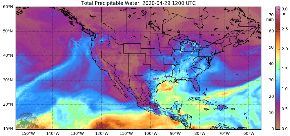
Tropical moisture is fueling this heavy rain event in the eastern US and is flowing northward from the Gulf of Mexico, SW Atlantic, and Caribbean Sea (total precipitable water loop). Courtesy University of Wisconsin/CIMSS; NOAA
Overview
Tropical moisture is flowing northward into the eastern US from the Gulf of Mexico, southwestern Atlantic, and the Caribbean Sea. This influx of tropical moisture is combining with a painfully slow-moving frontal system and a vigorous wave of energy in the upper atmosphere to fuel a widespread area of heavy rain that extends from Florida to the Northeast US. The heavier and steadier rain has moved into the DC metro region and should arrive in Philly this afternoon and New York City by this evening. The potential exists for as much as 1.5 - 3.0 inches of rain in much of the eastern US between now and mid-day Friday. Flash flooding will become an increasing concern given the heavy rainfall and the already pretty well saturated grounds. Winds will also be an important factor with this storm system as gusts could easily pass 50 mph in some spots; especially, near and along coastal regions - watch for power outages.

Bands of heavy rain extend this morning from Florida to the Northeast US/Great Lakes. Map courtesy University of Wisconsin, NOAA
Details
Tropical moisture is flowing northward this morning along the eastern seaboard and it has combined with a slow-moving frontal system to generate a widespread area of rain and thunderstorms in the eastern US. This area of rain has edged its way into the DC metro region and will slowly advance to the northeast over the next several hours reaching the Philly metro around mid-afternoon and then to NYC by early evening. There is a strong wave of energy in the upper atmosphere this morning supporting this storm system and it is located over the northern Ohio Valley. This system will be forced to drop to the southeast over the next 24 hours by a blocking pattern in the upper part of the atmosphere over the southern part of Canada. As a result, weather conditions will remain very unsettled on Friday in the Mid-Atlantic region with additional showers likely and perhaps a few thunderstorms as well.

An upper-level wave of energy will be forced to the southeast over the next 24 hours due to a blocking pattern in the upper atmosphere over southern Canada. This system will drop to the southeast from the northern Ohio Valley to the Mid-Atlantic between now and mid-day on Friday. Maps courtesy NOAA, tropicaltidbits.com
There is a growing concern for localized flash flooding in many parts of the eastern US over the next 24 hours or so given the expectation of 1.5 - 3.0 inches of rain and already pretty well saturated grounds due to recent rains. In addition, wind will be an important factor during this event with gusts to 40-50 mph in inland locations and 50-60 mph along coastal sections (e.g., New Jersey, Delmarva Peninsula) - watch for power outages. After the unsettled day on Friday, the good news is that the weekend should get off to a pretty decent start in the Mid-Atlantic following early morning clouds on Saturday with some sunshine and mild conditions. However, the next system will rapidly approach on Sunday and it is likely to produce more shower activity by late Sunday and Sunday night.

This major storm system extends all the way from southeastern Canada to the Gulf of Mexico. Image courtesy NOAA/GOES-16
Looking ahead, the overall active weather pattern is likely to continue in the eastern US for the next couple of weeks partly as a result of continued cold air outbreaks into the central and eastern states from central Canada. These cold air outbreaks are combining with increasingly warm and humid air across the southern US to not only help to produce storm systems in the eastern half of the nation, but they are also contributing to severe weather outbreaks in the southern states with another one possible early next week.
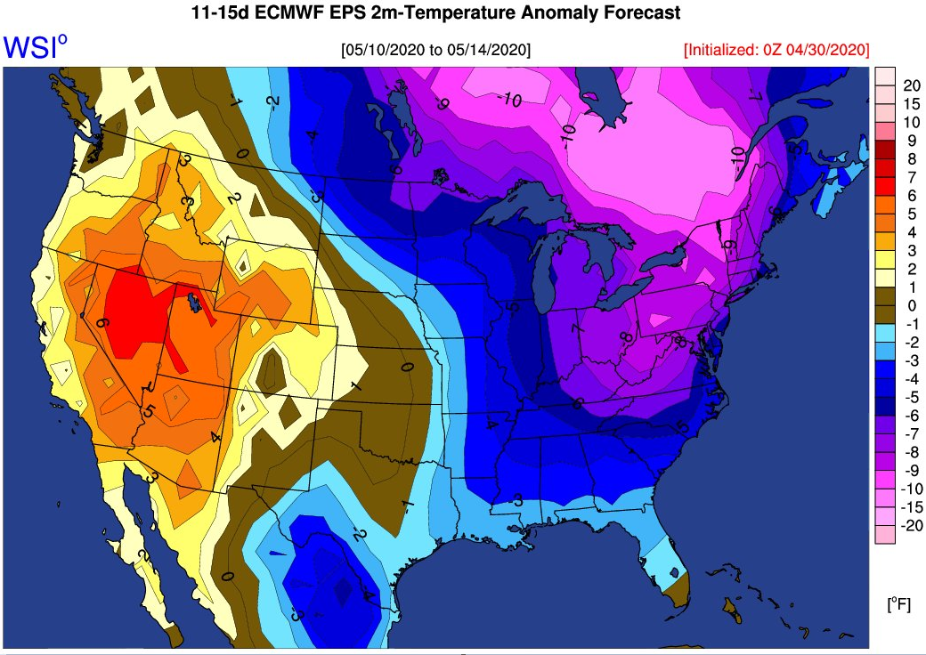
Colder-than-normal pattern continues in the Mid-Atlantic/NE US into the middle of May. Map courtesy WSI, Inc., ECMWF
Meteorologist Paul Dorian
Perspecta, Inc.
perspectaweather.com
Follow us on Facebook, Twitter, YouTube
Video discussion: