12:50 PM (Wed.) | **Tropical wave reaches the Caribbean Sea...could impact Florida this weekend…moisture from the likely-to-be-named “Isaias” may ride northward along the east coast early next week**
Paul Dorian

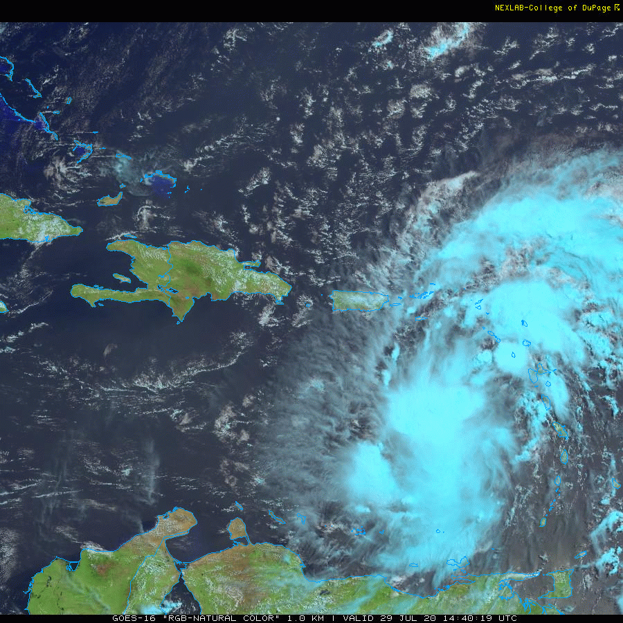
Latest satellite imagery shows a couple areas of deep convective surrounding tropical wave #9 as it continues on a WNW track. Images courtesy NOAA/GOES-16, College of DuPage
Overview
The 2020 Atlantic Basin tropical season has gotten off to an active start with eight named storms already and another wave that has reached the Caribbean Sea is quite likely to become the ninth (“Isaias”). This latest tropical wave pushed off the west coast of Africa late last week and had somewhat limited intensification possibilities over the past few days as it battled with dry air in the central Atlantic that originated over the Sahara Desert region of northern Africa. As such, the tropical wave appeared rather elongated and disorganized yesterday morning, but has since “escaped” the dry air mass and is now becoming better organized. There is a good chance that this system will reach tropical storm status in the next 24 hours and continue on a west-to-northwest track which will result in an impact on the northern Caribbean islands of Puerto Rico, Hispaniola and Cuba as well as the Bahamas.
After that, the tropical system may very well impact Florida by later Saturday, but its intensification prospects beforehand may be somewhat limited due to its possible interaction with these islands and a possible increase in southwesterly wind shear. By early next week, the tropical system could begin to take a more northerly track as it interacts with an unusually strong upper-level trough that will be “digging” into the south-central US and slowing down in its eastward progression. As a result, its moisture field could very well ride northward along the east coast in the early part of next week - potentially resulting in a significant rain event all the way from Florida to the Northeast US.

An unusually strong upper-level trough will “dig” into the south-central states later this weekend and early next week and will play a role in the ultimate path of tropical wave #9. Map courtesy NOAA, tropcialtidbits.com
Details
At 11 AM, tropical wave #9 has maximum sustained winds of 45 mph and continues to move along at a good pace (23 mph) in a west-to-northwest direction (290 degrees). High pressure ridging to the north over the western Atlantic Ocean should continue to steer the system in a similar direction over the next couple of days. On the current track, tropical wave #9 will impact Puerto Rico later today and tonight and then move to near or over the island of Hispaniola (Haiti/Dominican Republic) on Thursday and then to near eastern Cuba and the Bahamas by Friday. An interaction with the island of Hispaniola can certainly limit the chances for intensification of the tropical system - at least on a temporary basis - as there is rather mountainous terrain there with peaks above 10,000 feet. [High terrain can disrupt the overall circulation pattern surrounding a tropical cyclone limiting its intensification potential]. After that, the tropical system is likely to interact with the island of Cuba where there is some mountainous terrain and also the Bahama Islands. In addition, some computer forecast models suggest low-level southwesterly wind shear will increase late in the week in that region and this would act as an inhibiting factor for strengthening.

A rather wide range of storm tracks are depicted here by the individual ensemble runs of the 00Z Euro. The wide range of track solutions is likely the result of the lack of a well-defined center at this time for tropical wave #9. Map courtesy ECMWF
Latest satellite imagery shows no well-defined circulation with tropical wave #9, but deep convection can be seen in both the northeastern quadrant and southwestern quadrant. This “split” of the convection actually presents a forecasting dilemma in the sense that it suggests the circulation center could end up on the northern side or the southern side of the system and that difference in location can have an important effects on the eventual storm track and on the prospects for intensification. (If the northern area of the system becomes dominant then the prospects for an important impact would grow for Puerto Rico, Bahama Islands, Florida and the US east coast whereas if the southern part of the storm becomes more dominant then the system could take a more southern route and interact more directly with Hispaniola and Cuba]. One thing to note is that there is now very moist air surrounding this tropical system. This suggests that even if the tropical wave does not “climb” to hurricane status, it can still produce some very heavy rainfall amounts over these northern Caribbean islands and perhaps Florida and the eastern seaboard of the US.

A possible significant rain event in the eastern US during the early part of next week as moisture associated with tropical wave #9 could push northward ahead of an upper-level trough. Map courtesy NOAA/WPC
Looking ahead, there is a decent chance that this tropical wave reaches the Bahama Islands and the Florida Peninsula by the second half of the weekend. Heavy rainfall is definitely on the table from this system for the Bahamas and at least parts of Florida, but it remains to be seen how impactful the winds will be as it’ll depend on its intensification over the next few days. By the latter part of the weekend, this system will begin to interact with an unusually strong upper-level trough that will be “digging” into the south-central US and slowing down in its progression to the east. As a result, the tropical system could begin to take a more northerly track and its moisture field could very well ride up along the US east coast in the early part of next week - potentially resulting in a significant rain event all the way from Florida to the Northeast US.
Stay tuned…until a well-defined center emerges, there will be lots of detail unable to be ironed out.
Meteorologist Paul Dorian
Perspecta, Inc.
perspectaweather.com
Follow us on Facebook, Twitter, YouTube
Video discussion: