11:15 AM (Thurs.) | ***Tropical Storm Isaias to significantly impact the Bahamas and take a track towards the east coast of Florida…its moisture field could then push north up along the east coast***
Paul Dorian

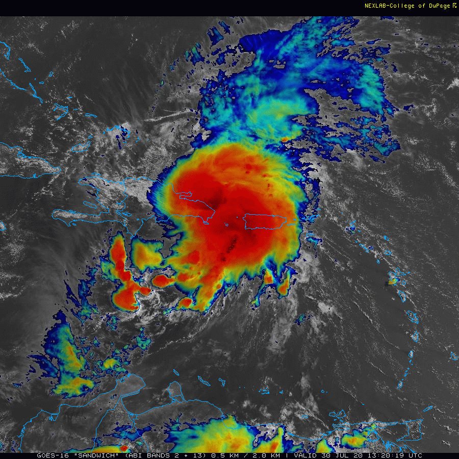
Tropical Storm “Isaias” is currently interacting with the islands of Hispaniola and Puerto Rico and is taking a track to the northwest at 20 mph. Imagery courtesy NOAA/GOES-16, College of DuPage
Overview
The 2020 Atlantic Basin tropical season has gotten off to a very active start now with nine named storms - the newest one being “Isaias”. Tropical Storm “Isaias” has been pounding away at Puerto Rico since last night with torrential rainfall and is now interacting with the island of Hispaniola (Haiti/Dominican Republic). This particular island has mountainous terrain with peaks of over 10,000 feet and it is likely to limit the intensification of “Isaias” – at least in the short-term. In addition, an interaction with this northern Caribbean island frequently causes a “re-positioning” of the low-level circulation center of a given tropical cyclone so we’ll look for that to take place over the next 12-24 hours. After that, Tropical Storm “Isasis” is likely to significantly impact the Bahama Islands - perhaps as a hurricane - and likely take a track over or just off the east coast of Florida with substantial rainfall and strong winds on the table. There is a chance that the moisture field of the tropical storm then rides up along the southeast US coastline to the Carolinas - and potentially as far north as the Mid-Atlantic/Northeast US.

A compilation of computer forecast model predicted storm tracks for Tropical Storm “Isaias” in coming days. Map courtesy weathermodels.com (Dr. Ryan Maue, Twitter, NOAA), UKMET, CMC)
Details
At 11 AM, Tropical Storm “Isaias” has a central pressure of 1003 millibars, maximum sustained winds of 60 mph and continues to move along at a pretty good clip in a northwesterly direction at 20 mph. The latest water vapor imagery indicate very high levels of moisture now surround the storm resulting in torrential rainfall for impacted areas such as Puerto Rico and the Dominican Republic. The interaction of “Isaias” with the mountainous terrain of Hispaniola will likely halt its intensification – at least in the short-term. The overall circulation of a given tropical cyclone is usually disrupted by the high peaks of the island that peak at over 10,000 feet. In addition to its impact on intensity of tropical cyclones, the island of Hispaniola often has a strange impact on low-level circulation centers. There is a tendency for circulation centers to “re-position” or “take a dance” around the island and avoid “cutting” directly across the island. Many past tropical storms in this location have re-formed on the north side of the island of Hispaniola which would put it in a position to significantly impact the Bahama Islands and perhaps eastern Florida.

Sea surface temperatures are plenty warm enough to support the growth of a hurricane in the southwestern part of the Atlantic Ocean. Map courtesy weathermodel.com (Dr. Ryan Maue, Twitter), NOAA
The impact in the Bahamas and eastern Florida is quite likely to be important in terms of rainfall amounts, but the overall impact of the winds will be determined by the intensification (or not) of the tropical system once it bypasses Hispaniola. There is certainly a chance that “Isaias” could strengthen into a hurricane once it gets past Hispaniola and out over the relatively open and warm waters of the southwest Atlantic. This potential scenario would, of course, increase the chances for damaging wind gusts in the Bahamas and perhaps in part of Florida as well as “Isaias” passes over or nearby this weekend. Ocean surface temperatures in the southwest Atlantic Ocean are plenty warm enough to support a hurricane as we approach the month of August with some spots hovering near 30°C.

The potential exists for a significant rain event all the way from Florida to the Northeast US as a result of Tropical Storm “Isaias”. 7-day total precipitation forecast map by NOAA’s Weather Prediction Center.
By the latter part of the weekend, Tropical Storm “Isaias” will begin to interact with an unusually strong upper-level trough that will be “digging” into the south-central US and importantly, it will be slowing down in its progression to the east. As a result, the moisture field of Tropical Storm “Isaias” will have the opportunity to ride up along the southeastern US coastline early next week on the front side of the deepening and very slow-moving upper-level trough. Beyond that, there is even a chance that significant rainfall extends all the way up to the Mid-Atlantic/Northeast US in the Monday/Tuesday time frame, but it is still a bit too early on those prospects.

The “official” storm track is shown here by NOAA’s National Hurricane Center as of 11AM Thursday. Map courtesy NOAA/NHC
Stay tuned…the interaction of “Isaias” with the island of Hispaniola in the near-term will have a lot to say about its future. One final note, yet another tropical wave now over the eastern Atlantic Ocean could very well have an impact on the US down the road as this active 2020 Atlantic Basin tropical season looks like it will continue into August and beyond….if it becomes a new named tropical storm, it would be “Josephine”.
Meteorologist Paul Dorian
Perspecta, Inc.
perspectaweather.com
Follow us on Facebook, Twitter, YouTube
Video discussion: