2:15 AM (Thursday) | *Now monitoring troublesome tropical system in the Gulf of Mexico and “major” Hurricane Teddy*
Paul Dorian

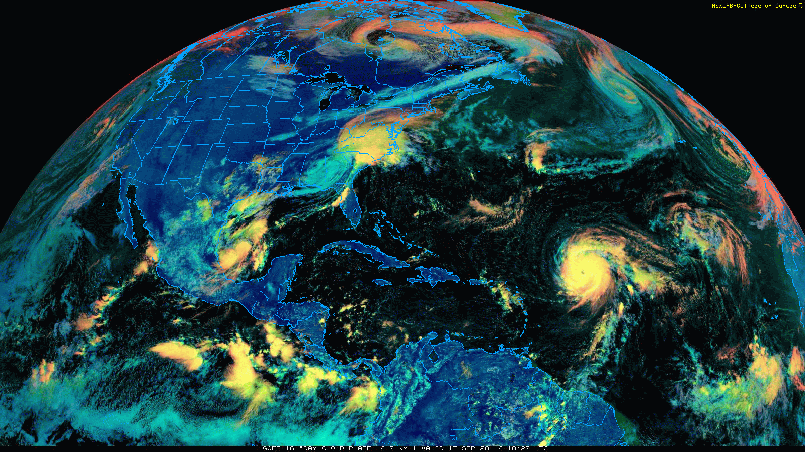
The remains of Hurricane Sally can be seen in this satellite imagery loop over the Southeast US/Mid-Atlantic region. In addition, a strong tropical wave is seen spinning over the southwestern Gulf of Mexico and Hurricane Teddy has a well-defined “eye” over the central Atlantic. Imagery courtesy College of DuPage, NOAA
Overview
While the remnants of Hurricane Sally produce heavy rainfall today from the Southeast US to the Mid-Atlantic, attention is shifting to two other tropical systems of concern. One tropical system has been meandering over the warm waters of the southwestern Gulf of Mexico in recent days and it looks like it will continue to do so for the next few days. As a result, it is very likely to soon intensify into named tropical storm status (would be called “Wilfred”) and it could ultimately have an impact pretty much anywhere on the Gulf coast from Texas to Florida. Meanwhile, Teddy has become a major hurricane over the central Atlantic and it is likely headed to near the island of Bermuda over the next few days. After that, the storm track forecast gets more complicated for Hurricane Teddy as it will encounter a blocking pattern in the upper atmosphere with strong high pressure ridging over southeastern Canada and an upper-level trough over the Canadian Maritime Provinces. It is unclear as to whether this interaction will cause a turn to the northwest and perhaps towards northern New England/Southeastern Canada or if Hurricane Teddy will goes harmlessly out into the North Atlantic.

Hurricane Teddy is now a “major” hurricane over the central Atlantic and the strong tropical wave over the SW Gulf of Mexico may very well become Tropical Storm “Wilfred” in the near-term. Map courtesy NOAA/NHC
Gulf of Mexico tropical system
A well-defined low pressure system has been parked over the warm waters of the southwestern Gulf of Mexico in recent days and the overall environment will become more conducive to intensification in the near-term. As a result, this tropical wave could very well become a tropical depression and then a named tropical storm, Wilfred, in the near-term and perhaps eventually a hurricane. By the way, Wilfred is the last actual name in this year’s list of Atlantic Basin hurricane names so the Greek alphabet would then be used in the same way it was during the last extremely active year of 2005.
This low is likely to meander in its current general location over the next day or so as it becomes a named tropical storm and then it may make a bit of a move to the north or northeast. As a consequence, this system could impact the Gulf coastal region by the middle of next week pretty much anywhere from Texas to Florida. Much of the Gulf coastal region has been pummeled recently with heavy rainfall so any threat of additional heavy rainfall from a tropical system obviously raises some concern.

The overall upper air pattern becomes somewhat complicated by early next week with high pressure ridging over eastern Canada and an area of low pressure over the NW Atlantic. The storm track of Hurricane Teddy beyond its close encounter with Bermuda will be largely dictated by its interaction with these two upper-level features. Map courtesy NOAA, tropicaltidbits.com
Hurricane Teddy
Hurricane Teddy has reached category 3 (i.e, major) status becoming the second major hurricane of the 2020 season (the other being “Laura”). Its overall appearance has steadily improved in recent hours and now has maximum sustained winds of 120 mph with a NW movement at 12 mph. Despite the fact that there is some vertical wind shear in its vicinity, additional intensification is likely meaning it could actually reach category 4 status by later tonight. As Hurricane Teddy continues to move on a northwest track over the weekend, it is likely to move over some cooler waters that was “upwelled” by Hurricane Paulette passing overhead and this could cause some weakening as it nears the island of Bermuda. Hurricane Teddy is likely to make its closest approach to Bermuda late Sunday or Monday and then its storm track forecast becomes more muddled.
During the early part of next week, high pressure aloft will build across southeastern Canada at the same time an upper-level area of low pressure will drop into the Northeast US/NW Atlantic. The interaction between these two upper-level features and Hurricane Teddy could result in a movement shift from a northerly direction to northwesterly and this could allow the storm to head towards Nova Scotia or Maine or other nearby regions – just a bit too early to say. There will be an impact along the Mid-Atlantic and Northeast US coastlines as early as this weekend with respect to an increasing rip current threat as a result of Hurricane Teddy.
Stay tuned.
Meteorologist Paul Dorian
Perspecta, Inc.
perspectaweather.com
Follow us on Facebook, Twitter, YouTube
Video discussion: