
1:00 PM (Fri) | *Get out the Greek alphabet…”Wilfred” has been taken…Hurricane Teddy to effect Bermuda then it may directly impact Nova Scotia…Gulf system continues to meander...a threat for Texas*
Paul Dorian

Hurricane Teddy continues to push to the northwest over the central Atlantic now classified as a “major” category 4 storm. The newest player on the tropical scene is Tropical Storm Wilfred in the eastern Atlantic. Images courtesy NOAA
Overview
Tropical Storm Wilfred has formed in the eastern Atlantic and that has now exhausted the list of hurricane names for the 2020 Atlantic Basin tropical season. As a result, the Greek alphabet will be used from here on out with the next named system to become “Alpha” and this may be the tropical wave that has been meandering over the western Gulf of Mexico in recent days. The last time the Greek alphabet had to be used for the naming of tropical storms was the very active year of 2005. Meanwhile, Hurricane Teddy has intensified into a category 4 “major” storm over the central Atlantic and it will likely effect Bermuda late in the weekend and then it may have a direct impact on Nova Scotia, Canada as an unfolding blocking pattern in the atmosphere changes its course.

This chart put together by the Philadelphia National Weather Service shows the path of all the named systems this season from “A” for Arthur to “V” for “Vicky” with the first letter of the given name showing the location of where the system dissipated. Note - map does not include “W” for “Wilfred”. Courtesy NOAA/NWS
Discussion
Get out the Greek alphabet. Tropical Storm “Wilfred” has formed in the eastern Atlantic and this exhausts the names on the 2020 Atlantic Basin list. As a result, the next tropical system to be named – perhaps the one currently meandering over the western Gulf of Mexico – will have to use “Alpha” from the Greek alphabet and then “Beta”, etc. The last time the Greek alphabet was used in the naming of Atlantic tropical storms was in the very active year of 2005. The strong tropical wave over the western Gulf of Mexico is likely to make a move towards the Texas coastline by the early part of next week as a named tropical storm or perhaps even as a hurricane.

Hurricane Teddy is likely to be moving in a north-to-northeast direction by later in the weekend as an upper-level low pressure system to its north (shown in blue) has an influence. By Tuesday, the upper-level low will be gone and blocking high pressure (shown in orange) will extend all the way from the central US to the North Atlantic. This blocking high pressure will cause an important shift in the movement of Hurricane Teddy from north-to-northeast to northwest. Maps courtesy NOAA, tropicaltidbits.com
Meanwhile, Hurricane Teddy has reached category 4 (i.e, major) status and the second major hurricane of the 2020 season with the other being “Laura”. Its overall structure has had little change since early this morning with an “eye” that has been partially filled at times. The latest measurements of Hurricane Teddy feature maximum sustained winds of 130 mph, movement to the NW at 12 mph, and a central pressure of 27.96 inches (947 millibars). Hurricane Teddy will continue to move on a general northwest track over the weekend and it will come close to the island of Bermuda late on Sunday or early Monday. It may actually weaken some later in the weekend as it is likely to move over some cooler waters that developed through “upwelling” after Hurricane Paulette passed over the same part of the Atlantic several days ago. After the effect on Bermuda by Hurricane Teddy, its storm track becomes a bit more uncertain as it will become increasingly influenced by blocking high pressure over Canada and the North Atlantic.

Tropical Storm “Wilfred” has formed in the eastern Atlantic and Hurricane “Teddy” continues to churn in the central Atlantic - now as a category 4 “major” storm. Elsewhere, tropical depression #22 in the western Gulf of Mexico is likely to become a named tropical storm in coming days and the Greek alphabet would have to be used. Map courtesy NOAA/NHC
During the early part of next week, high pressure aloft will build to the west and north of incoming Hurricane Teddy and the interaction between these two systems will likely cause a movement shift from north-to-northeast to northwest. This shift in the movement of Hurricane Teddy could allow the storm to head directly towards Nova Scotia, Canada by late Tuesday or Tuesday night. Ultimately, Hurricane Teddy could become “extra-tropical” and perhaps not a true hurricane, but the bottom line is that there can be a direct impact on Nova Scotia and perhaps some effect on Maine in northern New England and New Brunswick in the southeastern part of Canada.

Hurricane Teddy can have a direct impact on Nova Scotia, Canada by the middle of next week and potentially have an important effect on Maine in northern New England and New Brunswick in southeastern Canada. Map courtesy pinterest.com
Accumulated Cyclone Energy (ACE)
Interestingly, while the Atlantic Basin has had its most active tropical season since 2005, the Pacific Ocean has been quiet and well below-normal for the season. About 75% of all tropical cyclones form in the Pacific Ocean - the worlds largest ocean by far - and a below-normal Pacific Ocean in terms of tropical activity will almost unquestionably translate into a below-normal season for the Northern Hemisphere as a whole.
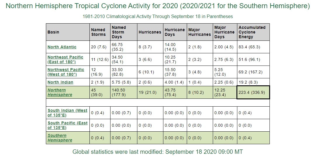
Accumulated Cyclone Energy (ACE) is a metric used to measure overall tropical activity which takes into account the strength and longevity of a tropical system. While the North Atlantic has featured an extremely high number of tropical storms this season and its ACE is above normal, the Pacific Ocean has been quiet in terms of overall tropical activity and its ACE is well below-normal (compared to the climatological average of the 1981-2010 base period). In addition, the ACE for the Northern Hemisphere is well below-normal (boxed in region) as the Pacific Ocean easily outweighs the North Atlantic in overall influence. Data courtesy Colorado State University/NOAA
One of the best ways to measure overall tropical activity is with a metric known as the “Accumulated Cyclone Energy” (ACE) which takes into account not only the number of tropical systems, but also the strength and longevity. Since ACE includes both the intensity and longevity of tropical systems, a long-lived tropical storm could contribute as much as a short-lived storm that reached hurricane intensity. While ACE is above-normal at this point in the season for the North Atlantic, it is well below-normal for the Pacific Ocean (Northeast, Northwest) and it is running at well below-normal levels for the Northern Hemisphere as a whole. One of the big factors likely leading to a below-normal tropical season in the Pacific Ocean and above-normal in the Atlantic Ocean is La Nina which is resulting in colder-than-normal in the equatorial part of the Pacific. A colder-than-normal sea surface in the equatorial Pacific Ocean tends to suppress tropical activity there and a La Nina pattern often results in less wind shear across the tropical Atlantic Ocean which tends to enhance tropical activity.

The coldest air of the season so far arrives today in the Mid-Atlantic/Northeast and it’ll stay well below-normal into early next week. Map courtesy NOAA, tropicaltidbits.com
Mid-Atlantic/Northeast US
There will be some impact by Hurricane Teddy this weekend in the Mid-Atlantic and Northeast US coastal regions with an increasing threat of rip currents and that threat will last well into next week. In addition, this same blocking high pressure system to our north that may ultimately influence Hurricane Teddy’s storm track will also have an impact in the Mid-Atlantic/Northeast US in terms of temperatures. Specifically, this high pressure system is anchoring a very chilly air mass for this time of year and temperatures will bottom out at the lowest levels so far this season during the next few nights with many suburban locations along the DC-to-Boston corridor experiencing the lower 40’s for overnight lows. In fact, frost is a threat for the next couple of nights in places like upstate Pennsylvania, interior New York and New England. In terms of precipitation, the blocking high pressure to our north will generate more dry weather for the Mid-Atlantic/Northeast US with little chance of rain well into next week.
Meteorologist Paul Dorian
Perspecta, Inc.
perspectaweather.com
Follow us on Facebook, Twitter, YouTube
Video discussion: