12:00 PM (Tuesday) ****Significant snow and/or ice on Thursday/Thursday night in DC-to-Philly-to-NYC corridor…historic cold continues across the central US…nationwide snow cover at a record high****
Paul Dorian

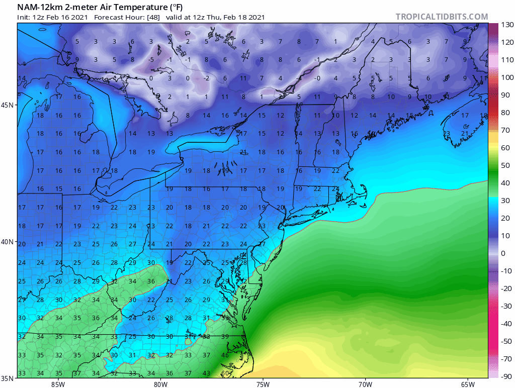
Surface temperatures will be hard-pressed to rise above the freezing mark in the DC-to-Philly-to-NYC corridor during the 24-hour period between 7AM Thursday and 7AM Friday. An entrenched cold air mass will allow for the buildup of snow and/or ice in much of the Mid-Atlantic region during this next winter storm event that can last into the day on Friday. Maps courtesy NOAA, tropicaltidbits.com
Overview
With the passage of one storm system in the overnight hours, attention to those in the Mid-Atlantic region will now turn to the next storm system and this one is likely to generate significant snow and/or ice for the DC-to-Philly-to-NYC corridor with several inches on the table. The next storm will take a track farther to the east compared to last night’s system and this will help to keep in place a cold air mass that arrives in the overnight hours. This cold air mass will be anchored by strong high pressure to the north and low-level temperatures are likely to remain at or below freezing during much of the upcoming event in the immediate I-95 corridor – virtually assuring a buildup of snow and/or ice.
Elsewhere, historic and dangerous cold continues today across much of the central US. Several sites have set their all-time low temperature records and many others have experienced their lowest temperatures ever recorded in the month of February. In addition to the extreme cold, snow and ice has accumulated all the way down to the Gulf coastal region of Texas. In fact, nearly three-quarters of the US is now covered by snow which is the highest amount ever recorded since this kind of data began to be collected in 2003.

12Z NAM forecast map for 10AM, Thursday, February 18th with snow (in blue) across PA, NJ, southern NY and just to the north and west of Washington, D.C. with sleet (in purple) in DC and points south and east. Map courtesy NOAA, tropicaltidbits.com
Winter storm threat for the Mid-Atlantic region
Last night’s storm system pushed northeastward during the past 24 hours from the southern US to the Ohio Valley. This kind of storm track resulted in a snowstorm across Ohio and Indiana and it allowed for slightly warmer air aloft to move into the DC-to-Philly-to-NYC corridor during the overnight hours which prevented any kind of serious icing event. The next storm, however, will end up in a position just off the Mid-Atlantic coastline and this kind of storm track will allow for an incoming cold air mass to remain in place on Thursday and Thursday night likely leading to a significant buildup of snow and/or ice. In addition to the more favorable storm track for frozen precipitation, strong high pressure will build across northern New England later Wednesday and this combination of a favorable storm track and a high to the north will likely inhibit temperatures from climbing above the freezing mark on Thursday and Thursday night in the DC-to-Philly-to-NYC corridor – and that spells trouble with lots of moisture headed this way.

A powerful jet streak in the upper part of the atmosphere late Thursday will combine with a low-level jet streak to generate strong upward motion near the Mid-Atlantic coastline and this is where low pressure will intensify. Map courtesy NOAA, tropicaltidbits.com
Snow is likely to break out in much of the Mid-Atlantic region on Thursday - likely in time to have an impact on the morning commute in much of the area - and it can come down hard for awhile. A changeover to sleet will likely take place from south-to-north later in the day, but several inches of snow are possible before this changeover takes place in much of the I-95 corridor. The combination of snow, sleet and/or freezing rain later in the day and on Thursday night with temperatures at or below freezing will allow for an icy buildup in many areas on top of the snow that does accumulate earlier in the event. The snow, sleet and/or freezing rain can continue into Friday making this a rather long duration event for the Mid-Atlantic region. Stay tuned…details still need to be ironed out including changeover times; however, the choice between accumulating snow or accumulating ice is not all that appealing.

Snow depth data across the nation has been collected on a regular basis since 2003. Nearly three-quarters of the nation is now covered by snow - including in the Gulf coastal region of Texas and Louisiana - and this is the highest amount since records began. Map courtesy NOAA
Historic cold continues…US snow cover at an all-time high
Historic cold continues today across the central US with several all-time low temperature records being set and numerous monthly records. A sampling of today’s all-time temperature records include the following sites (still unconfirmed):
Hastings, Nebraska (-30°F )
Beatrice Municipal, Nebraska (-29°F)
Tyler, Texas (-1°F)
Greenville, Texas (-2°F)

4.3 million residents of Texas are currently without power during this extreme cold event.
The temperature dropped to as low as -2°F in Dallas, Texas this morning (DFW Airport) and this is unofficially the second lowest temperature ever recorded there. There are about 4.3 million residents without power in Texas at this time suffering through this bitter cold weather and likely many won’t see restoration for several days. Snow accumulated all the way down to the Gulf coastal region of Texas and Louisiana with the sands at Galveston Beach, Texas, for example, covered by snow. In fact, snow now covers nearly three-quarters of the nation which is the highest ever recorded since this type of data began to be collected back in 2003.

Numerous central US locations experienced record or near record lows this morning. Map courtesy coolwx.com
Meteorologist Paul Dorian
Perspecta, Inc.
perspectaweather.com
Follow us on Facebook, Twitter, YouTube
Video discussion: