10:30 AM | *****Powerful hurricane threat continues for the northern Gulf coastal region in the late Sunday time frame…rapid intensification of “Ida” this weekend likely to result in a “major”*****
Paul Dorian

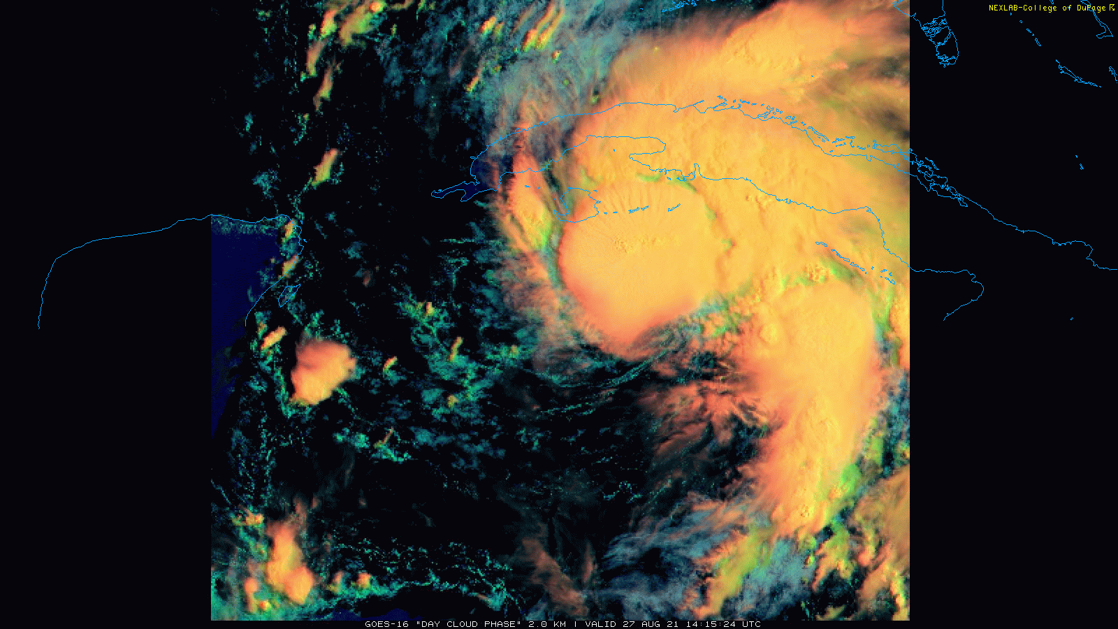
TS Ida is now closing in on the western part of Cuba as a strong tropical storm and will likely undergo rapid intensification this weekend over the open warm waters of the Gulf of Mexico. Images courtesy College of DuPage, NOAA
Overview
The Atlantic Basin remains active today with three systems on the tropical scene, but the one just to the south of western Cuba is of most concern at this time. There are strong signs that this system now officially known as “Tropical Storm Ida” will undergo rapid intensification this weekend once it gets past Cuba and out over the open warm waters of the Gulf of Mexico. The expected rapid intensification is likely to result in a “major” hurricane classification (i.e., category 3 or higher) of Ida before it makes landfall likely in the northern Gulf coastal region late Sunday or Sunday night. After landfall, the remnants of Ida will turn north initially and then to the northeast and tropical storm conditions could exist all the way into the Tennessee Valley. This post-landfall track would bring significant rainfall to the Tennessee Valley early next week – the last thing they need after recent flooding rains – and perhaps to the Mid-Atlantic region around mid-week.

Sea surface temperatures in the Gulf of Mexico are plenty warm enough to support rapid intensification of TS Ida this weekend and a “major” hurricane. Map courtesy tropicaltidbits.com, NOAA (actual temperatures left, anomalies right)
Details
There are two tropical systems currently out over the open waters of the Atlantic Ocean and both are likely to develop into named tropical storms; however, neither is a threat to land anytime soon. It is the third system now located to the south of western Cuba that is of most concern as it is very likely to undergo rapid intensification this weekend and could very well reach “major” classification (i.e., category 3 or higher) before a possible landfall late Sunday in the northern Gulf coastal region – perhaps the central Louisiana coastline. With a possible landfall in the northern Gulf coast, storm surge could be significant all the way to the Mobile Bay in southwestern Alabama.

With a possible landfall in central Louisiana as projected by some computer forecast models, storm surge could be significant all the way eastward to Mobile Bay in southwestern Alabama. Map courtesy NOAA (note-this is an experimental product of NOAA)
At 11 AM, Tropical Storm Ida was moving NW at 15 mph with maximum sustained winds around 65 mph – not all that far from category 1 hurricane status. TS Ida will move over the western part of Cuba in the near-term and it could strengthen just enough to be classified as a category 1 hurricane before that pass over. Once Ida bypasses Cuba later tonight, the rapid intensification phase is likely to begin. Environmental conditions will become very favorable for strengthening on Saturday as Ida travels over the very warm waters of the Gulf of Mexico and high pressure ridging builds across southeastern Canada.

Upper-level ridging will be strong over southeastern Canada this weekend and this is typically favorable for the intensification of tropical systems in the Gulf of Mexico. Map courtesy NOAA, tropicaltidbits.com
Sea surface temperatures are plenty warm enough in the Gulf of Mexico to support a hurricane – even a “major” hurricane – as long as atmospheric conditions are conducive and they should be in this case. In fact, water temperatures in much of the northwestern part of the Gulf of Mexico are 85 degrees (F) or higher which is actually well above-normal for this time of year.
In addition to water temperatures, a “supportive” factor for Ida will be the upper-air pressure pattern that is unfolding. In the upper part of the atmosphere, strong high-pressure ridging will set up over the southeastern part of Canada this weekend and this is usually a favorable position for tropical activity in the Gulf of Mexico (or southwestern part of the Atlantic). Computer forecast models support the idea for abnormally higher heights (and pressure) over the southeastern part of Canada and additional support for this comes from a teleconnection index known as the North Atlantic Oscillation or NAO. When this index is in “negative” territory for an extended period of time - as it is likely to be in coming days - the typical upper-air pattern that forms features strong high pressure over places like eastern Canada or Greenland.
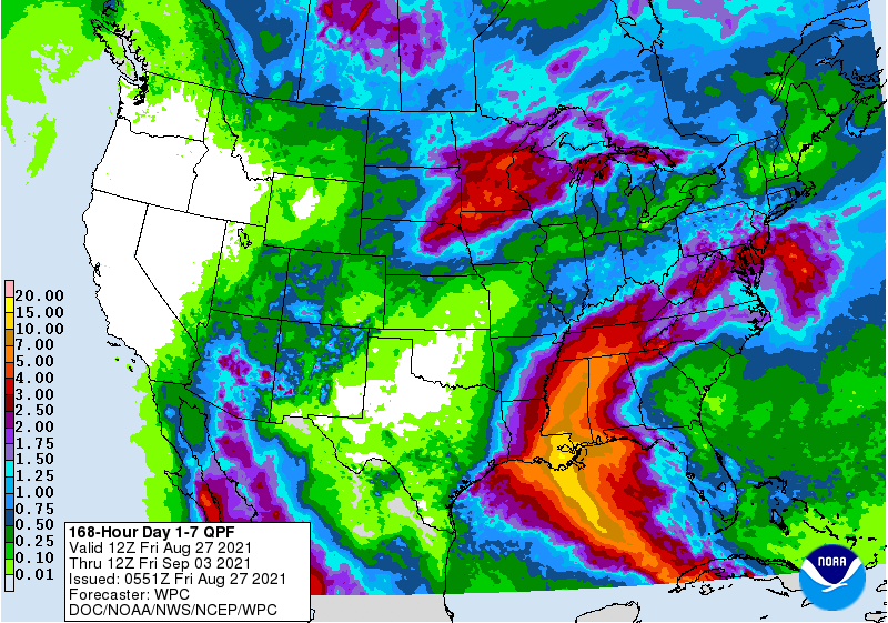
After landfall, the remnants of Ida will stay quite strong for awhile and likely turn to the north initially and then to the northeast. This kind of a post-landfall track would bring a swath of heavy rainfall to the Tennessee Valley early next week and perhaps to the Mid-Atlantic around mid-week. Map of total precipitation amounts for the next 7 days courtesy NOAA
After landfall, there is reason to believe the remnants of Ida will remain quite strong for awhile with tropical storm conditions possible all the way into the Tennessee Valley. The remnants of Ida will likely push to the north initially and then turn to the northeast later next week. This kind of a post-landfall track would bring more heavy rainfall to the Tennessee Valley – where they don’t need it – and perhaps to the Mid-Atlantic region around mid-week. All residents from the Florida Panhandle-to-Texas should continue to closely monitor Ida as it heads from the Caribbean to the Gulf of Mexico and a likely northern Gulf coast landfall later Sunday or Sunday night as a powerful hurricane.
Meteorologist Paul Dorian
Peraton
peratonweather.com
Follow us on Facebook, Twitter, YouTube
Video discussion: