
11:30 AM | ****Significant winter storm threat for the Mid-Atlantic/Northeast US later Sunday into Monday****
Paul Dorian

Many ingredients appear to be coming together for a significant storm late this weekend and one is an influx of tropical air with high moisture content. Map courtesy NOAA, tropicaltidbits.com
Overview
The chances are growing for a significant winter storm to impact the Mid-Atlantic/Northeast US from later Sunday into Monday. In fact, many ingredients appear to be coming together for a storm system that can have a high impact over a large area of the eastern third of the nation from later Sunday into Monday with snow, ice, rain, coastal flooding, and even high (damaging) winds on the table. There are many details that still have to be ironed out with several days to go before this potential event and the main upper-level wave of energy is way out over the Pacific Ocean. The I-95 corridor may be right on or near the dividing line between substantial snowfall to the north and west and a mix of rain, ice and snow to the south and east.

12Z GFS surface forecast map as of early Sunday evening featuring a wide-impacting storm system. Map courtesy NOAA, tropicaltidbits.com
Details
Numerous ingredients are likely to play a role in this potential late weekend significant storm system that include a vigorous upper-level disturbance that is currently located well out over the Pacific Ocean. This system will eventually drop southeastward into the southern states riding along in the southern branch of the jet stream. In addition, there will be an cold, dry and dense Arctic air mass in place this weekend across the Mid-Atlantic, Northeast US and southeastern Canada. Furthermore, a strong low-level jet will likely form at 850 millibars during this event and there will even be a tropical connection in the warm sector of the system that will provide an influx of air with very high moisture content.
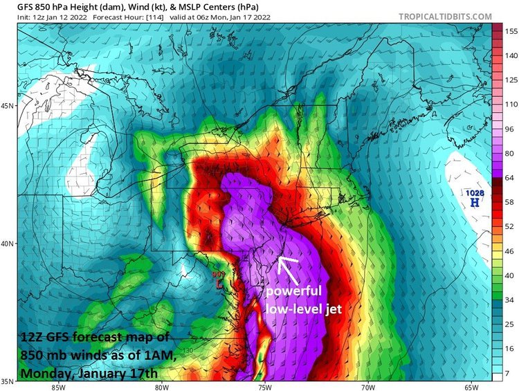
Another potential important part of this storm may be a very strong low-level jet streak (at 850 millibars). This possibility raises a red flag that this storm system could come with coastal flooding - given the onshore flow - and perhaps there can be some damaging wind gusts as well in some spots in the time period from late Sunday into Monday. Map courtesy NOAA, tropicaltidbits.com
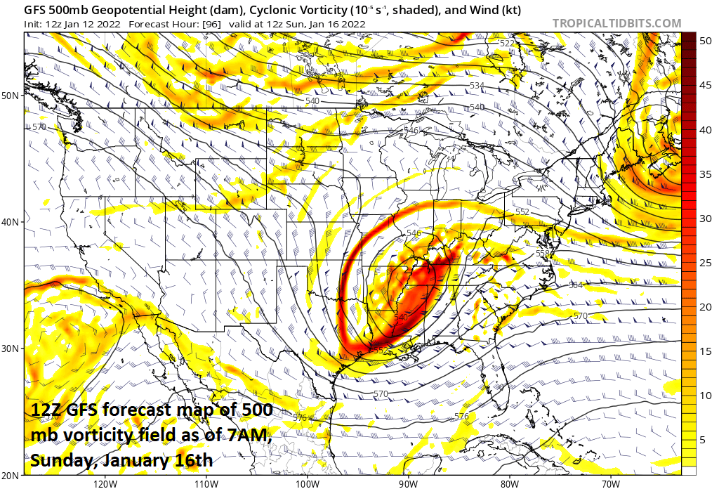
The stage will begin to get set on Saturday as a strong Arctic high pressure system builds into southeastern Canada anchoring a very cold, dry and dense air mass that will become entrenched in the Mid-Atlantic region and Northeast US. At the same time, a vigorous upper-level disturbance will push southeastward through the central Plains riding along in the southern branch of the jet stream. There will also be a second upper-level disturbance dropping southeastward in the northern branch of the jet stream and its interaction with the southern branch feature could end up being an important factor in this overall scenario.

One key player in the potential late weekend storm system will be a vigorous upper-level disturbance that will eventually move over the Mid-Atlantic. There will also be a second upper-level system off to its west and the interaction between the two may an important factor in the track of the surface storm. Map courtesy NOAA, tropicaltidbits.com
By early Sunday, the potent upper-level system in the southern branch of the jet stream will reach the Deep South and surface low pressure will begin to take shape in the southeastern part of the nation. This surface low will then make a move to the northeast and the Arctic high pressure will try to hold its ground across northern New England. Any low-level cold, dense air that will be in place on Sunday morning will likely be quite reluctant to give up its ground and this certainly enhances the chance for some frozen precipitation in the Mid-Atlantic/Northeast US during this upcoming event. Snow could break out in the DC-to-Philly-to-NYC corridor later in the day on Sunday as the surface system pushes to the north and east with front-end accumulations quite likely.
By early Sunday, a strong wave aloft will be pushing into the Deep South and this will help to generate surface low pressure in the southeastern states that will eventually push up to the north and east. Map courtesy NOAA, tropicaltidbits.com
It is at this point in time that remains unclear for now as to whether the storm will take somewhat of an inland track near or over Route I-95 or if it’ll ride up along the coastline. An inland track would likely result in a snow-to-ice-to-rain scenario in the I-95 corridor and points to the south and east. A track of the storm over or just to the east of the coastline, however, would allow for the possibility of a more substantial snowfall to fall in the immediate DC-to-Philly-to-NYC corridor. These all-important details will have to wait a bit longer to get ironed out; especially, considering the current location of a key player (i.e., upper-level disturbance) out over the Pacific Ocean.

The waves of energy that will become the catalysts for the late weekend storm system are still situated way out there over the eastern Pacific Ocean. Map courtesy NOAA, tropicaltidbits.com
Some final notes…given the likelihood of a moist tropical connection with this storm combined with a great overrunning surface of cold, dry, dense Arctic air to the northeast, it is quite likely that some portion of the Mid-Atlantic/Northeast US gets blitzed by heavy and potentially crippling snowfall (e.g., western Virginia, upstate Pennsylvania). Also, there is a tendency for low pressure systems to track along areas of “thermal gradients” such as right over the east coast during the middle of winter and this is something we’ll watch for in coming days. A temperature contrast naturally exists at the east coast this time of year given the relatively warm waters of the western Atlantic Ocean to the east and the cold ground conditions to the west. And finally, an inland track would certainly raise the possibility of coastal flooding; especially, given the chance for powerful southeast winds at the coastline for a portion of this event.
Stay tuned…it will be an interesting few days. And in a look beyond the storm, the overall weather pattern likely remains quite a bit colder-than-normal for much of the second half of the month.
Meteorologist Paul Dorian
Arcfield
arcfieldweather.com
Follow us on Facebook, Twitter, YouTube
Video discussion: