
11:30 AM | ***Potential is there for an intense ocean storm early this weekend...impact in the Mid-Atlantic will be dictated by the still to be fined-tuned storm track and intensification rate***
Paul Dorian

A deepening upper-level trough of low pressure over the eastern states will play an important role in the placement of the surface storm and its intensification rate. A “negatively-tilted” trough axis would allow for the storm to track close in to the east coast and a potential bigger impact in the Mid-Atlantic region. Map courtesy NOAA, Pivotal Weather
Overview
A cold and active weather pattern will continue this last full week of January across the eastern US and there is growing potential for an important ocean storm early this weekend. Any impact in the Mid-Atlantic region would likely be in the Friday night/Saturday time frame and it will largely depend on the ultimate track of the storm and its intensification rate. Many ingredients are going to come together at the end of the week that will allow for explosive intensification of surface low pressure including the following: jet streaks in the northern and southern branches of the jet stream, plenty of cold air to the north and west, and deepening low pressure aloft that takes on a “negative” tilt. At this time, it is just too early to tell if this ocean storm will track well off the coast, close in or perhaps even ends up taking a slightly inland track which is a scenario that is still on the table though not too likely. It certainly looks like it’ll be an interesting next few days as we track this growing threat.

Jet streaks in the upper part of the atmosphere will play key roles in the ultimate storm track and intensification rate on Friday night and Saturday. One jet streak will be riding along the northern branch of the upper-air wind flow and the other in the southern branch of the jet stream. Map courtesy NOAA, Pivotal Weather
Details
A weak low pressure system generated some snow shower activity in the Mid-Atlantic region late yesterday and another weak system can produce a bit of rain or snow on Tuesday. After that, strong Arctic high pressure will move in at mid-week and it’ll anchor another very cold air mass having its origins way up in northwestern Canada. In fact, Wednesday is likely to turn out to be one of the coldest days so far this season in the I-95 corridor with high temperatures doing no better than the 20’s and a stiff NW wind will produce mighty low wind chill values. Low temperatures by early Thursday morning will more than likely be near the 10 degree mark in the DC-to-Philly-to-NYC corridor…plus or minus a few degrees. At this point in time, all eyes will focus in on the eastern US and the possibility of a powerful western Atlantic Ocean storm in the Friday night/Saturday time frame.

Any potential late week storm will be preceded by another blast of Arctic air at mid-week making Wednesday one of the coldest days so far in the Mid-Atlantic region. Map courtesy NOAA, tropicaltidbits.com
By the late week, many ingredients will likely come together for the formation of low pressure near or just off the east coast and with the potential of explosive intensification. First, long-wave low pressure will start to deepen in the upper part of the atmosphere over the eastern US and this will be a key player in both the placement of the surface low pressure system and also in its intensification rate. In addition, strong ridging of high pressure will build aloft over two areas: the North Atlantic Ocean and the western US. Two jet streaks will become important factors as well with one of these dropping southeastward through the northern branch of the jet stream and another one pushing along in the southern branch.

Surface forecast map by the 12Z Canadian computer forecast model for 7AM, Saturday, January 29th. Map courtesy Canadian Met Centre
If the upper-level low pressure trough axis over the eastern states can take on a slightly “negative” tilt (i.e., oriented from northwest-to-southeast) then the surface low pressure system can deepen rapidly close to the east coast leading to more of an impact in the Mid-Atlantic region. In fact, there are some signs that intensification can be explosive with this early weekend system with a tremendous drop in central pressure predicted by the latest European model run in the 24-hour period between mid-day Friday and mid-day Saturday. In fact, the 12Z Euro drops the central pressure by an amazing 55 millibars in this 24-hour time period as all of the aforementioned ingredients come together.
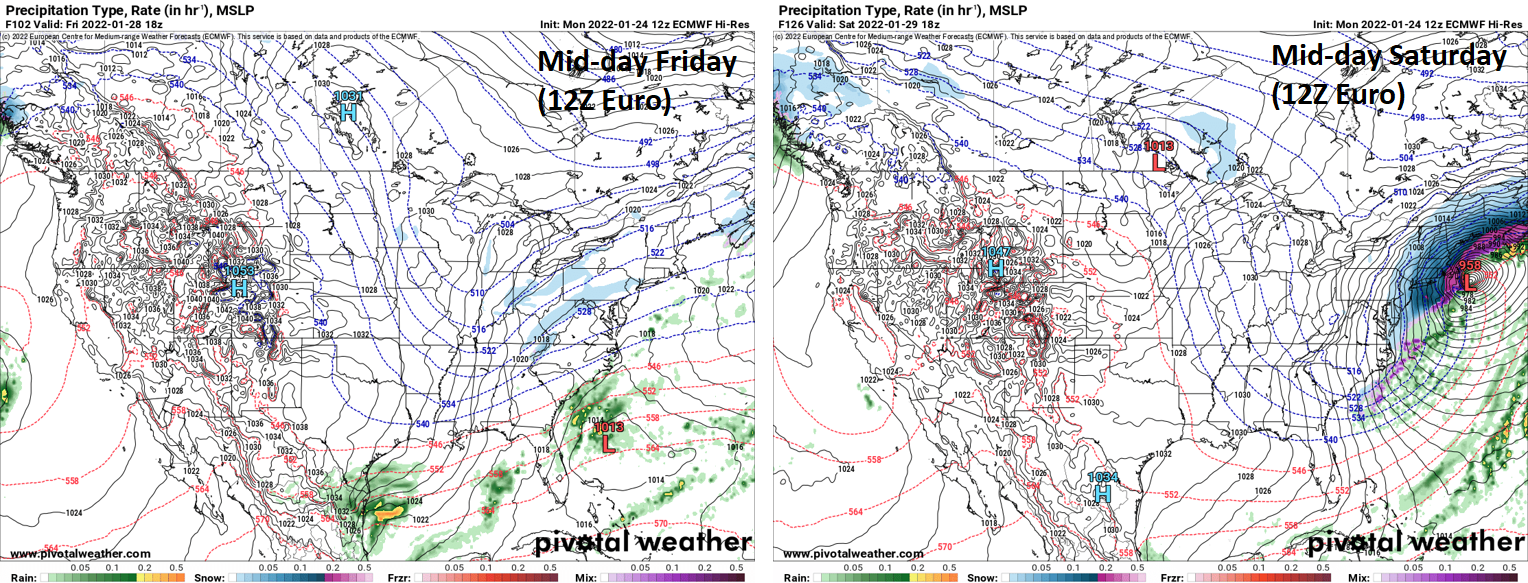
12Z Euro has an explosive intensification of the late week/early weekend storm with a drop of 55 millibars between mid-day Friday (left) and mid-day Saturday (right). Maps courtesy ECMWF, Pivotal Weather
If on the other hand, the “negative” tilt doesn’t happen until out over the western Atlantic Ocean then the storm would likely end up intensifying well off the coast with less of an impact in the Mid-Atlantic region. There is a third possibility as well though I think it is less likely to occur compared to either of the other two. If the “negatively-tilted” trough axis actually develops sooner-than expected then the surface low can actually take a slightly inland track - perhaps over the I-95 corridor as which occurred earlier this season. In the very least, an inland track would raise the chances of mixed precipitation or rain in places like southern and eastern New England and the coastal Mid-Atlantic. The trend with some recent storms in terms of the storm track and location of highest intensification has been “too far east” for significant impacts in places like Philly and New York City, but that past performance doesn’t guarantee it’ll happen again this time…stay tuned…an interesting next few days.
Meteorologist Paul Dorian
Arcfield
arcfieldweather.com
Follow us on Facebook, Twitter, YouTube
Video discussion: