12:00 PM | ***TS Nicole headed towards east-central Florida…can reach hurricane status…major rain event from Florida-to-Maine…severe weather threat in coastal plain…cold pattern begins this weekend***
Paul Dorian
Tropical Storm Nicole is getting better organized and can reach hurricane status of category 1 or even 2 before a likely landfall early Thursday in east-central Florida. Images courtesy NOAA/GOES-East
Overview
Tropical Storm Nicole is headed towards east-central Florida for a likely landfall early Thursday morning. Some intensification is likely during the next 24-36 hours before landfall which could result in Nicole reaching category 1 or even 2 hurricane status before making landfall. After landfall, Nicole will be increasingly influenced by a deep upper-level trough over the central states and it’ll turn to the north and northeast resulting in a major rain event all along the east coast from Florida-to-Maine. In addition to the rain, severe weather will be a threat in the coastal plain from the Carolinas to the Northeast US which will be on the right side of the storm track…prime location for tornadic activity. The passage of the tropical system will be part of an overall significant temperature pattern change in the eastern US that will bring much colder weather conditions beginning this weekend and likely lasting through the remainder of November.
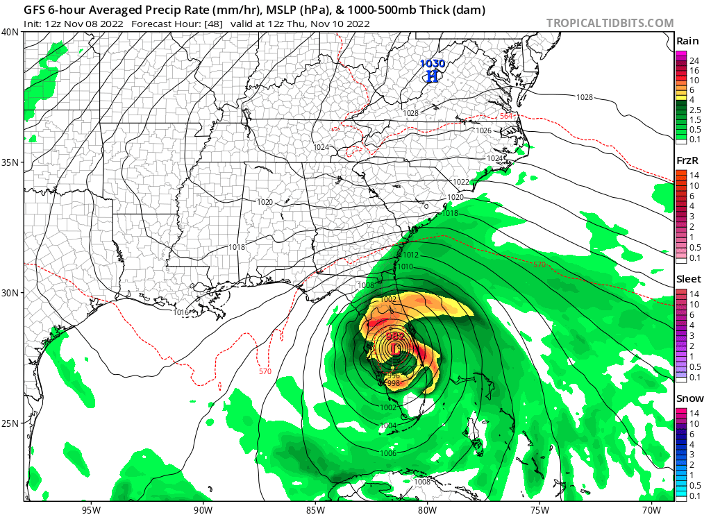
Landfall of TS Nicole is likely by late Wednesday night or early Thursday in east-central Florida and it can reach hurricane status beforehand. Map courtesy NOAA, tropicaltidbits.com
Tropical Storm Nicole to impact Florida and much of the east coast
“Nicole” remains a tropical storm at mid-day Tuesday over the southwestern Atlantic Ocean with sustained winds of 50 mph and is moving to the west at 9 mph. This turn to the west should continue during the next 24-36 hours with high pressure ridging positioned over the Southeast US. As such, Nicole will close in on east-central Florida by late tomorrow night or early Thursday morning. As Nicole travels over relatively warm waters of 27-28 degrees (C), some intensification can take place and an attainment of category 1 hurricane status is probable and there is even an outside chance of Nicole reaching category 2 status before landfall.
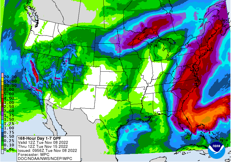
A major rain event of as much as 3-5 inches is in the offing from Florida-to-Maine as the tropical moisture field of Nicole will ride north to northeast along the eastern seaboard. Map courtesy NOAA/WPC
Weakening is expected after Nicole moves inland over Florida and the system will become influenced by a deep upper-level trough over the central states. This approaching large-scale upper-level trough will cause a dramatic shift in Nicole’s direction to the north and northeast; ultimately, resulting in a major rain event from Florida-to-Maine with as much 3 to 5 inches possible in some spots.
The center of Nicole is liable to ride up along the Appalachian Mountains on Friday and Friday night putting the coastal plain from the Carolinas to the Northeast US on the right side of the storm track. In this particular region, severe weather including tornadoes can become a serious threat with northeastward moving tropical systems…something to monitor on Friday and Friday night along coastal sections and the I-95 corridor.
A significant change to the overall temperature pattern in the eastern US will come in the wake of the tropical storm. Cold air masses that have been bottled up across western Canada and the western US will be able to reach into the eastern states as upper-level winds will change from recent days. Map courtesy NOAA, tropicaltidbits.com
Temperature pattern to change to much colder for the eastern US
The overall weather pattern has been very warm across the eastern states in recent days with spells of cold weather in the western US. In fact, temperatures on Monday climbed well up into the 70’s in many parts of the Mid-Atlantic and Northeast US…very likely the warmest day until next spring. The passage of a cold front ushered in noticeably cooler air for today and Wednesday, but an even more significant change to the temperature pattern will take place this weekend.
After Nicole exits out to the open waters of the western Atlantic early this weekend, the wind flow aloft will change to allow for the intrusion of cold air masses into the eastern states. These air masses have been bottled up in the western US and Canada in recent weeks, but will now be able to penetrate much farther to the south and east. Temperatures on Saturday night are likely to drop to near freezing in the Mid-Atlantic’s I-95 corridor and then a widespread hard freeze is possible late Sunday night with temperatures likely dropping well below the freezing mark. Looking ahead, there may be the threat of snow next week in parts of the eastern US as a couple of opportunities exist for moisture to push northward from the southern US and into the cold air mass that will become entrenched across the northeastern states.
Get ready…as discussed in the 2022-2023 Winter Outlook, winter this year may get off to a quick start.
Meteorologist Paul Dorian
Arcfield
arcfieldweather.com
Follow us on Facebook, Twitter, YouTube
Video discussion:


