11:30 AM | ***December is underway and the weather could get very interesting…signs point to a colder-than-normal pattern across much of the nation...may also become quite active in ten days or so***
Paul Dorian
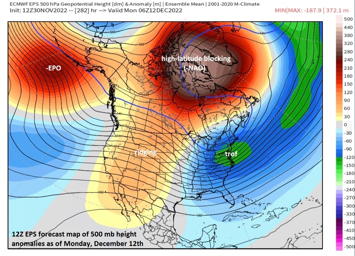
Yesterday’s 12Z run of the Euro ensemble features an upper-level pattern on December 12th that includes an upper-level trough of low pressure over the eastern US, very strong high-latitude blocking over Greenland and the Hudson Bay region of Canada, ridging of high pressure over the western US and strong ridging near the Aleutian Islands…all in all, a cold and potentially stormy pattern for the eastern states in about ten days or so. Map courtesy ECMWF, weathermodels.com
Overview
A strong cold front passed through the eastern states late Wednesday and much colder air has pushed in on stiff NW winds. This cold shot will be somewhat short-lived, however, as the first half of the upcoming weekend will turn much milder once again in the eastern US as the next frontal system approaches with a broad southwesterly flow of air ahead of it. Looking ahead, high-latitude blocking will develop in coming days and this will aid in a more sustained cold weather pattern in much of the nation with impact in the eastern states coming after about the 7th or so. In addition, the upcoming colder-than-normal weather pattern is likely to become more active before we get to the middle of the month and the period between about the 10th and 13th may be quite volatile near the eastern seaboard.
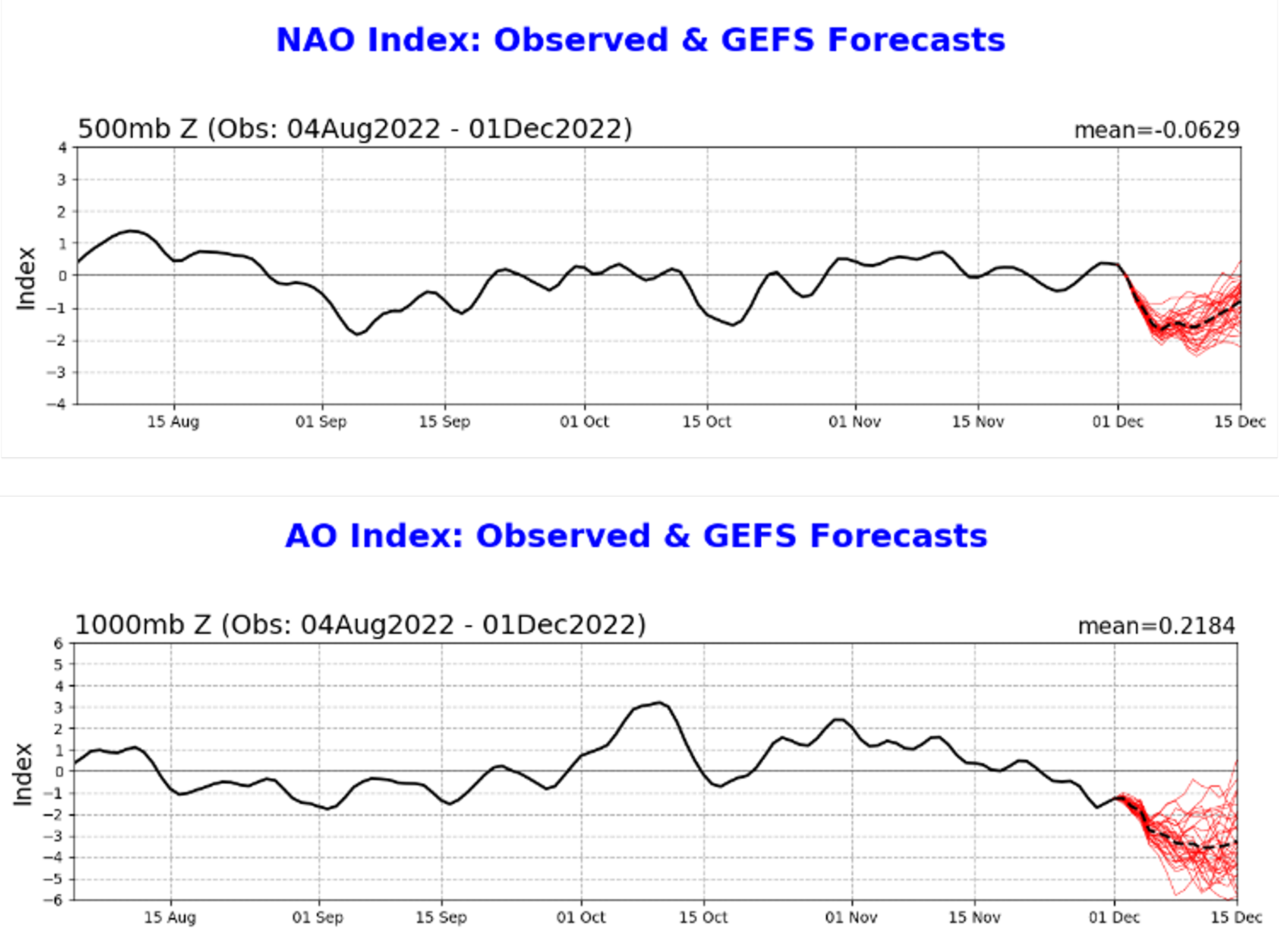
Teleconnection indices known as the NAO (top plot) and AO (bottom plot) are headed towards deep “negative” territory in coming days…a “red flag” for high-latitude blocking to form near Greenland and northeastern Canada. Plots courtesy NOAA
Teleconnection indices (NAO, AO, PNA) signaling cold and high-latitude blocking
Trends in teleconnection indices are closely watched this time of year as they can provide clues regarding upcoming weather conditions in the central and eastern US. Two such indices that we closely monitor here at arcfieldweather.com include the North Atlantic Oscillation (NAO) and its closely related cousin known as the Arctic Oscillation (AO). These indices give us a clue as to the pressure and temperature pattern over the North Atlantic and the Arctic regions of North America and they are both headed into relatively deep “negative” territory as we progress through the first half of December.
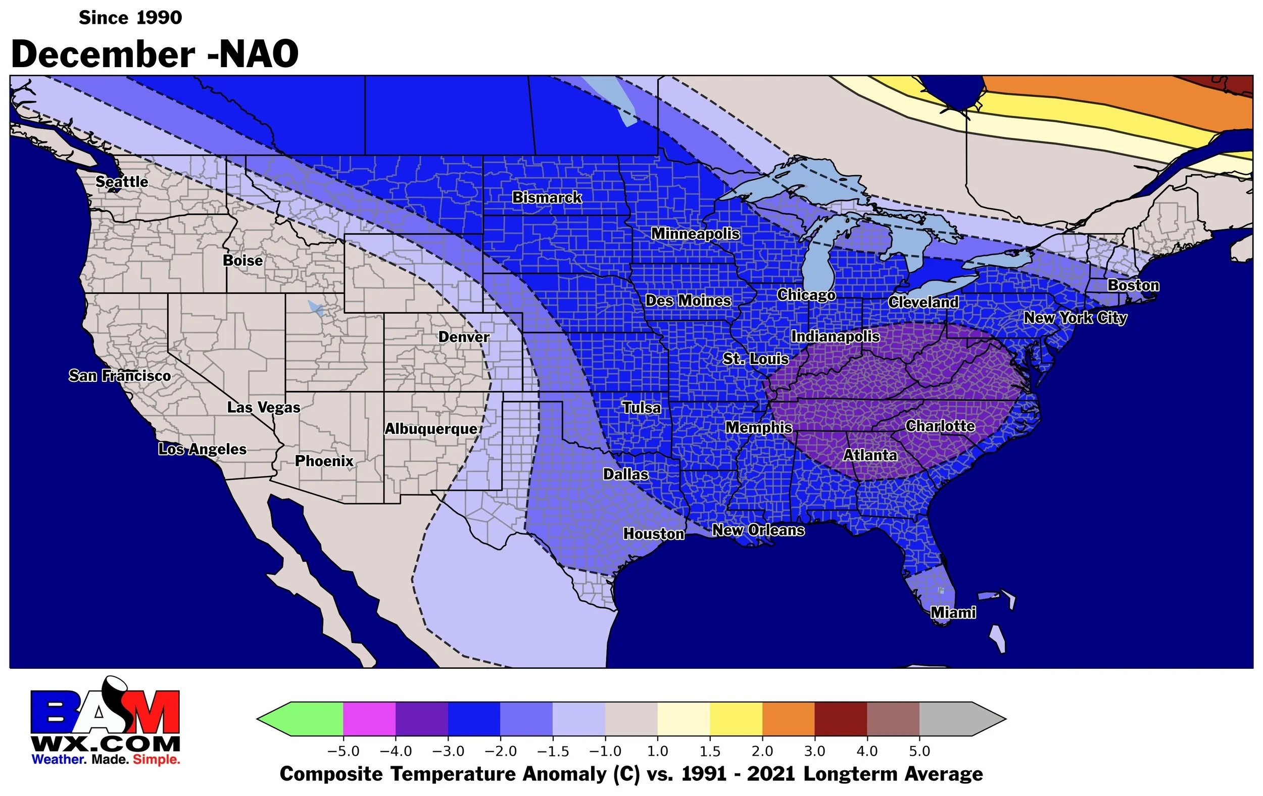
A “negative” NAO during the month of December has resulted in quite a bit colder-than-normal weather for the eastern two-thirds of the nation (data since 1990). Map courtesy BAMWX (Twitter)
One of the common outcomes in the North American weather pattern with the NAO and AO in “negative” territory for sustained periods of time is a phenomenon known as “high-latitude blocking”. Indeed, the “high-latitude blocking” that forms over the next several days may be the most extreme in many years the month of December. High-latitude blocking was highlighted in our Winter Outlook as a potential frequent occurrence this winter leading to our expectation of an overall colder-than-normal season. This kind of upper-level pattern generally features strong high pressure ridging over places like Greenland and northeastern Canada which, in turn, helps to enable cold air influxes into the central and eastern US from central Canada.
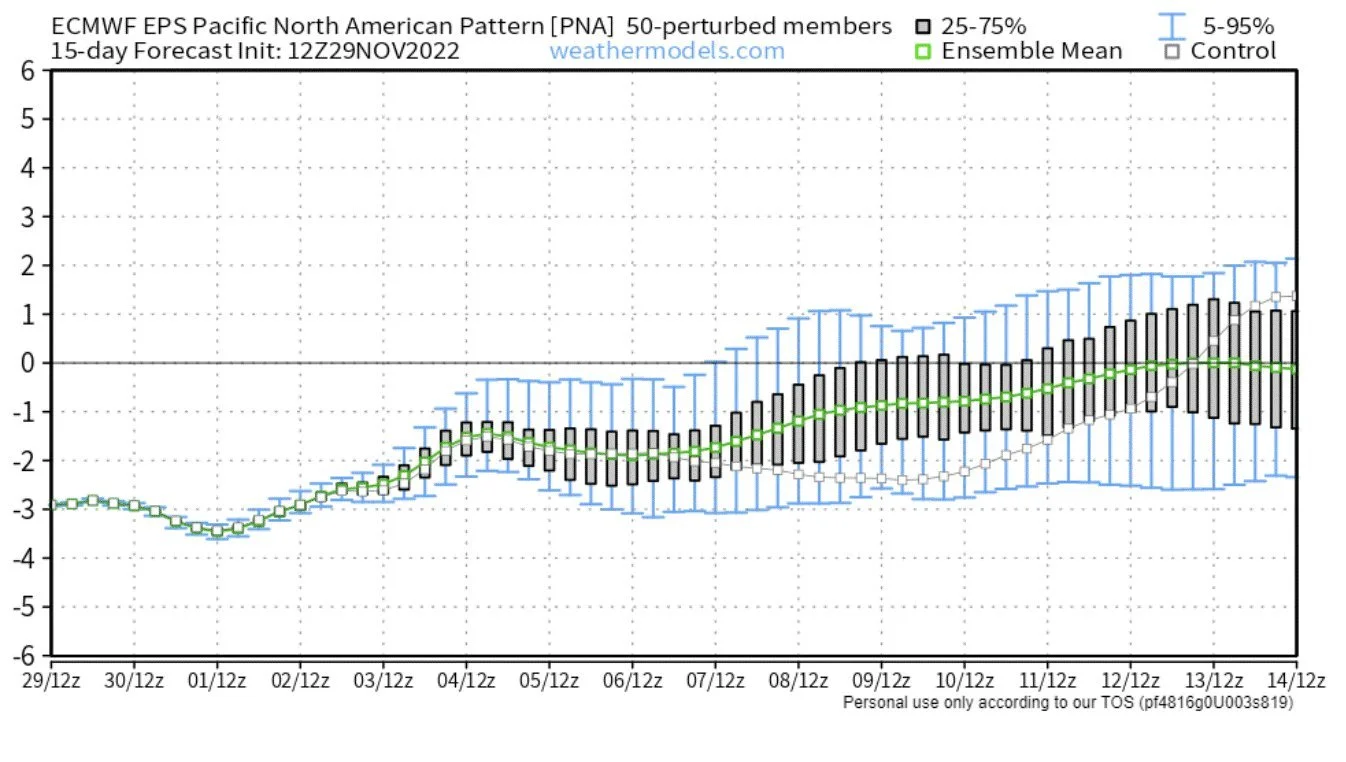
Yet another teleconnection index of interest is known as the Pacific North American (PNA) and it trends upwards in coming days to near neutral by mid-month. A neutral or positive PNA index value this time of year generally correlates with ridging of high pressure over western US and Canada which, in turn, aids in the influx of cold Canadian air masses into the central and eastern US and the formation/intensification of an eastern US upper-level trough of low pressure. Map courtesy ECMWF, weathermodels.com
Another teleconnection index known as the Pacific North American or PNA is important this time of year and it describes the differences of the 500 mb pressure level between the polar and equatorial zones of the Pacific Ocean and North America. This pressure difference has an important impact on the temperature and precipitation pattern over North America during the winter season.
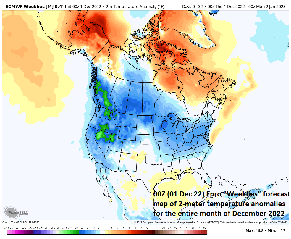
00Z Euro Weeklies 2-meter temperature anomaly forecast map for the entire month of December is suggesting colder-than-normal conditions across much of the nation and this is a notion that I support given the signals from the teleconnection indices cited in this blog. Map courtesy ECMWF, Weather Bell Analytics
A positive PNA is generally associated with ridging across the western US and Canada which can impact the weather in the eastern US in two ways. First, ridging in the western US and Canada will tend to aid in the formation and intensification of an upper-level trough of low pressure in the eastern states. Second, high pressure ridging across western US and Canada will help in the overall wind flow to transport cold Canadian air masses into the central and eastern US. The trend for this index is up as we progress through the first half of the month from its current “negative” value to near neutral by mid-month. In other words, the predicted trend of the PNA combined with the expected strong high-latitude blocking is looking more and more favorable for colder-than-normal weather across much of the nation and a stormier weather pattern in the eastern US by the middle of the month.
Stay tuned…December could get very interesting.
Meteorologist Paul Dorian
Arcfield
arcfieldweather.com
Follow us on Facebook, Twitter, YouTube
Video discussion:
