
2:00 PM | ****Arctic air mass drops south to Texas…Arctic front reaches I-95 corridor mid-day/afternoon on Friday...plunging temperatures, damaging winds, quick freeze, even a burst of snow****
Paul Dorian

Blizzard conditions will develop on Friday over the Great Lakes, Appalachian Mountains, and into the Northeast US as the Arctic blast arrives. In fact, very harsh weather conditions over the Great Lakes region will persist from Friday through much of the weekend. Map courtesy NOAA, tropicaltidbits.com
Overview
The core of an intensely cold Arctic air mass is now penetrating the northwest and north-central parts of the nation, and it will drop southward towards Texas during the next 48 hours. After that, the Arctic air mass will shift to the east and reach the eastern seaboard by late Friday. Numerous low temperature records are likely to be set over the next few days; especially, in the central US from the Canadian border to the Mexican border. Blizzard conditions will accompany this advancing Arctic air outbreak during the next few days over many sections of the country with the Great Lakes region likely to experience some of the worst with an extended period of extreme conditions from Friday into much of the upcoming weekend.
The strong Arctic frontal system that represents the leading edge of this intensely cold air mass will likely reach the DC-to-Philly-to-NYC corridor during the mid-day and afternoon hours on Friday. The passage of the powerful Arctic front will not go unnoticed. On the table will be plunging temperatures on the order of 25 or 30 degrees in a short period of time, powerful and potentially damaging wind gusts, a possible “flash-freeze”, and even a burst of snow that can put down a quick small accumulation of a coating to an inch or two. A frigid weekend will follow with Christmas Eve (Saturday) and Christmas Day (Sunday) the coldest in many years in much of the eastern half of the nation. Single digits are certainly a possibility along the I-95 corridor both on Saturday and Sunday mornings.
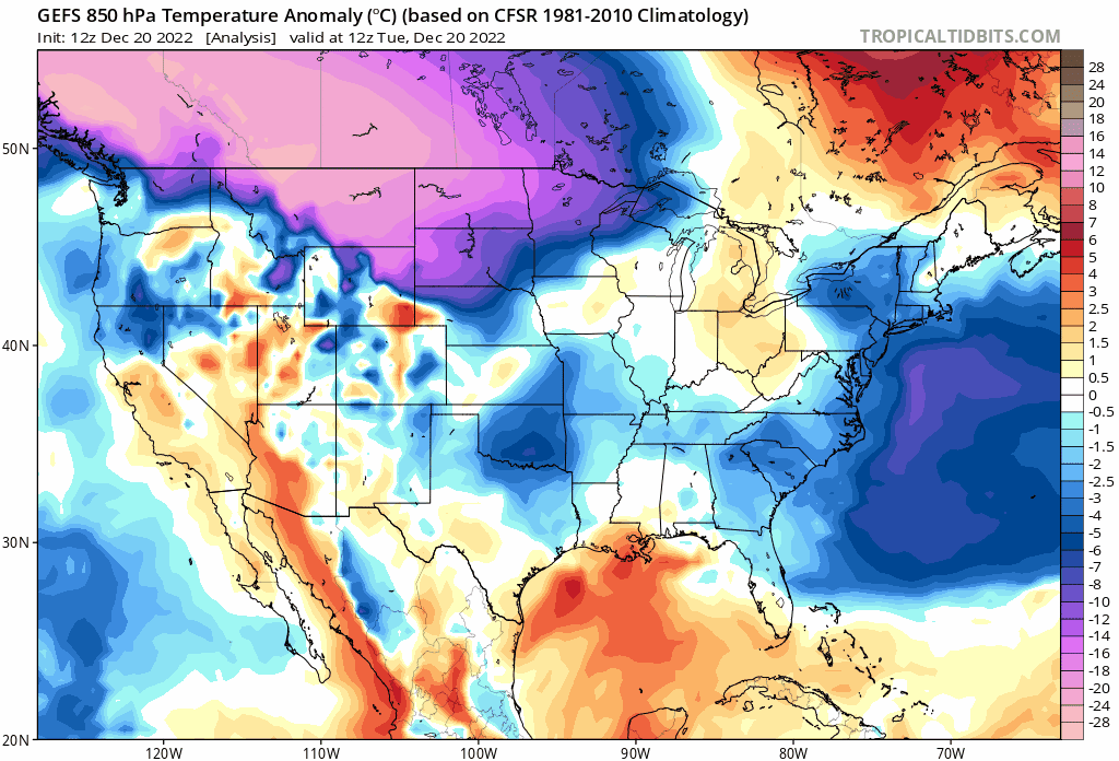
The Arctic blast that arrives in the northern US on Monday will drop southward to Texas over the next 48 hours and then shift to the eastern states on Friday. The upcoming weekend will feature some of the coldest conditions for Christmas Eve and Christmas Day in many years across the eastern half of the nation. Maps courtesy NOAA, tropicaltidbits.com (maps of 850 mb temperature anomalies extend from today to Monday, December 26th)
Major and widespread Arctic air outbreak
A major and widespread Arctic air outbreak has reached the northern US from the Pacific Northwest to the Northern Plains and the core of this cold air mass will drop southward to Texas by later Thursday. This intensely cold outbreak will likely result in numerous low temperature records over the next few days all the way from the Canadian border to the Mexican border. This frigid cold air mass had its origins on the other side of the North Pole over Siberia and “cross-polar” flow has allowed it to be transported from there to northwestern Canada and now into the northern US.
Mid-Atlantic soaking rain event from early Thursday into early Friday
On Thursday, strong low pressure will develop in the eastern US and it will push much milder air into the Mid-Atlantic and Northeast US on increasingly strong S-SE winds. There is a chance that enough cold air will be lingering around early on Thursday to result in a brief period of snow and/or ice in some of the northern and western suburbs along the I-95 corridor; however, temperatures should climb to well above freezing levels by later in the day. The rain can indeed fall heavily at times from later Thursday into Friday morning and a thunderstorm or two cannot be ruled out. This surge of mild air will likely peak on Friday morning with the 50’s likely in the I-95 corridor, but that warmth will disappear abruptly later in the afternoon on Friday.

Temperatures will plunge on Friday in the I-95 corridor after the passage of the powerful surface Arctic cold front. In fact, they can drop as much as 25 or 30 degrees in just a couple of hours which can lead to a “flash-freeze” whereby any wet spots on roadways from prior rainfall can quick ice up. maps courtesy NOAA, tropicaltidbits.com (maps of 2-meter air temperatures extend from Friday morning to Monday morning)
Powerful Arctic frontal passage on Friday mid-day/afternoon
By mid-day or early afternoon on Friday, the leading edge of this intensely cold Arctic air mass will reach the Mid-Atlantic’s I-95 corridor. The powerful Arctic surface front will have quite a dramatic passage at mid-day or early afternoon on Friday afternoon with strong and potentially damaging winds shifting to a W-NW direction, plunging temperatures as much as 25 or 30 degrees in just a couple of hours and this can cause a quick freeze-up or “flash freeze” of any lingering wet spots on roadways from the prior rainfall. In addition, there can be a burst of snow in the immediate aftermath of the frontal passage potentially producing a quick small accumulation of a coating to an inch or two.
Temperatures will continue to drop sharply on Friday night and the weekend promises to be frigid not only in the Mid-Atlantic region, but throughout the eastern half of the nation. In fact, this will likely turn out to be the coldest Christmas Eve (Saturday) and Christmas Day (Sunday) in many years in the eastern half of the country. Single digit temperatures are certainly on the table in the DC-to-Philly-to-NYC corridor both on Saturday morning and again on Sunday (Christmas) morning. Winds will remain quite strong all weekend long making it quite difficult for the lighting of luminaries in those neighborhoods that follow that tradition. In terms of a follow-up thaw in the eastern US, it is pretty much inevitable that temperatures will become noticeably milder later next week as this incoming Arctic air mass in the central and eastern US will actually be the coldest air in all of North America. The thaw can then continue into the first week of January as well in much the same part of the nation that will experience this intensely cold Arctic air outbreak.
Meteorologist Paul Dorian
Arcfield
arcfieldweather.com
Follow us on Facebook, Twitter, YouTube
Video discussion: