9:30 AM | ***Unusual cold today in the Mid-Atlantic with continuing strong winds...numerous snow showers/squalls will form in destabilizing atmosphere…cold air outbreaks to continue into mid-April***
Paul Dorian

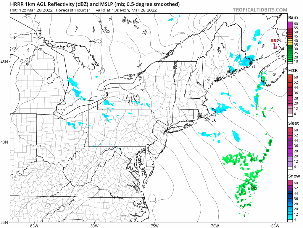
A high-resolution forecast model known as the HRRR captures well the likely development of numerous snow showers today in the Mid-Atlantic region and Northeast US. As the atmosphere destabilizes with the combination of low-level daytime heating and very cold air aloft, these snow bands will form in a NW-to-SE orientation running parallel to the northwesterly wind flow. Maps courtesy NOAA, tropicaltidbits.com
Overview
This is quite impressive cold today in the Mid-Atlantic region with many spots likely to have a real struggle to reach the freezing mark for highs – very late in the season for that to occur. The combination of early morning “spring-strength” sunshine and very cold conditions aloft has quickly destabilized the atmosphere and numerous snow showers and heavier snow squalls will affect the Mid-Atlantic region during the mid-day and afternoon hours. Any snow shower or heavier snow squall can put down a quick accumulation and create dangerous driving conditions. Winds remain strong as well today from a northwesterly direction producing wind chills even lower than the unusually cold actual air temperatures. Unfortunately, it looks like the cold air outbreaks can continue into the middle part of April.

Numerous spots experienced record or near record lows this morning and a repeat performance is quite likely on Tuesday morning. Map courtesy “coolwx.com”, NOAA
Details
The calendar says spring, but winter-chill has descended on the Mid-Atlantic region with many spots experiencing near record lows this morning and temperatures well below the freezing mark. Some spots may not be able to reach the freezing mark for highs this afternoon which is a rare occurrence for this late in the winter/early spring season. While the day started off with mainly clear skies, cumulus clouds have been building during the past couple of hours as the atmosphere destabilizes. The combination of low-level warming by the increasingly strong early spring sun and the very cold air aloft has steepened lapse rates and the result of the instability has been the formation of snow bands across interior sections of the Mid-Atlantic region. These snow bands are oriented in a NW-to-SE fashion – parallel to the low-level wind flow – and many will make their way into the I-95 corridor for the mid-day and afternoon hours and they should even be able to extend to areas south of the PA/MD border (e.g., northern MD, northern VA, DC metro). Any snow shower or heavier snow squall can put down a quick accumulation and generate dangerous driving conditions. This snow shower activity will wind down early this evening and another very cold night is in store for the Mid-Atlantic with late night temperatures again dropping to well below-freezing levels.

Cold air outbreaks will likely continue into the middle of April for the northeastern part of the nation. This forecast loop shows below-normal temperatures dominating the scene for the next ten days. Maps courtesy NOAA, tropicaltidbits.com
The unusual chill will stick around into mid-week in the Mid-Atlantic region and then much warmer air to the south and west of here will make an advance in this direction. Initially, the warmer air will be forced to ride up and over the entrenched cold air mass and this “overrunning” process can result in a bit of rain, sleet and/or snow from late Tuesday night into early Wednesday. By Thursday, the warmer air will win out and temperatures are likely to surge to 70 degrees in the DC-to-Philly-to-NYC corridor following highs generally limited to the 40’s on Wednesday. This dramatic warm up on Thursday will come at a cost, however, as showers are likely and a strong thunderstorm or two can form along and just ahead of incoming strong cold front. That same front may cause another outbreak of severe weather later Wednesday into Wednesday night across much of the same area that was hit last week including the Deep South and the Tennessee Valley. The passage of this next cold front will result in a cooler air mass around here on Friday and for the bulk of the upcoming weekend following the one-day dramatic warm up that is expected on Thursday.
Meteorologist Paul Dorian
Arcfield
arcfieldweather.com
Follow us on Facebook, Twitter, YouTube
Video discussion: