11:30 AM | ****Severe weather outbreak in the Deep South, Tennessee/Ohio Valleys...damaging wind gusts and tornadoes a high risk…threat shifts east on Thursday...cold air outbreaks to continue****
Paul Dorian

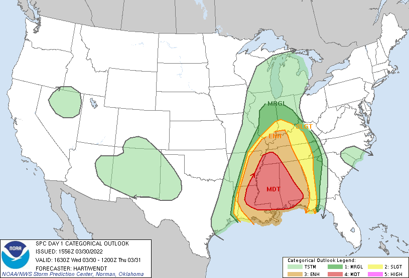
Much of the very same region that was hit hard last week by severe weather including tornadoes will be in the severe weather threat zone on Wednesday and Wednesday night with a focus on Louisiana, Mississippi and Alabama. Map courtesy NOAA/SPC
Overview
A severe weather outbreak on Wednesday and Wednesday night is coming to the same part of the nation that was hit hard last week including the Deep South, Tennessee and Ohio Valleys. One of the highest weather risks in this region will be for damaging wind gusts aided by strong jet streaks in multiple levels of the atmosphere. In addition, tornadoes may become rather numerous with many ingredients coming together in the atmosphere for rotation to form in many locations. The severe weather threat will shift to the eastern states on Thursday - albeit not quite as high - as a strong cold front pushes towards the coast and damaging wind gusts will again be on the table. Looking ahead, cold air outbreaks will likely continue for the central and eastern US into at least the middle of April and this will likely result in additional severe weather outbreaks.
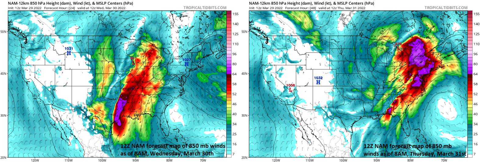
A strong low-level jet streak will increase the chances today (left) for damaging wind gusts across the Deep South, Tennessee and Ohio Valleys. This threat will shift to the eastern US on Thursday (right) as the strong low-level jet shifts to that part of the nation. Map courtesy NOAA, tropicaltidbits.com
Details
A colder-than-normal air mass is pushing east today from the Rocky Mountain States and it is one of several factors that will play a role in a severe weather outbreak across the Deep South (Louisiana, Mississippi, Alabama), Tennessee and Ohio Valleys. The clash of air masses with cold, dry (Canadian) air to the west of a strong surface cold front and increasingly humid and warm air to its east is setting the stage for severe weather. Looking ahead, many signs point to a continuation of cold air outbreaks into the US from Canada during at least the next couple of weeks and this will no doubt add to the chances for additional severe weather outbreaks as we push into the first half of April.

Strong winds in the upper part of the atmosphere will play a role in the severe weather threat today (left) across the Deep South, Tennessee and Ohio Valleys and in the eastern states on Thursday (right). Map courtesy NOAA, tropicaltidbits.com
In addition to the temperature contrast between cold, dry air to the west of the surface front and warm, humid air to the east, strong jet streaks at multiple levels of the atmosphere will play important roles in the severe weather expected today, tonight and on Thursday as well in the eastern states. Strong jet streaks in the lower and upper levels of the atmosphere will extend today from the south-central states to the Great Lakes and will help to strengthen upward motion; especially, across the Deep South, Tennessee and Ohio Valleys.
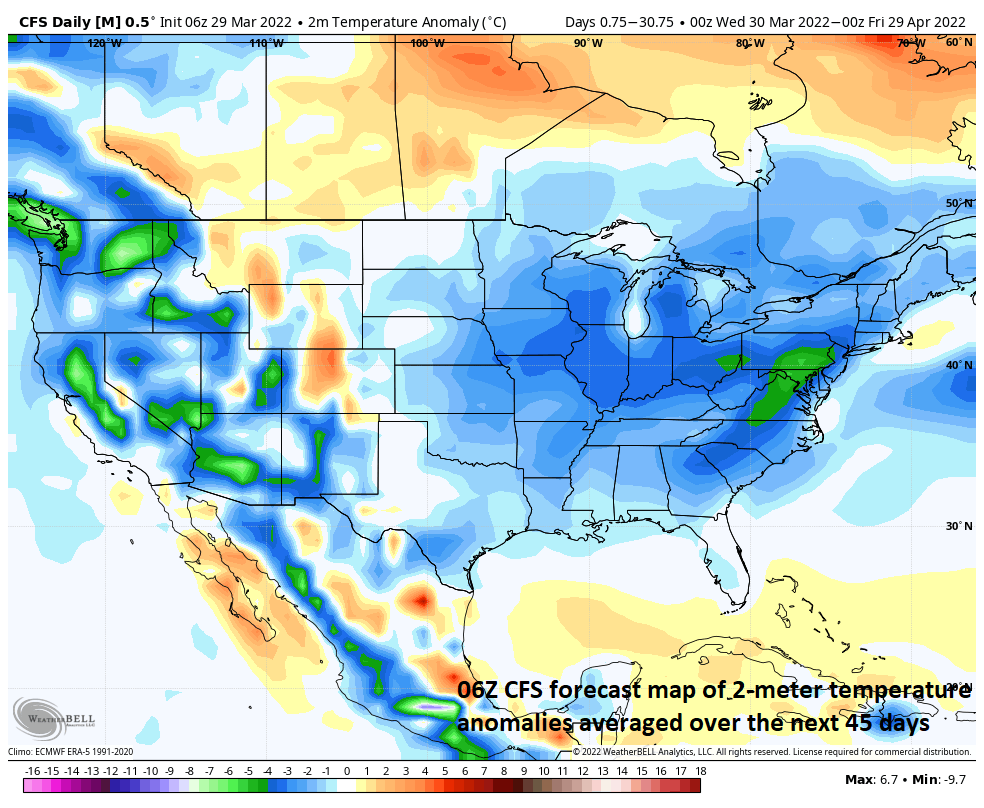
Cold air outbreaks will continue into the central and eastern states for the foreseeable future contributing to an on-going active weather pattern with additional severe weather outbreaks on the table. This forecast map depicts the 2-meter temperature anomalies across the US from now until the end of April and colder-than-normal conditions cover a large part of the nation. Map courtesy Weather Bell Analytics (Meteorologist Joe Bastardi, Twitter), NOAA
As the surface cold front slides into the eastern states on Thursday, the severe weather threat will also shift eastward albeit not quite as high as with today’s outbreak. Nonetheless, strong-to-severe thunderstorms will be possible later Thursday into Thursday night in the eastern US with damaging wind gusts on the table once again given the continuing strong winds at multiple levels of the atmosphere. The best chance of the severe weather will likely be in two region including the Southeast US and the Mid-Atlantic region in those areas along and to the west of Route I-95. Farther to the east in New Jersey and the Delmarva Peninsula, slightly cooler air is likely to limit atmospheric instability and have a suppressing effect on severe weather possibilities. Following the passage of the cold front, it’ll turn much cooler on Friday in the Mid-Atlantic/NE US and additional cold air outbreaks are looking quite likely going into at least the middle of April.
Meteorologist Paul Dorian
Arcfield
arcfieldweather.com
Follow us on Facebook, Twitter, YouTube
Video discussion: