
2:00 PM | **Tropical Storm Fiona to impact Caribbean islands this weekend…differing storm tracks thereafter are discussed with the most likely scenario in my opinion**
Paul Dorian

Latest satellite imagery reveals a low-level circulation center exposed to the west of the main convective cloud mass and this “decoupling” and asymmetric structure will limit intensification prospects of Tropical Storm Fiona in the near term. Images courtesy College of DuPage, NOAA
Overview
We have reached the mid-point of September and this is climatologically-speaking right around the peak time of the Atlantic Basin tropical season. True to form, there is a now a tropical storm named “Fiona” over the central Atlantic and it is likely to impact the Caribbean islands of Puerto Rico and Hispaniola later this weekend. Beyond that, it is somewhat unclear as to where Fiona will travel with one scenario featuring a continued movement to the west and towards the Gulf of Mexico and a second possibility with a “curvature to the north” over the Bahamas and then the western Atlantic off the eastern seaboard.

Multiple scenarios are on the table for the storm track of TS Fiona as depicted here for a variety of 00Z computer forecast model runs. Map courtesy Toomer Berg; ECWMF, UKMET, NOAA GFS
Discussion
As of 2PM on Thursday, Tropical Storm Fiona has sustained winds of 50 mph and is moving westward at 14 mph under the influence of a sub-tropical ridge of high pressure over the central Atlantic. The general westerly track should continue for the next few days which will bring Fiona across the northern Leeward Islands by tomorrow night and to near or over Puerto Rico later this weekend. By the end of the weekend or early part of next week, Fiona will likely be near or over the island of Hispaniola (Dominican Republic (east), Haiti (west)) and after this, considerable differences exist in some of the computer model forecast track scenarios.
In terms of intensification, there is currently an asymmetric structure of Tropical storm Fiona with the low-level circulation center decoupled from the main area of convection due to wind shear. [Stronger winds in the lower and middle levels of the atmosphere are combining with weaker winds aloft to create a vertical tilting of Fiona at this time]. In addition, mid-level dry air is in the vicinity of Fiona and this combination will limit its strengthening prospects in the near term as it heads towards the Caribbean. In addition, interaction with land masses in the Caribbean later this weekend could also put a damper on intensification prospects; especially, if there is movement directly over Hispaniola which has some high terrain that often disrupts the circulation pattern of a tropical cyclone. Despite the somewhat limited prospects of intensification for Tropical Storm Fiona, heavy rains are likely to spread into Puerto Rico and then Hispaniola later in the weekend with flash flooding/mudslides certainly on the table.
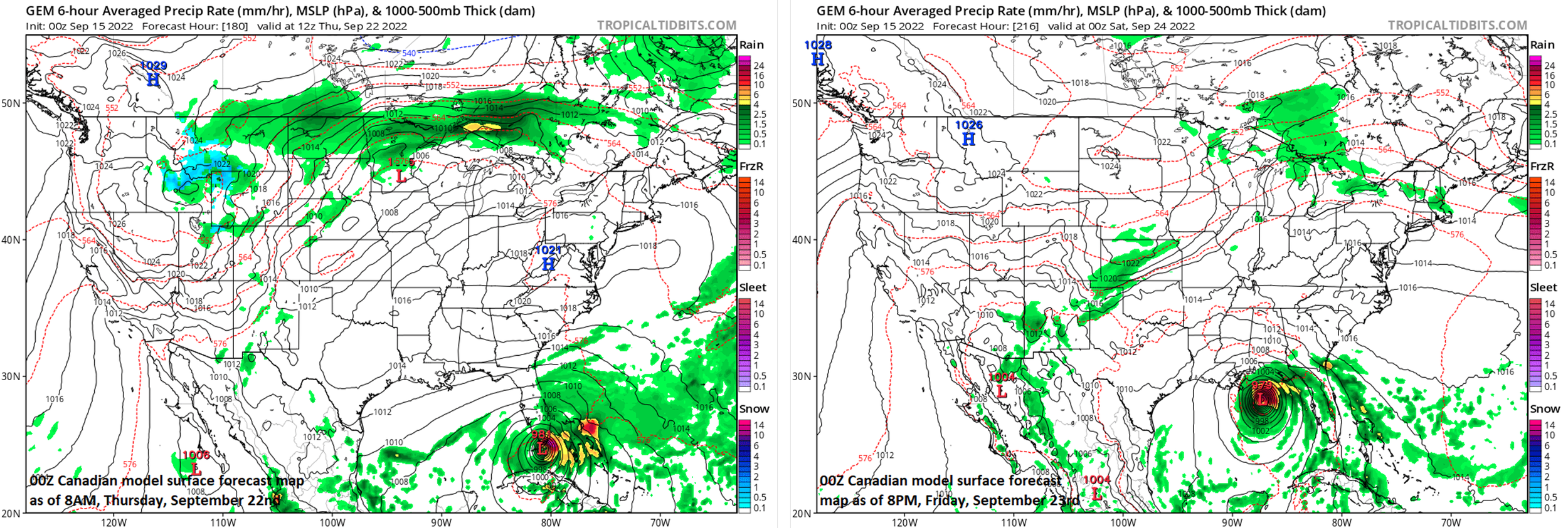
These surface forecast maps were produced by the 00Z Canadian model run and depict a continuation of the westward track of Tropical Storm Fiona that would bring the tropical system across Florida and into the Gulf of Mexico. Note: I believe this “westward” scenario as depicted here is much less likely to happen than the “curvature to the north” storm track as discussed in the blog. Maps courtesy Canadian Met Centre, tropicaltidbits.com
Looking ahead past the weekend, there are a couple different scenarios on the table for Tropical Storm Fiona. One scenario results in a continued general westward track of Fiona towards the Florida/Florida Straits and ultimately this could end up with the tropical system spilling out into the middle of the Gulf of Mexico. The 00Z Canadian model, for example, has this scenario as its favored solution. Other models including NOAA’s GFS tend to favor a second possibility that features a curvature of Fiona to the north by early next week - a scenario I do believe will play out - to a position first over the Bahamas and then to a location off the east coast out over the western Atlantic Ocean.

The 2022 Atlantic Basin tropical season has been below-normal so far as indicted in this table (upper right) by the “Accumulated Cyclone Energy (ACE)” which is a metric that is calculated by factoring in the magnitude and duration of tropical systems. With below-normal activity in the Pacific Ocean as well, the northern hemisphere as a whole has below-normal ACE also. Data courtesy Colorado State University, NOAA
One main cause of the significant differences in computer model storm tracks has to do with the magnitude and timing of the intensification of Tropical Storm Fiona. When a tropical system strengthens quickly and significantly at these latitudes, its storm track tends to become more and more influenced by the overall upper-air wind flow. In this case, NOAA’s GFS model more rapidly intensifies Tropical Storm Fiona than, for example, the Canadian model. Consequently, the GFS model develops a curvature to the north while the Canadian model keeps a weaker system on a much longer westerly track and takes Fiona all the way into the Gulf of Mexico either through the state of Florida or over the Florida Straits. As stated earlier, the “curvature to the north” scenario is what I believe will take place which would bring Fiona to near or over the Bahama Islands by early next week and then to a position over the western Atlantic Ocean by later next week. Beyond that, Fiona could meander for awhile over the western Atlantic which is always a worrisome thing. Hopefully, Fiona ultimately stays out-to-sea without ever directly impacting the US east coast, but that is way too far ahead to be certain.
Meteorologist Paul Dorian
Arcfield
arcfieldweather.com
Follow us on Facebook, Twitter, YouTube
Video discussion: