
****Ian returns to hurricane status as it heads towards landfall on Friday in South Carolina…remnants of Ian to bring heavy rain, gusty winds to the Mid-Atlantic later Friday and this weekend****
Paul Dorian
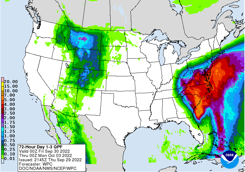
Heavy rain from the remains of Ian will slide up to the Mid-Atlantic region later Friday and the threat from rain will continue through the weekend. Torrential rain will fall across the Carolinas on Friday and Friday night as Ian makes a second landfall likely near Charleston around mid-day. Map courtesy NOAA/WPC
Overview
Ian has returned to hurricane status on Thursday evening over the warm waters of the Gulf Stream in the western Atlantic Ocean. It is likely to make another landfall as a hurricane…this time in South Carolina and likely near Charleston at mid-day. Rain from Ian’s remains will push northward into the Mid-Atlantic region late tomorrow and continue into the weekend and some of the rain will be heavy at times along with gusty winds.

Ian will make a second landfall on Friday in South Carolina and then likely meander over the Tennessee Valley this weekend extending the threat of rain in the Mid-Atlantic region until Sunday night or Monday. Map courtesy NOAA/NHC
Details
Ian made landfall on Wednesday in western Florida as a “major” hurricane and slowly crossed the state leaving behind tremendous flooding and more than 2 million residents without power. The storm weakened some on its trek across Florida, but emerged over the warm Gulf Stream waters of the western Atlantic and has returned to hurricane status. As such, Ian is likely to make a second landfall at mid-day Friday...this time near Charleston, South Carolina. Ian will then push towards the Tennessee Valley and heavy rain will push up along the eastern states reaching the Mid-Atlantic region late tomorrow and tomorrow night and continuing into Saturday.

A Euro model run on Thursday feature strongest wind gusts on Friday morning near the South Carolina coastline. Map courtesy ECMWF, Weather Bell Analytics
Given strong high pressure over the Northeast US, tight pressure gradient between the tropical system and high pressure will result in gusty winds across the Mid-Atlantic on Friday night and Saturday; especially, along coastal sections. The center of Ian will head to the Tennessee Valley and then to meander and this will extend the threat for rainfall in the Mid-Atlantic region into Sunday and Sunday night with up to 2 or 3 inches on the table for many spots.
Meteorologist Paul Dorian
Arcfield
arcfieldweather.com
Follow us on Facebook, Twitter, YouTube