
9:30 AM | **Potential exists for a severe weather outbreak on Friday night in the Mississippi Valley…powerful cold front reaches the eastern US on Saturday with possible damaging wind gusts**
Paul Dorian

Strong upper-level low will push into the middle of the nation by late Friday and it will become a key player in a possible severe weather outbreak across the Middle Mississippi Valley region. Map courtesy ECMWF, Pivotal Weather
Overview
Tornadoes are running at above-normal levels across the nation so far this season and there is the potential for another severe weather outbreak at the end of this week. In much the same manner as at the end of the last week, the atmosphere will become very unstable by Friday night in the Mississippi Valley region with a multitude of ingredients coming together including vigorous upper-level support, an intrusion of warm, humid air from the Gulf of Mexico, and an influx of cold, dry air from the north and west. A similar weather pattern late last week resulted in an outbreak of tornadoes across Mississippi and Alabama that tragically resulted in the death of at least 26 people. The powerful cold front that will play a major role in the late week severe weather threat in the Mississippi Valley will plow through the Ohio Valley and into the eastern states on Saturday possibly resulting in damaging wind gusts of 50-60 mph in those sections of the country.

Details
The number of tornadoes across the US so far this season is above-normal for this time of year and one of the culprits has been the continuation of cold air outbreaks from Canada into the US. This on-going influx of colder-than-normal air has resulted in the development of a “battle zone” region - across the Mississippi Valley in recent days - with warm and humid air entrenched across the southern states aided by persistent high pressure ridging aloft. With the cold, dry air charging to the south and east into the warm, humid air advancing to the north from the Gulf of Mexico, all it takes is for some vigorous support in the upper atmosphere to move overhead to dramatically raise the chances for severe weather. Indeed, this is the pattern that unfolded at the end of last week in the Lower Mississippi Valley/Deep South and, unfortunately, it can repeat at the end of this week likely this time in the central and northern Mississippi Valley regions with a focus area of concern in the states from Arkansas to Iowa.
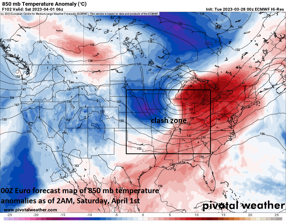
Warm, humid air will surge northward on Friday into the Mississippi Valley region ahead of an eastward-advancing strong surface cold front with abnormally cold and dry air on its back side. These two air masses will clash in the Middle Mississippi Valley region on Friday night potentially leading to some severe weather and tornadic activity. Map courtesy ECMWF, Pivotal Weather
The latest in a series of Pacific Ocean storms that will impact California over the next few days will become a crucial player in the potential severe weather outbreak at the end of the week in the Mississippi Valley. This system will produce coastal rains and inland snows across northern California from later today into tonight and will then slide slowly down the coast reaching southern California by Thursday with some shower activity. After that, the strong upper-level low associated with this newest ocean storm will push into the Rocky Mountain States and then head into the middle of the nation on Friday.
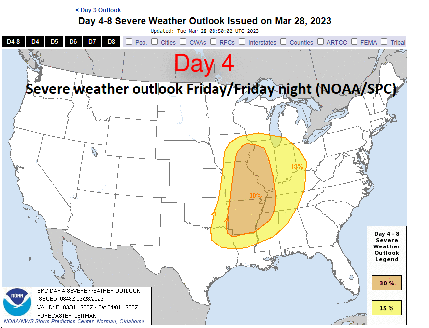
Still a few days away, but NOAA’s Storm Prediction Center (SPC) has already increased the severe weather probability across the Middle Mississippi Valley for later Friday/Friday night. Map courtesy NOAA
As such, upward motion will begin to strengthen later Friday across the Middle Mississippi Valley with warm, humid air flowing northward ahead of an incoming strong surface cold front advancing to the east. In addition, cold, dry air with its origins in Canada will be charging to the south and east across the central states. Once the upper-level support moves overhead on Friday night into this “clash” zone, severe weather can break out and isolated tornadoes are certainly on the table. The threat zone at this vantage point appears to be the central and northern Mississippi Valley regions which would be slightly to the north of outbreak that took place late last week. Farther to the north, accumulating snow is quite likely across portions of the Upper Midwest likely extending from Iowa-to-Wisconsin-to-Upper Michigan.

The powerful surface cold front that will contribute to possible severe weather on Friday night in the Middle Mississippi Valley will plow to the east late Friday night and Saturday. While the threat of severe weather may become somewhat diminished, there certainly is a chance for damaging wind gusts in the Ohio Valley and eastern US late Friday night and Saturday. Map courtesy ECMWF, Pivotal Weather
This powerful surface cold front will continue to plow to the east late Friday night and on Saturday…first across the Ohio Valley and through the Atlantic states. Severe weather cannot be ruled out from the Ohio Valley to the eastern states and there certainly is the threat for damaging wind gusts of 50-60 mph given the strong low-level winds expected in the vicinity of the surface cold front. Temperatures on Saturday ahead of the strong cold frontal system can climb to 70+ degrees in the DC-to-Philly-to-NYC corridor to go along with those very windy conditions. However, on the back side of the front, temperatures are likely to be some 15-20 degrees colder on Sunday with highs much closer to the 50 degree mark and there will be a stiff NW wind as well.
Meteorologist Paul Dorian
Arcfield
arcfieldweather.com
Follow us on Facebook, Twitter, YouTube
Video discussion: