1:20 PM | ***Active weather in the ”ring of fire”…TS Franklin may reach "major" hurricane status…”Harold’s” moisture hits the Four Corner states…intense heat wave with very high humidity levels***
Paul Dorian

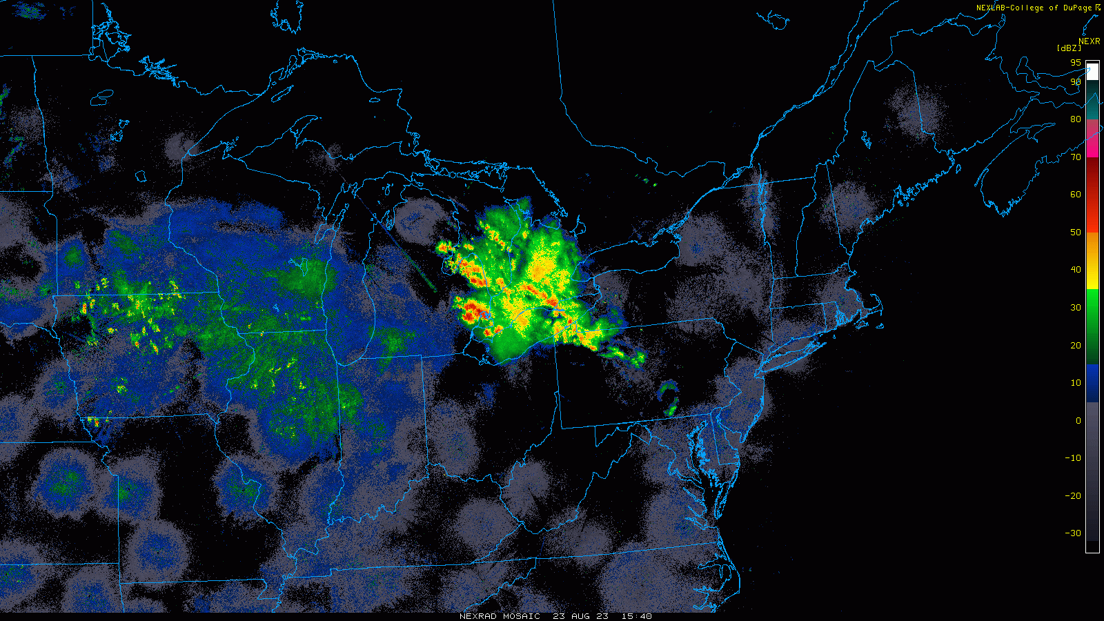
This radar loop features a batch of heavy showers and embedded thunderstorms that has developed in the “ring of fire” region on the outer perimeter of the central US high pressure ridge. The region across the Ohio Valley/Great Lakes, Mid-Atlantic and NE US will remain quite active right into the upcoming weekend. Images courtesy NOAA, College of DuPage
Overview
A lot is going on in the world of weather highlighted by multiple tropical systems, an intense heat wave with very high humidity levels anchored by very strong upper-level high pressure ridging, and very active weather in the “ring of fire” around the outer perimeter of that same high pressure system. On the tropical scene, Tropical Storm Franklin is pounding away today at Haiti and the Dominican Republic and once it bypasses this high-terrain Caribbean island of Hispaniola into the open waters of the Southwest Atlantic, it will intensify into a hurricane with a decent chance of attaining “major” categorization of 3 or higher. Meanwhile, the moisture associated with the remnants of Tropical Storm Harold which pounded southern Texas earlier this week will douse the Four Corner states during the next couple of days. Finally, there is the chance that a tropical systems forms this weekend in Caribbean Sea and it could move north next week and impact portions of the Southeast US.
Elsewhere, very strong ridging of high pressure over the nation’s midsection is anchoring an intense heat wave from the Upper Midwest to the Gulf coast. This heat wave is made worse by very high humidity levels that have featured dew points as high as 80 degrees in some spots. On the outer perimeter of this very strong high pressure ridge is a region that I like to refer to as the “ring of fire”, there is some very active weather that is bringing heavy showers and strong thunderstorms to the eastern Great Lakes. This “ring of fire” activity will spread to the south and east bringing heavy showers and strong thunderstorms to the Mid-Atlantic/Northeast US during the next couple of days.

Very strong upper-level ridging of high pressure is centered today over the nation’s mid-section and is the anchor for a widespread heat wave. This system will slowly retrograde to the west during the next several days likely becoming re-positioned over the Four Corners region by the middle of next week. Map courtesy NOAA, tropicaltidbits.com
Tropical Storm Franklin and a potential Caribbean Sea system
Tropical Storm Franklin is pounding away today with heavy rain and strong winds at the countries of Haiti and the Dominican Republic on the Caribbean island of Hispaniola. This tropical system currently has maximum sustained winds of 40 mph and is moving to the north at 13 mph. There is some high terrain on Hispaniola and this will inhibit chances of intensification in the near-term, but prospects are high for strengthening thereafter once TS Franklin bypasses the island, turns to the northeast, and heads out to the open waters of the southwest Atlantic Ocean. In fact, TS Franklin may reach minimal hurricane status by late Friday and then perhaps climb to “major” status later this weekend (category 3 or higher).

Tropical Storm Franklin is pounding away today at the Hispaniola countries of Haiti (western side), Dominican Republic (eastern side). Once Franklin bypasses the high-terrain island, it will likely strengthen into a minimal hurricane by late Friday and then perhaps to a “major” classification late this weekend. Map courtesy NOAA, College of DuPage
By the early part of next week, Franklin will likely pass Bermuda to its west and continue heading in a direction - seemingly towards the Mid-Atlantic or NE US coastline. However, reinforcing upper-level troughs of low pressure are likely to continue to drop into the northeastern states which would reduce significantly any chance for Franklin to ever reach all the way to the US east coast…however, this is still something to closely monitor in coming days.
One other note, there is the chance that another tropical system forms in the Caribbean Sea this weekend and it could move northward into Florida and potentially impact the rest of the Southeast US. In addition to the upper-level trough expected over the NE US, this potential tropical system in the SE US early-to-mid next week could actually be another factor in the inhibition of Franklin moving anywhere too close to the US east coast.

Remnant tropical moisture from Tropical Storm Harold will result in some decent rainfall across the Four Corner states of New Mexico, Arizona, Colorado and Utah. In addition, copious amounts of rain will fall in the “ring of fire” region across portions of the Great Lakes, Mid-Atlantic and NE US located on the outer perimeter of strong high pressure ridging that centered over the nation’s mid-section. Map courtesy NOAA, tropicaltidbits.com
Remnants of Tropical Storm Harold
Tropical Storm Harold formed in the western Gulf of Mexico earlier this week and then pushed westward across southern Texas producing heavy rainfall and strong winds in that part of the Lone Star State. It has since weakened considerably; however, there remains a large moisture field pushing from southeast-to-northwest that has already reached the state of New Mexico. This tropical moisture will continue to push in a northwesterly direction in the near-term and the result will be some decent rainfall across all the “Four Corner” states of Arizona, Utah, Colorado, and New Mexico. Over this past weekend, portions of the SW US including Arizona experienced some rainfall as a result of Tropical Storm Hilary which made landfall in Mexico (Baja peninsula) and then crossed the US/Mexico border into the southern part of California.

Temperatures are way above normal from the Upper Midwest to the Gulf of Mexico and the intense heat is made worse by very uncomfortably high levels of humidity. Ma courtesy NOAA, tropicaltidbits.com
Intense heat wave associated with very strong upper-level ridging
The heat has been intense and the humidity at very uncomfortable levels in recent days all the way from the Upper Midwest to the Gulf coast. In some spots, temperatures have climbed to 100 degrees for highs with dew points flirting with the 80 degree mark making for heat indices as high as 115 degrees. At the heart of this intense heat wave is a very strong upper-level ridge of high pressure that has been centered over the middle of the nation with the high heat and humidity underneath extending all the way from the Upper Midwest to the Gulf coast. Over the next few days, this upper-level ridge may actually retrograde slowly to the west - perhaps repositioning over the Four Corner region of the country by the middle of next week. This type of westward movement of the ridge will bring about relief in the intense heat from the Upper Midwest to the Gulf coast and would increase the heat across the interior western US.

The “ring of fire” region around the outer perimeter of very strong high pressure ridging will feature numerous heavy showers and strong thunderstorms during the next couple of days. These batches of showers and storms will impact the Great Lakes, Mid-Atlantic and Northeast US between today and the beginning of the upcoming weekend. Maps courtesy NOAA, tropicaltidbits.com
Active weather in the “ring of fire” across the Great Lakes/Mid-Atlantic/NE US
While the middle of the nation experiences high heat and humidity, the Mid-Atlantic region and Northeast US have enjoyed an overall comfortable weather pattern featuring pleasant temperatures and low humidity. The winds in the upper part of the atmosphere across the northeastern states have been consistently in a northwesterly direction during this favorable weather pattern resulting in comfortable temperatures and humidity. This persistent northwesterly flow of air is in a region on the outer perimeter of the strong high pressure ridge that I like to refer to as the “ring of fire” as it often becomes very active with heavy rain and strong thunderstorms – and that is indeed the case today and will be for the next couple of days.
A batch of heavy showers and embedded strong thunderstorms is currently impacting the eastern Great Lakes and northwestern sections of the Mid-Atlantic region. This activity will continue to drop to the south and east in coming hours and the rest of the Mid-Atlantic region and parts of the Northeast US can experience off and on showers and thunderstorms from later tonight into the upcoming weekend. While there will be much rain-free time in this period, any rain that falls from later tonight into the weekend can be heavy at times across the Great Lakes/Mid-Atlantic/Northeast US.
Meteorologist Paul Dorian
Arcfield
arcfieldweather.com
Follow us on Facebook, Twitter, YouTube
Video discussion: