1:30 PM | **”Long-tracking” tropical system to be closely monitored next several days…to become a “major” hurricane (named Lee) and heads towards the US east coast**
Paul Dorian

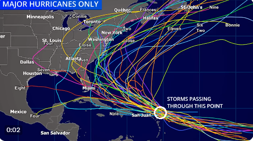
A historical view of “major” hurricanes that pass through the location just to the northeast of the Lesser Antilles suggests the door will be opened for an ultimate impact on the Bahamas and perhaps the US east coast.
Overview
A tropical wave that pushed off of Africa’s west coast several days ago has officially become tropical depression #13 in the Atlantic Ocean. This system is likely to reach named tropical storm status within 24 hours or so (will be named Lee) and very well could intensify to “major” hurricane status by the upcoming weekend. The overall environment will become increasingly conducive for intensification of the soon-to-be named tropical system in coming days as it continues on a long track across the Atlantic Ocean. Wind shear will relax as an upper-level ridge builds nearby and it’ll move over very warm waters to the east of the Lesser Antilles. Looking ahead, it appears this system may push to the northeast of the Lesser Antilles - avoiding the Caribbean Sea - and then head on a course towards the US east coast as a “major” hurricane. Whether or not this developing tropical storm ever reaches the US east coast is simply too early to call.
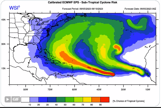
This forecast map of upcoming “tropical cyclone risk” comes from the ensemble run of the 00Z Euro. Map courtesy ECMWF
Details
Tropical Depression #13 features maximum sustained winds of 35 mph at mid-day and is pushing west-to-northwest at around 15 mph. This tropical wave pushed off of Africa’s west coast several days ago and is a “long-tracking” type of storm that will travel over the main development region of the tropical Atlantic Ocean for many days to come. All signals point to significant intensification of this system likely to reach named tropical storm status within 24 hours or so…will be named Lee.

NOAA’s hurricane forecast model called the “HWRF” predicts a powerful hurricane to be be positioned just to the northeast of the Lesser Antilles by later this weekend. Map courtesy NOAA, tropicaltidbits.com
Later this week, environmental conditions will become even more favorable for strengthening and Lee is very likely to climb to “major” hurricane classification by the weekend and “category 5” is on the table. To begin with, wind shear will relax compared to current levels as high pressure ridging forms nearby over the central Atlantic Ocean. In addition, this system will begin to move over some very warm waters (near 30 degrees (C) of the tropical Atlantic as it approaches the Lesser Antilles. Looking ahead, it appears the overall wind field will allow soon-to-be named Lee to bypass the Caribbean Sea and move to a position just to the northeast of the Lesser Antilles. Judging by past “major” hurricane tracks through this specific location, a path like this just to the northeast of the Lesser Antilles would open the door for a potential impact on the Bahama Islands and perhaps ultimately on US east coast.

Two big players in the ultimate storm track of soon-to-be named Lee will be an upper-level trough over the Ohio Valley/eastern US early-to-mid next week and an upper-level ridge over the Canadian Maritime Provinces. Map courtesy Canadian Met Centre, tropicaltidbits.com
A couple of key players to monitor in coming days will be an upper-level trough that may develop over the Ohio Valley/eastern US in about a week’s time at the same time upper-level ridging forms over Canada’s Maritime Provinces. The interaction between these two possible upper-level systems and the potential “major” hurricane will help determine its ultimate track. Current model forecast projections do consistently favor a curving of this developing tropical system before it ever reaches the US east coast. However, while this is quite hopeful, it is just too far out in advance, in my opinion, to be highly confident of a curvature away from the US east coast. Two such recent examples of hurricanes that were projected to curve away from the US east coast at this vantage point - and ultimately did not - include Florence in 2018 which ended up pounding away at the Carolinas with tremendous amounts of rainfall and Irma in 2017 which eventually significantly impacted places as far to the south and west as Key West, Florida.

In addition to the expected relaxation of wind shear, a contributing factor for intensification of soon-to-be named Lee will be very warm waters in the tropical Atlantic that it’ll move over in coming days. Map courtesy NOAA, tropicaltidbits.com
For now, all interests along the US east and Gulf coasts (and in the Bahamas) should keep a close eye on the soon-to-be named tropical storm Lee as it continues on a “long track” across the tropical Atlantic Ocean. One final note, there is a trailing tropical wave that has just exited the west coast of Africa and it is quite likely to also reach named tropical storm status in coming days (would be named Margot).
Meteorologist Paul Dorian
Arcfield
arcfieldweather.com
Follow us on Facebook, Twitter, YouTube
Video discussion: