1:15 PM | ***One of the coldest starts to December in many years...significant mountain snows western US...interior, higher elevation snows NE US later this week...Great Lake snow event(s)***
Paul Dorian
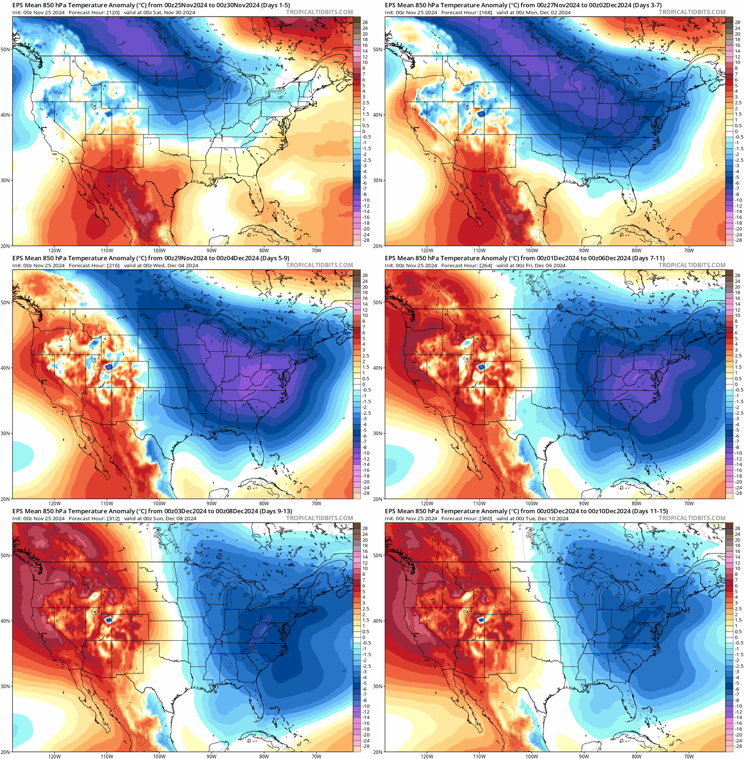
A cold pattern is unfolding for much of the nation beginning at the end of this week and likely lasting into at least the second week of December. In fact, this could be one of the coldest starts to December across much of the nation in many years with the colder-than- normal conditions extending all the way south and east to the Gulf coast. Maps courtesy NOAA, tropicaltidbits.com
Overview
Low pressure will push eastward across the higher elevations of the western US during the next few days resulting in significant snow accumulations on the order of 1-2 feet from the Sierra Nevada Mountains of easter California to the Colorado Rockies. This same low pressure system will then spill out into the middle of the nation at mid-week and move rather quickly across the Tennessee Valley on Wednesday night and to the Mid-Atlantic coastline by mid-day Thursday. As a result, rain is likely to reach the DC-to-Philly-to-NYC corridor by late Wednesday night and continue into Thursday (Thanksgiving Day) morning. Farther to the north, accumulating snow may fall from Thursday into Friday across interior, higher elevation locations of upstate PA and upstate NY to New England.
Following the departure of the low pressure system to the western Atlantic, a northwesterly flow of air will develop across the northeastern states bringing much colder-than-normal air from Canada into the Great Lakes, Mid-Atlantic and NE US. The “Great Lakes snow machine” will turn on with the much colder-than-normal air flowing over the still relatively warm waters of the Great Lakes. Looking ahead, the influx of much colder-than-normal air into the eastern states by this weekend will begin a cold pattern that is likely to last well into December... one of the coldest starts in many years to the month of December and it will have a “Siberian connection”.
The next few days will feature as much as 1-2 feet of snow across mountains of the western states all the way from the Sierra Nevada of eastern California to the Colorado Rockies. Map courtesy NOAA, tropicaltdbits.com
Western US mountain snows
Low pressure is pushing into the western US today from the eastern Pacific Ocean and it has with it copious amounts of moisture. This system will slide eastward during the next 48 hours or so resulting in substantial snowfall on the order of 1-2 feet from tonight into Wednesday all the way from the Sierra Nevada Mountains of eastern California to the Colorado Rockies...all good news for skiers in that part of the nation.
The “Great Lakes snow machine” is about to get turned on with a classic setup unfolding by week’s end with very cold air pouring over the still relatively warm (and unfrozen) lake waters and resulting in some substantial snowfall amounts (circled regions). Map courtesy NOAA, tropicaltidbits.com
Rain along I-95 corridor later this week with interior, higher elevation snows
The low pressure system that will bring substantial snows to the western US mountains between today and Wednesday will spill out into the nation’s heartland at mid-week and then move rather quickly from the Tennessee Valley on Wednesday night to the Mid-Atlantic coastline by mid-day Thursday (Thanksgiving Day). Rain is likely to be the predominate precipitation type in the DC-to-Philly-to-NYC corridor from late Wednesday into Thursday morning which could be a damper on the annual Thanksgiving Day parade in New York City. Farther north, snow is likely to fall from upstate PA to upstate NY to interior New England between Thursday and early Friday and several inches could pile up in some of the higher elevation locations. By late Friday, the departing low pressure system will intensify over the western Atlantic and strong NW flow will develop on its backside.
The waters of the Great Lakes are still relatively warm at this time of year (generally in the 40’s and 50’s) and this will set the stage for “lake effect” snows from later Friday into Saturday and perhaps even right through the upcoming weekend. As a result, snowfall amounts can be significant by the latter part of the weekend in many spots just downstream of Lakes Erie, Huron, and Ontario. Map courtesy NOAA/ERL
Great Lakes snow event later Friday into Saturday (and beyond)
A major Great Lakes snow event is setting up for the end of the week and weekend with substantial snow accumulations on the table in many spots just downstream of Lakes Erie, Ontario, and Huron. This looks like the classic setup for significant “lake-effect” snow as very cold air will flow over the still relatively warm (and unfrozen) waters of the Great Lakes for an extended period of time. In fact, lake effect snows can begin later Friday and last all the way through the upcoming weekend and this snow event may not be the only one as this cold weather pattern likely lasts into at least the second week of December…bringing with it additional chances of “lake-effect” snow.
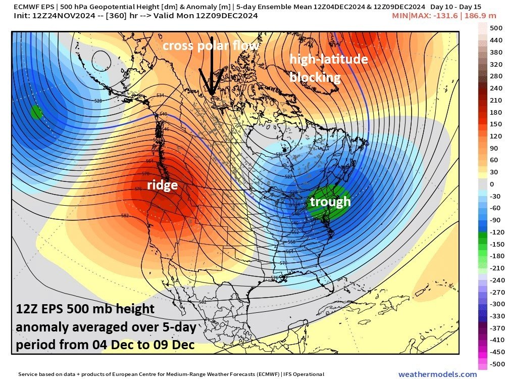
The combination of strong high pressure ridging along the US and Canadian west coasts, blocking high pressure over Greenland/NE Canada, and a deep upper-level trough centered over the northern Mid-Atlantic will allow for the transport of much colder-than-normal air from northwestern Canada into the northern US during the beginning stages of December. In fact, “cross polar” flow is possible in this upcoming weather pattern that would bring very cold Siberian air onto the North America side of the North Pole. Map courtesy ECMWF, weathermodels.com
One of the coldest starts to December in many years with a Siberian connection
An overall very wintry weather pattern is shaping up for much of the central and eastern US from late this week well into the month of December. In fact, this will turn out to be one of the coldest starts to December in many years. The upper air pattern will favor the transport of cold air masses from northwestern Canada into the northern US as we progress from later this week into at least the second week of December. In fact, there are signs for “cross polar” flow to develop which would allow for the transport of Siberian air from the Asian side of the North Pole to the North America continent.
These upcoming cold air intrusions from Canada into the US can make their way all the way down to the Gulf coast…this particular outbreak early next week is destined to push way below-normal air into central and southern Florida…hope you like your orange juice on the cold side. Map courtesy ECMWF, weathermodels.com, Dr. Ryan Maue, (X)
The upper-atmosphere pattern should feature strong ridging over Alaska (-EPO) which can transport Siberian air into North America and a strong ridge over the west coasts of Canada and the US (+PNA) can then help to move the cold air masses from northwestern Canada into the US, and, in some cases, all the way down to the Gulf coast. In addition, there will be continued high-latitude blocking high pressure over northeastern Canada and Greenland (west-based -NAO) and this will act to keep this cold weather pattern locked in place for some time…at least until the second week of December.
Meteorologist Paul Dorian
Arcfield
arcfieldweather.com
Follow us on Facebook, Twitter, YouTube
Video discussion:


