***An upcoming active pattern with several signals (MJO, SSW, PNA) pointing to additional Arctic air outbreaks for the central and eastern US***
Paul Dorian

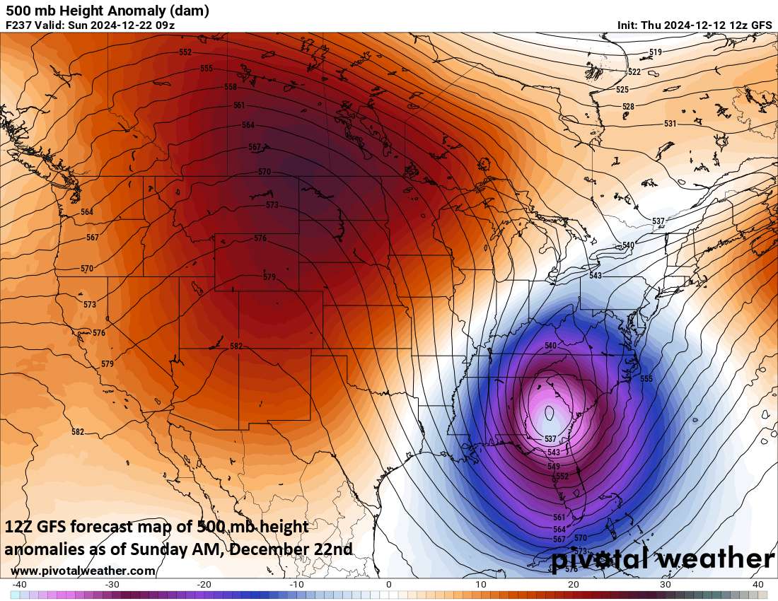
There are signs for a strong storm system to form somewhere near the east coast late next week and/or during the subsequent weekend. Of course, many details have to be ironed out, but this will be something to closely monitor next week. Map courtesy NOAA, Pivotal Weather
Overview
The month of December has started off with a few Arctic air outbreaks into the central and eastern US and while the overall pattern may turn somewhat milder for part of next week, there are multiple signals pointing to additional cold air outbreaks from later next week into the month of January. In addition, the unfolding weather pattern appears to be quite active with numerous storm systems to deal going through the second half of the month of December.
One of the signals for additional cold air outbreaks revolves around an oceanic-atmospheric phenomenon known as the Madden-Julian Oscillation or MJO. A second centers around a phenomenon that features warming over the polar region in the upper part of the atmosphere known as the stratosphere. Finally, a teleconnection index known as the Pacific-North American (PNA) is likely to feature a positive phase for much of the rest of the month and this generally favors high pressure ridging across the western US and Canada which, in turn, is usually favorable for cold air outbreaks to make their way from northern Canada into the central and eastern US.

Signals point to colder-than-normal weather for the central and eastern states later this month and this forecast map by the 00Z Euro features colder-than-normal conditions for the 5-day period of 20 December to 25 December. Map courtesy ECMWF, Weather Bell Analytics
An upcoming active weather pattern
There are signs for quite an active weather pattern during the next couple of weeks with the potential of multiple systems to deal with across the central and eastern US. In the near-term, after a relatively quiet and dry start to the weekend, a low pressure system is likely to produce some rain, ice and snow in the Mid-Atlantic region from later Sunday into Monday. The possibility of snow and/or ice later Sunday/Sunday night exists all the way into the northern and western suburbs along the DC-to-Philly-to-NYC corridor where a “cold air damming” scenario will make it quite difficult to dislodge low-level Arctic air at the onset of this late weekend system. A few inches of snow can fall late Sunday and Sunday night across upstate PA and upstate NY.
Another low pressure system and its associated cold front follows rather quickly with rain likely from late Monday into Tuesday. Yet another system could form near the east coast late next week and/or during the following weekend...something we’ll have to monitor closely next week.

The different locations or “phases” of the MJO usually correlate with the shown temperature patterns during the November/December/January time period. In this upcoming scenario, the MJO is expected to move into Phase 6 by late next week which is usually a “warm” phase, but not so in December of a La Nina winter. Phases 7 and 8 are typically colder-than-normal across much of the central and eastern US. Data plots courtesy NOAA
Signals that point to additional cold air outbreaks for the central/eastern US
1) Madden-Julian Oscillation (MJO)
Meteorologists track an oceanic-atmospheric phenomenon known as the Madden-Julian Oscillation or MJO which affects weather patterns across the globe. Unlike El Nino or La Nina which are stationary features in the equatorial Pacific Ocean, the MJO is an eastward moving disturbance of clouds, rainfall, winds and pressures that traverses the planet in the tropics and returns to its initial starting point in 30 to 60 days, on average. The MJO was first discovered in the early 1970s by Dr. Roland Madden and Dr. Paul Julian when they were studying tropical wind and pressure patterns.

The Madden-Julian Oscillation or MJO is forecasted to move to Phase 6 by late next week and then into Phase 7 by the end of the December and early part of January. Plot courtesy NOAA
The MJO consists of two parts or phases with one being the enhanced rainfall (convective) phase and the other being the suppressed rainfall phase. The location of the convective phases is often grouped into geographically based stages that are numbered 1-8 by scientists. The location or phase of the MJO can be tied to specific weather patterns in different parts of the world depending on the time of year.

MJO in Phase 6 combined with a +PNA of 0.5 or higher during the period of 01 December to 15 January is often correlated with colder-than-normal conditions across much of the eastern third of the nation as seen on these plots (using US model data on left, European model data on right)..
By late next week, many computer model forecasts of the MJO place it into Phase 6 which is often a warm signal for the central and eastern US. However, during the month of December of a “La Nina” type of winter season - which is currently the case - Phase 6 is actually not a warm signal for the eastern states often featuring a deep trough near the Great Lakes and ridging out across the western states. Beyond that, it appears the MJO will continue to move into Phase 7 and likely Phase 8 – both of which are typically correlated with colder-than-normal weather during this stage of the winter season.

Typically, MJO in Phase 6 is correlated with warmer-than-normal weather in the central and eastern US. However, in the month of December during a La Nina winter - which we are experiencing - the overall pattern is rather conducive to colder-than-normal conditions in the central and eastern US with a deep upper-level trough centered near the Great Lakes and high pressure ridging out across the western US. Map courtesy NOAA/NCAR Reanalysis
2) Stratospheric Warming Event
Stratospheric warming is a naturally occurring phenomenon that takes place in the northern hemisphere every couple of winters or so. Typically, temperatures are very cold in the stratosphere over the polar region during the northern hemisphere winter, but periodically, warming takes place which can disrupt the polar vortex. In some cases, the polar vortex is displaced from its location to a position farther from the pole; in other cases, it is broken up into multiple pieces or simply weakened significantly.

A stratospheric warming event is likely to take place during the latter stages of December with a “stretched” polar vortex likely during Christmas week. These two plots of 10 mb (stratosphere level) temperature anomalies for the 24th of December (left) and 26th of December (right) featured a “stretched” polar vortex surrounded by much warmer air (shown in orange). Maps courtesy NOAA, weathermodels.com
A stratospheric warming event appears to be on the doorstep as we progress through the latter part of December. Significant warming is predicted to take place during the next 10-15 days in some of the polar region with temperatures potentially rising as much as 50 degrees (C) in some sections. In this scenario, the cold “polar vortex” may become “stretched” right around the Christmas holiday time and extend southward into the northern US. In these cases where the polar vortex is disrupted due to stratospheric warming, cold air masses that are usually confined to the high latitudes can be unleashed onto the middle latitudes and this could very well set the table for the central and eastern US from late December into January.
3) Pacific-North American (PNA) teleconnection
A pattern of air pressure anomalies—departures from the long-term average—at four locations over the Pacific Ocean and North America correlate with regional temperature and precipitation anomalies across North America. This pattern, known as the Pacific-North American teleconnection pattern or PNA, influences regional weather by affecting the strength and location of the East Asian jet stream, and subsequently, the weather it delivers to North America.

Air pressure in the lower atmosphere compared to the 1981-2010 average during February 2016 (top), when the PNA was positive, and in February 2019 (bottom), when it was negative. The location of highs and lows and the flow of the jet stream around them often produce a sharp warm-cold split in temperatures in the western and eastern halves of the United States. Map courtesy NOAA Climate.gov, based on data from the Physical Science Lab.
A pattern of higher-than-average pressure in the vicinity of Hawaii and over the mountainous region of western North America, and lower-than-average pressure south of Alaska and over the southeastern United States defines the positive phase of PNA. This pressure pattern enhances the strength of the mid-latitude jet stream as it moves over the Pacific Ocean from eastern Asia. This situation increases the likelihood of above-average temperatures over western Canada and the extreme western states of the U.S., and below-average temperatures across south-central and southeastern states.

Forecasts (shown in red) of the Pacific-North American (PNA) teleconnection index (current and past observations shown in black) suggest it remains in positive territory during the second half of December which favors high pressure ridging across the western US. Plot courtesy NOAA
The general forecast of the PNA during the second half of December is for it to be in positive territory increasing the chance for western US high pressure ridging which, in turn, allows for the transport of Canadian air masses into the central and eastern US.
Meteorologist Paul Dorian
Arcfield
arcfieldweather.com
Follow us on Facebook, Twitter, YouTube
Video discussion: