10:45 AM | ***Significant snow and ice across the southern states from New Mexico to Virginia...snow coming to the DC-to-Philly-to-NYC corridor...preliminary accumulation and arrival time estimates***
Paul Dorian
This is the current national map of NOAA’s “Weather Warnings” with the boxed region featuring “winter weather” watches and warnings all the way from New Mexico to the southeastern part of Virginia. Map courtesy NOAA/WPC
Overview
The ongoing cold and active weather pattern across the nation will produce another winter storm system that will have a big impact over a large area. In this case, the significant snow and disruptive ice will impact greatly the southern states all the way from New Mexico to Virginia. Low pressure will intensify over the Texas Gulf coast later today and it is already producing snow and ice across portions of Texas and Oklahoma. Cold air has penetrated all the way down to the Gulf coast setting the stage for this potentially crippling winter weather event in many parts of the southern US.
This low pressure system will push slowly to the east-northeast on Friday across the northern Gulf states to the coastal waters of North Carolina by early Saturday and then continue on a track to the east-northeast of there into the open waters of the western Atlantic Ocean. While support in the upper atmosphere will be somewhat limited along the east coast for the surface low pressure system, accumulating snow is likely to overspread the DC-to-Philly-to-NYC corridor on Friday night and continue into Saturday morning with a coating to as much as 2-3 inches possible in some areas.
Forecast map of “snow depth change” by the 12Z HRRR between today and Saturday morning. Map courtesy NOAA, tropicaltidbits.com
Significant snow and ice for the southern states…accumulating snow coming to the Mid-Atlantic
This cold weather pattern for the central and eastern US is likely to continue well into the month of January and an active southern branch of the jet stream will assure that it remains quite active as well with multiple storm threats. Indeed, a strong jet streak setting up today over the southern states will help contribute to low pressure intensification along the Texas Gulf coastal region by early tonight.
A strong upper-level jet streak draped over the southern US today will help to contribute to the formation of surface low pressure near the Texas Gulf coast by later tonight. Map courtesy NOAA, tropicaltidbits.com
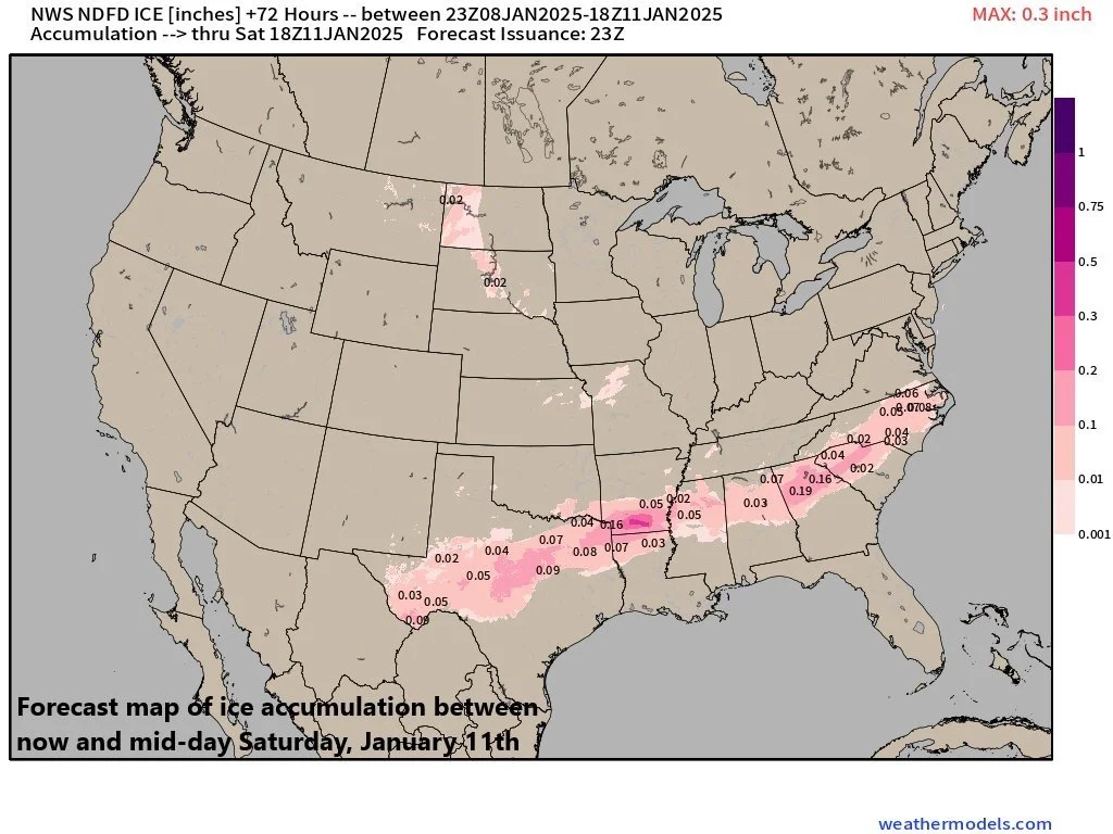
With cold air now firmly in place all the way to the Gulf coast, this developing storm system is already producing snow in places like Dallas, TX and Oklahoma City, OK and will produce significant snow and ice over the next couple of days across the southern states all the way from New Mexico to Virginia. In fact, the snow can accumulate as high as half a foot or more in some parts of Texas, Oklahoma, Arkansas and Tennessee causing widespread travel problems by Friday. In addition, ice can accumulate as much as a quarter of an inch in some places resulting in hazardous travel and the risk of downed trees and scattered power outages.
In addition to significant snow in some areas, ice accumulation will become a problem for parts of the southern US during this upcoming event. The threat for a glaze of ice will likely extend all the way from Texas to the Carolinas and it can result in some very hazardous driving conditions as well as scattered power outages. Map courtesy NOAA, weathermodels.com (Dr. Ryan Maue, X)
After producing a major impact on the southern states, this low pressure system will likely reach the coastal waters of the Carolinas by early Saturday as it moves on a general east-northeast track. While support in the upper-atmosphere will be somewhat limited along the east coast for the surface low pressure in terms of its ability to generate significant upward motion, accumulating snow is likely to overspread the DC-to-Philly-to-NYC corridor by later Friday night and continue into Saturday morning.
The preliminary estimates for the timing of the snow arrival in the Mid-Atlantic’s I-95 corridor and the overall accumulation amounts are follows:
DC metro region:
arrival time around 9PM on Friday night; 1-3 inches by Saturday morning
Philly metro region:
arrival time around midnight on Friday night; a coating to 2 inches by Saturday morning
NYC metro region:
arrival time around 3AM on Saturday; a coating to an inch or so by Saturday morning
High pressure and more cold air will follow into the eastern states for the early part of next week as the colder-than-normal weather pattern continues across much of the nation.
Meteorologist Paul Dorian
Arcfield
arcfieldweather.com
Follow us on Facebook, Twitter, YouTube
Video discussion:


