**An energetic pattern setting up for late next week into early November...a cold air mass, tropical activity, and a “buckling” jet stream**
Paul Dorian
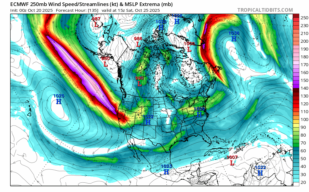
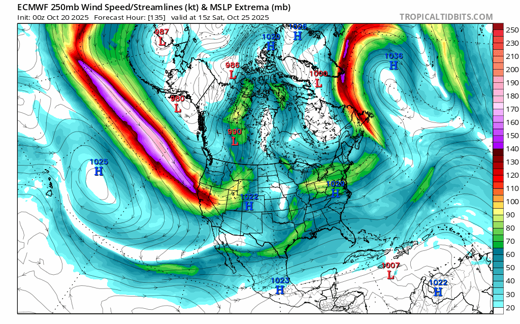
A powerful jet streak over the northern Pacific Ocean will enter the Pacific NW region by the weekend. This jet streak has been pushing in a general west-to-east fashion, but it will take a dive to the south and east later next week as its associated deep upper-level trough encounters very strong “blocking” in the atmosphere over central Canada. Maps courtesy ECMWF, tropicaltidbits.com (loop of 250 millibar winds extends from Saturday AM, October 25th to Wednesday PM, October 29th)
Overview
There have been some notable storms near the east coast during the late stages of October and early parts of November including Hurricane Sandy in 2012, the so-called “Perfect Storm” in 1991, and Hurricane Nicole in 2022 which made landfall in Florida. It is at this time of year where there can be a “last gasp” from the Atlantic Basin tropical season as water is still quite warm in places like the Caribbean Sea, and southwestern Atlantic Ocean. At the same time, there is often an increasing frequency of chilly air masses moving from Canada into the US warning us that winter is not too far away. It is this combination of a waning tropical season combined with increasingly winter-like chill that can cause volatile weather patterns in late October and early November and we could be setting up for something like that for late next week into the beginning of November.

A strong tropical wave now situated over the eastern Caribbean Sea has an excellent chance of becoming a named tropical storm in coming days (would be “Melissa”). In fact, intensification into hurricane status of this system is likely and attainment of “major” hurricane status (i.e., category 3 or higher) is even on the table. Images courtesy NOAA/GOES-East
Details
Sea surface temperatures are generally in the middle-to-upper 80’s across the Caribbean Sea which is above-normal for this time of year and still very supportive of development and intensification of tropical systems at this late stage of the tropical season. In fact, there is a strong tropical system that has reached the eastern Caribbean Sea and it has an excellent chance of becoming a named tropical storm in coming days (would be “Melissa”). In fact, as it treks over the very warm waters of the Caribbean Sea in coming days, this tropical system has a good chance of reaching hurricane status and perhaps even an eventual attainment of “major” hurricane classification (category 3 or higher). Eventually, this tropical system could cross the island of Cuba and move into the southwestern Atlantic Ocean and likely remain well off the US east coast. Even if this tropical system stays away from the east coast, it is possible that some tropical moisture works its way to the north and west and to the east coast depending on exactly how this evolving pattern plays out.

While we are at the latter stages of the tropical season, water temperatures are still quite warm in the Caribbean Sea (mid-to-upper 80’s) and fully capable of supporting the development and intensification of a tropical system. Map courtesy NOAA, tropicaltidbits.com
By this weekend, a powerful jet streak that moves in a general west-to-east fashion over the northern Pacific Ocean will likely push into the northern California/Oregon area and rain is likely to break out along coastal sections and strong in the inland higher elevation locations. By early next week, this jet streak and its associated upper-level trough will begin to dive to the south and east as tremendous “blocking” in the atmosphere sets up across northern Canada. As a result, the middle and latter part of next week is likely to feature a very deep upper-level low centered over the upper Midwest and anomalously strong upper-level ridging stationed over central Canada. This upper-level trough will feature some quite chilly air for this time of year that might make its way all the way down to the Gulf states. It is at this same time that the tropical system aforementioned – likely Hurricane Melissa by now – should be over the southwestern Atlantic and some of its tropical moisture could be pulled to the north and west by this deep upper-level trough positioned over the Midwest by late next week.

The middle of next week could feature a deep upper-level trough of low pressure centered over the Upper Midwest, powerful “blocking” positioned over central Canada with anomalous higher heights compared to normal, and a tropical system over the northwestern Caribbean Sea…an energetic pattern. Map courtesy ECMWF, tropicaltidbits.com
It is too early to say how this all turns out but suffice to say the overall pattern looks quite energetic as we wind down October and begin the month of November. Depending on the timing of the cold air influx, it is not out of the realm of possibility that some snow falls in higher elevation locations of the Northeast US and severe weather may be on the table during this period in portions of the central and/or eastern US. As a footnote, Hurricane Sandy was associated with an incoming cold air mass in late October of 2012 and contributed to a few feet of snow in some of the higher elevations of West Virginia.
Stay tuned...often the “last gasp” of the Atlantic Basin tropical season is followed by a cold air intrusion into the central and eastern US which can be a “pattern-changer” to more winter-like weather conditions…we’ll see how this plays out, but we could very well be setting up for a cold first week of November across much of the eastern half of the nation.
Meteorologist Paul Dorian
Arcfield
arcfieldweather.com
Follow us on Facebook, Twitter, YouTube
Video discussion: