
**A powerful jet streak, intense blocking, cold air intrusion, and a likely Hurricane (Melissa)...ingredients for an energetic weather pattern from later next week into the following week**
Paul Dorian

Tropical Storm Melissa has formed over the Caribbean Sea…the first tropical storm of the season in that part of the Atlantic Basin. TS Melissa had been moving rather quickly in recent days, but it should slow down quite a bit in the near-term and giving it an excellent chance of intensifying into hurricane status over very warm water. Images courtesy NOAA/GOES-East
Overview
The European model run on Monday morning produced some stunningly high rainfall amounts of a foot or more in much of the Mid-Atlantic region for the 5-day period ending on Saturday, November 1st. Meanwhile, the Canadian model run from Monday night featured what is likely to be a hurricane (Melissa) producing accumulating snow over some of the higher elevations of the Northeast US late next week after it shifts northwest towards the New England coastline and encounters an unusually cold air mass. While odds are against either of these scenarios coming to fruition, they do suggest to me that the models are correctly sniffing out the potential for some energetic weather from later next week into the following week and there are several ingredients likely to come into play for just such a pattern. The ingredients include a powerful jet streak that will push into the western US this weekend from the northern Pacific Ocean, intense blocking in the upper part of the atmosphere that is likely to develop across central Canada by the middle of next week, a cold air intrusion into the US from Canada, and a likely hurricane over the western Atlantic Ocean.

The 12Z Euro model run from Monday morning (left) featured stunningly high rainfall amounts in the 5-day period leading up to Saturday, November 1st and the 00Z Canadian model run (right) from Monday night featured a likely hurricane nearing the New England coastline by late next week and even some snow (shown in blue) across portions of the Northeast US. While odds are against either scenario coming to fruition, these model runs are sending a red flag that there is real potential in this evolving pattern for some active weather as October winds down and November gets underway. Maps courtesy ECMWF, Pivotal Weather (left); Canadian Met Centre, tropicaltidbits.com (right)
Tropical Storm Melissa
Sea surface temperatures are generally in the middle-to-upper 80’s across the Caribbean Sea which is above-normal for this time of year and still fully supportive of development and intensification of tropical systems at this late stage of the tropical season. In fact, a strong tropical wave has just been officially named (Melissa) by NOAA’s National Hurricane Center having climbed to tropical storm status with maximum sustained winds of 50 mph...this is the first tropical storm so far this year in the Caribbean Sea.
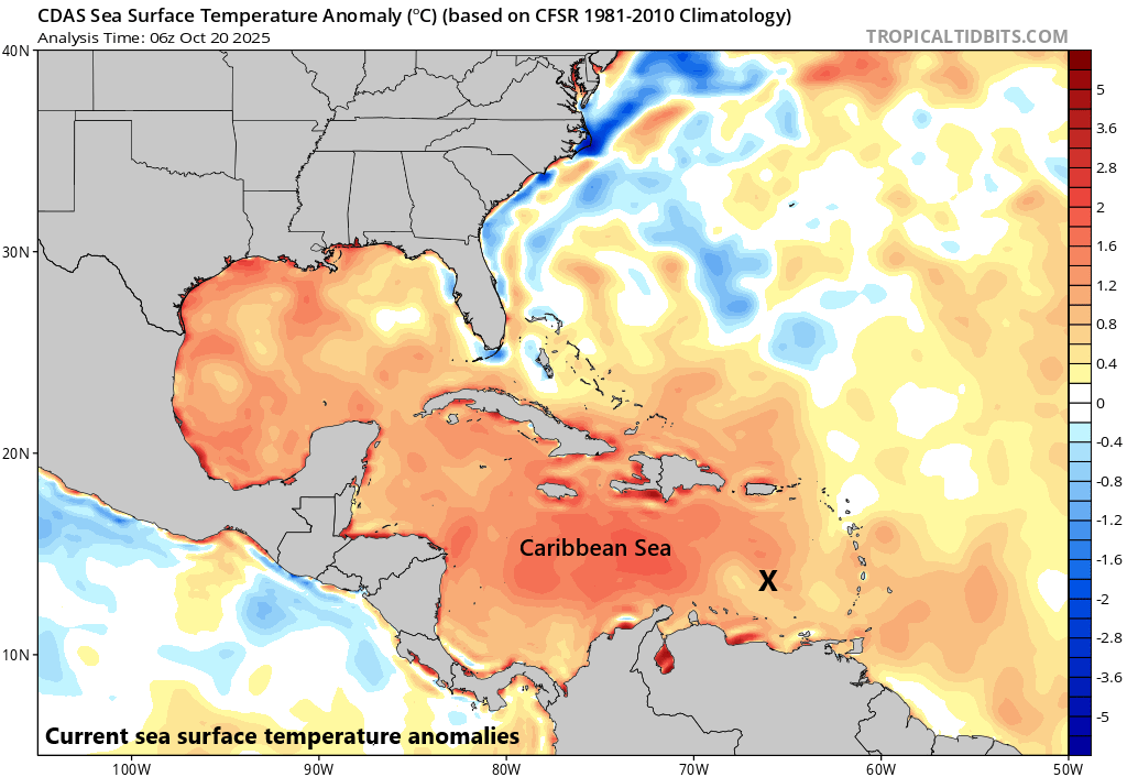
While we are at the latter stages of the tropical season, water temperatures are still quite warm in the Caribbean Sea (mid-to-upper 80’s) and are fully capable of supporting the intensification of a tropical storm into a hurricane. Map courtesy NOAA, tropicaltidbits.com
This tropical storm has been moving at a fairly rapid clip in recent days, but it should slow down quite a bit in the near-term and this will give it a great chance of becoming a hurricane as it drifts over some very warm water. In fact, if the system can spend several more days over the warmer-than-normal water of the central/western Caribbean Sea, it has an outside chance of reaching “major” hurricane status (i.e., category 3 or higher). Tropical Storm Melissa is likely to close in on Jamaica by later in the weekend and could ultimately cross over the eastern part of Cuba on its way to the open waters of the southwestern Atlantic Ocean...and likely remaining away from the US east coast. However, even if the center of this potential hurricane stays away from the east coast, it is possible that some of its tropical moisture can work its way back to the west and possibly have an impact on the weather in the eastern US.
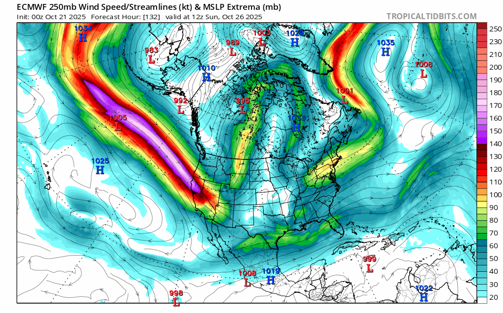
A powerful jet streak over the northern Pacific Ocean will enter the Pacific NW region by the weekend. This jet streak has been pushing in a general west-to-east fashion, but it will take a dive to the south and east later next week as its associated deep upper-level trough encounters very strong “blocking” in the atmosphere over central Canada. Maps courtesy ECMWF, tropicaltidbits.com (loop of 250 millibar winds extends from Sunday AM, October 26th to Tuesday PM, October 28th)
Powerful jet streak over northern Pacific...intense blocking to form over Canada
Meanwhile, far to the northwest of the Caribbean Sea, another important player will be coming into focus this weekend and that is a powerful jet streak that will be closing in on the northern part of California from the northern Pacific Ocean. A strong storm system - spawned in large part by this upper-level jet streak - will move from the Gulf of Alaska to the Pacific NW by this weekend and likely generate rain in low-lying areas and snow in higher-elevation inland locations.
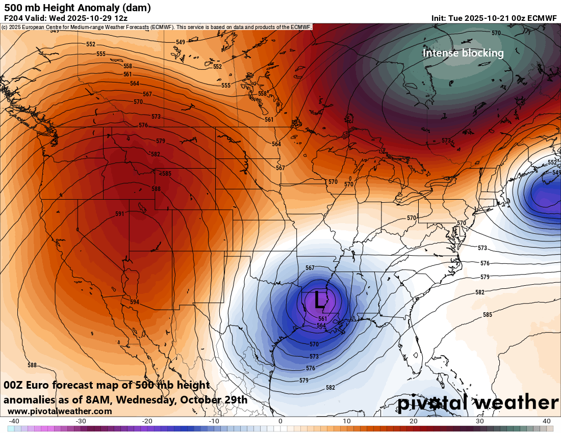
Intense blocking in the upper part of the atmosphere will form over central/eastern Canada by the middle of next week and it’ll play an important role in the overall weather pattern across the central and eastern US. Map courtesy ECMWF, Pivotal Weather
By early next week, this upper-level jet streak will begin to “buckle” and its associated upper-level trough will dive to the south and east as tremendous blocking sets up aloft over central Canada. As a result, the middle and latter part of next week is likely to feature a deep upper-level low trough centered over the Lower Mississippi Valley and anomalously strong upper-level ridging will be positioned over central Canada. This upper-level trough will feature some quite chilly air for this time of year that might make its way all the way down to the Gulf states. It is at this same time that the tropical system – likely Hurricane Melissa by now – should be over the southwestern Atlantic Ocean and some of its tropical moisture can be pulled to the north and west by this deep upper-level trough positioned over the Lower Mississippi Valley.

The first week of November could feature some much colder-than-normal air across the central and eastern US. Sometimes the last gasp of the Atlantic Basin tropical season ends with an influx of colder-than-normal air into the central and eastern states and it becomes a “pattern-changer” with more winter-like conditions to follow. Maps courtesy NOAA, Weather Bell Analytics
Cold air influx during early November into central and eastern US
It is too early to say how this all turns out but suffice to say the overall pattern looks quite active as we wind down October and begin the month of November. Depending on the timing of the cold air influx, it is not out of the realm of possibility that some snow falls in higher elevation locations of the Northeast US [Note - Hurricane Sandy was associated with an incoming cold air mass in late October of 2012 and contributed to a few feet of snow in some of the higher elevations of West Virginia]. Often the “last gasp” of the Atlantic Basin tropical season is followed by a widespread cold air intrusion into the central and eastern US which can be a “pattern-changer” to more winter-like weather conditions going forward…we’ll see how all of this plays out, but we could very well be setting up for a cold air outbreak by the first full work week of November across much of the eastern half of the nation.
Meteorologist Paul Dorian
Arcfield
arcfieldweather.com
Follow us on Facebook, Twitter, YouTube
Video discussion: