
**TS Melissa continues to drift over the Caribbean...“category 5" classification on the table...active pattern next week to feature powerful jet streak, intense blocking, cold air, and a hurricane**
Paul Dorian

One key player in next week’s active weather pattern will be an intense “block” in the atmosphere centered over Canada. This “block” in the atmosphere over Canada will “force” an upper-level jet streak to take a dive to the south and east into the south-central part of the country where a deep trough will form by later next week. Map courtesy Canadian Met Center, tropicaltidbits.com
Overview
Tropical Storm Melissa continues to drift today over the warm waters of the Caribbean Sea and will likely do so for several days to come. There has been no intensification of the tropical system during the past 24 hours or so as it is in an area featuring strong westerly vertical wind shear. Wind shear in the general vicinity of the circulation center of Tropical Storm Melissa is likely to diminish over the upcoming weekend which should allow for intensification of the system into a minimal hurricane, and a strengthening to “major”, category 5 status is certainly on the table by early next week. Ultimately, this tropical system will take a turn to the north - likely crossing over central/eastern Cuba - on its way to the western Atlantic Ocean. An active weather pattern next week will feature a powerful jet streak, intense blocking in the atmosphere centered over Canada, plenty of colder-than-normal air, an intensifying upper-level trough over the central and eastern US, and Hurricane Melissa. There is quite likely going to be some kind of interaction between the inland upper-level trough and the western Atlantic Ocean hurricane, and a “late in the game” turn to the northwest by the tropical system cannot be completely ruled out.
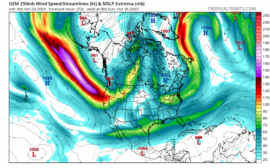
A key player in the active weather pattern expected next week will be a powerful upper-level jet streak that will slam into northern California from the northern Pacific Ocean and then it’ll be “forced” to take a dive to the south-central states as it becomes increasingly influenced by the intense blocking in the atmosphere centered over Canada. Maps courtesy Canadian Met Centre, tropicaltidbits.com
Details
Tropical Storm Melissa continues to move slowly over the central Caribbean with north-northwest motion at 2 mph and maximum sustained winds of 45 mph. There has been no intensification during the most recent 24 hour period with Tropical Storm Melissa in an environment featuring strong westerly vertical wind shear. As such, the wind field of the tropical storm is “lopsided” with most of the strong winds confined to the eastern half of the circulation. There is likely to be little, if any, intensification of Tropical Storm Melissa during the next 24 hours or so; however, there will be important changes in the overall environment by the early part of the weekend.

One of NOAA’s hurricane models known as the “Hurricane Analysis and Forecasting System (HAFS)” depicts a powerful hurricane on Monday morning, October 27th, just to the southwest of Jamaica with a central pressure of 905 millibars. Map courtesy NOAA, Weather Bell Analytics (Meteorologist Joe Bastardi, X)
On Saturday, the vertical wind shear in the atmosphere in the vicinity of Tropical Storm Melissa should begin to relax, and this change should allow for strengthening to hurricane status as this storm continues to drift over the warm waters of the Caribbean Sea. In fact, intensification to “major”, category 5, levels is quite possible by late in the weekend or the early part of next week. The path of Tropical Storm Melissa during the next few days is likely to bring it to a position just to the south/southwest of Jamaica where major impacts are likely, and there can be substantial impact to at least the western side of Haiti. Ultimately, a turn to the north is quite likely which could involve a crossing over of central/eastern Cuba by a “major” hurricane sometime during the early part of next week. After that, Melissa will move out over the still-warm waters of the southwestern Atlantic Ocean.

One of NOAA’s hurricane models known as the “Hurricane Analysis and Forecasting System (HAFS)” depicts a powerful hurricane on Monday morning, October 27th, just to the southwest of Jamaica with very strong wind gusts. Map courtesy NOAA, Weather Bell Analytics (Meteorologist Joe Bastardi, X)
Looking ahead to next week, the overall weather pattern across North America becomes very active to say the least. Multiple players will be on the field including a powerful jet streak that pushes from the northern Pacific Ocean into the northern part of California. This jet streak will then take a dive to the south and east as it becomes increasingly influenced by intense blocking forming over central Canada. In response to the arrival of the jet streak, an upper-level trough will intensify over the south-central US, and it’ll edge slowly to the eastern states by later next week. Meanwhile, Melissa – likely a strong hurricane at this time – will probably be moving northward over the western Atlantic Ocean and there certainly can be some kind of an interaction between the deepening inland upper-level trough and the western Atlantic Ocean tropical system. Exactly how this plays out remains to be seen, but some tropical moisture can certainly get infused into the inland trough - even with the tropical system well off the east coast - and a “late in-the-game” turn to the northwest by the hurricane cannot be completely ruled out...stay tuned.
Meteorologist Paul Dorian
Arcfield
arcfieldweather.com
Follow us on Facebook, Twitter, YouTube
Video discussion: