
***Numerous signals point to a colder-than-normal start to the winter season...a look at the MJO, NAO, AO, EPO, WPO, and a potential rare November Stratospheric Warming Event***
Paul Dorian

An index known as the Madden-Julian Oscillation which tracks a tropical disturbance as it propagates around the world is forecasted to move into locations or “phases” late this month/early December which are typically correlated with colder-than-normal conditions across much of the northern US. Map courtesy NOAA, ECMWF
Overview
An Arctic air mass that originated near the North Pole has infiltrated the eastern states today and it will have an impact all the way down to southern Florida by Tuesday morning. In fact, temperatures on Tuesday morning are likely to bottom out in the 30’s across the central part of the Sunshine State and the 40’s in southern Florida. At the same time, many suburban locations along the Mid-Atlantic’s I-95 corridor region from DC-to-Philly-to-NYC will feature the first hard freeze of the season with overnight lows well down in the 20’s in many spots. There is accumulating snow to go along with this early week Arctic blast with favored areas including the Great Lakes, interior sections of the Mid-Atlantic and Northeast US, and the central Appalachians where a vigorous upper-level low is helping to destabilize the atmosphere in a big way.
While there will likely continue to be colder-than-normal temperatures across the northeastern states during the second half of the week, this winter-like pattern does not look like it’ll continue through November. In fact, there are signs for warmer-than-normal conditions to cover much of the nation from next week into the following week and it may include one or more severe weather outbreaks as well. Looking farther down the road, numerous signals point to a sustained colder-than-normal period to start the winter season as we transition into the month of December.

An Arctic blast has reached the eastern US and it will have an impact by tomorrow morning all the way down to southern Florida. There will likely be numerous low temperatures records early Tuesday in this unusual early season cold air outbreak; especially, from the Carolinas to Florida. Map courtesy NOAA, tropicaltidbits.com
Details
The next couple of days will feature very cold weather for this time of year across much of the eastern US and no doubt there will be numerous record or near record lows on Tuesday morning; especially, from the Carolinas southward to Florida. This Arctic blast is being accompanied by an impressively strong upper-level low with rarely seen temperatures at mid-levels of the atmosphere for this time of year over the central Appalachians. There will be some reinforcing shots of chilly air later this week for the northeastern quadrant of the country, but much of the second half of the month is likely to feature warmer-than-normal conditions across a wide part of the nation. In fact, this warmer period across much of the nation might just include one or two severe weather outbreaks as we progress from mid-month to the latter part of November. It is beyond this period – as we switch the calendar to December – that numerous signals point to as becoming colder-than-normal over a large part of the northern US and it could be for a rather sustained period. Many of these signals were highlighted in the 2025-2026 Winter Outlook in which we emphasized the likelihood of a colder-than-normal winter for much of the nation.
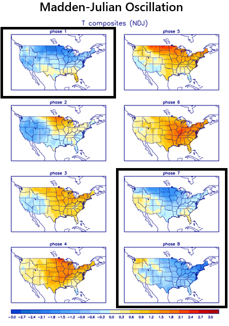
Different “phases” or locations of the Madden-Julian Oscillation are often well correlated with specific temperature patterns across the US depending on the time of year. In the early stages of the winter season, an MJO that moves into “phases 7, 8 and 1” is often correlated with colder-than-normal weather conditions across much of the northern US. Map courtesy NOAA
MJO
Meteorologists track an oceanic-atmospheric phenomenon known as the Madden-Julian Oscillation or MJO which affects weather patterns across the globe. Unlike El Nino or La Nina which are stationary features in the equatorial Pacific Ocean, the MJO is an eastward moving disturbance of clouds, rainfall, winds and pressures that traverse the planet in the tropics and returns to its initial starting point in 30 to 60 days, on average. The MJO was first discovered in the early 1970s by Dr. Roland Madden and Dr. Paul Julian when they were studying tropical wind and pressure patterns.
The MJO consists of two parts or phases with one being the enhanced rainfall (convective) phase and the other being the suppressed rainfall phase. The location of the convective phases is often grouped into geographically based stages that are numbered 1-8 by scientists. The location or phase of the MJO can be tied to specific weather patterns in different parts of the world depending on the time of year.
By late November, many computer model forecasts of the MJO place it into Phase 7 which is often a cold signal for the central and eastern US. Beyond that, it appears the MJO will continue to move into Phase 8 and potentially into Phase 1 – both of which are typically correlated with colder-than-normal weather during the beginning stage of the winter season.

There are early signs for a stratospheric warming event in late November which can lead to a weakening or a disruption of the polar vortex which can, in turn, increase the chances for cold air outbreaks to make their way from Canada into the US. The arrow on this temperature forecast map for late November points to an area of substantial warming in the stratosphere (10 millibar level) and this warming could shift to the North Pole region by early December. Map courtesy NOAA
Potential “Sudden Stratospheric Warming (SSW)” event
Stratospheric warming is a naturally occurring phenomenon that takes place in the northern hemisphere winter season and potentially on multiple occasions. Typically, temperatures are very cold in the stratosphere over the polar region during the northern hemisphere winter, but periodically, warming takes place which can disrupt the polar vortex. In some cases, the polar vortex is displaced from its location to a position farther from the pole; in other cases, it is broken up into multiple pieces or simply weakened significantly.
There are early signs that a stratospheric warming event may indeed take place in late November or early December - unusually early for this to occur - and this could result in a weakening or a disruption of the polar vortex. For example, many ensemble members of the European computer forecast model actually reverse the zonal mean winds in the stratosphere which signals the potential of a stratospheric warming event. In these cases where the polar vortex is weakened or disrupted due to stratospheric warming, cold air masses that are usually confined to the high latitudes can be unleashed onto the middle latitudes and this could very well set the table for the central and eastern US as we begin the winter season in early December.

Two teleconnection indices known as the North Atlantic Oscillation (NAO, top plot) and Arctic Oscillation (AO, bottom plot) will likely spend a sustained period in negative territory later this month which often is well correlated with “high-latitude blocking” and this would favor cold air outbreaks from Canada into the US. Plots courtesy NOAA
“High-Latitude Blocking (HLB)” and signals from indices such as the NAO, AO
“High-Latitude Blocking” in the atmosphere is tracked by meteorologists through teleconnection indices such as the Arctic Oscillation (AO) and its closely related cousin called the North Atlantic Oscillation (NAO). The AO and NAO teleconnection indices refer to temperature and pressure patterns in the middle and high latitudes and can bounce between “positive” and “negative” values.

European model forecasts of 850 temperature anomalies suggest a colder-than-normal start to the winter season across much of the northern US with both the first full week of December (left map) and second full week (right map) below-normal. Maps courtesy ECMWF, Weather Bell Analytics
When these two indices are simultaneously in “negative” territory for extended periods of time during a winter season, the prospects for HLB tends to increase. “High-latitude blocking” is characterized by tenacious high pressure in northern latitude areas such as Greenland, northern Canada, and Iceland, weaker zonal winds, and greater movement of polar air into the middle latitudes such as the Mid-Atlantic region – and, in turn, an increased chance of snow. Indeed, the current model forecasts for the NAO and AO signal sustained “negative” levels as we progress through the second half of November which, in turn, could pave the way for a colder-than-normal start to the winter season.
Stay tuned...we’ll continue to monitor all of these trends during the next couple of weeks.
Meteorologist Paul Dorian
Arcfield
arcfieldweather.com
Follow us on Facebook, Twitter, YouTube
Video discussion: