
***A rare early season “Stratospheric Warming” event and a disruption of the polar vortex...a look at widespread cold that followed in two such other November events***
Paul Dorian
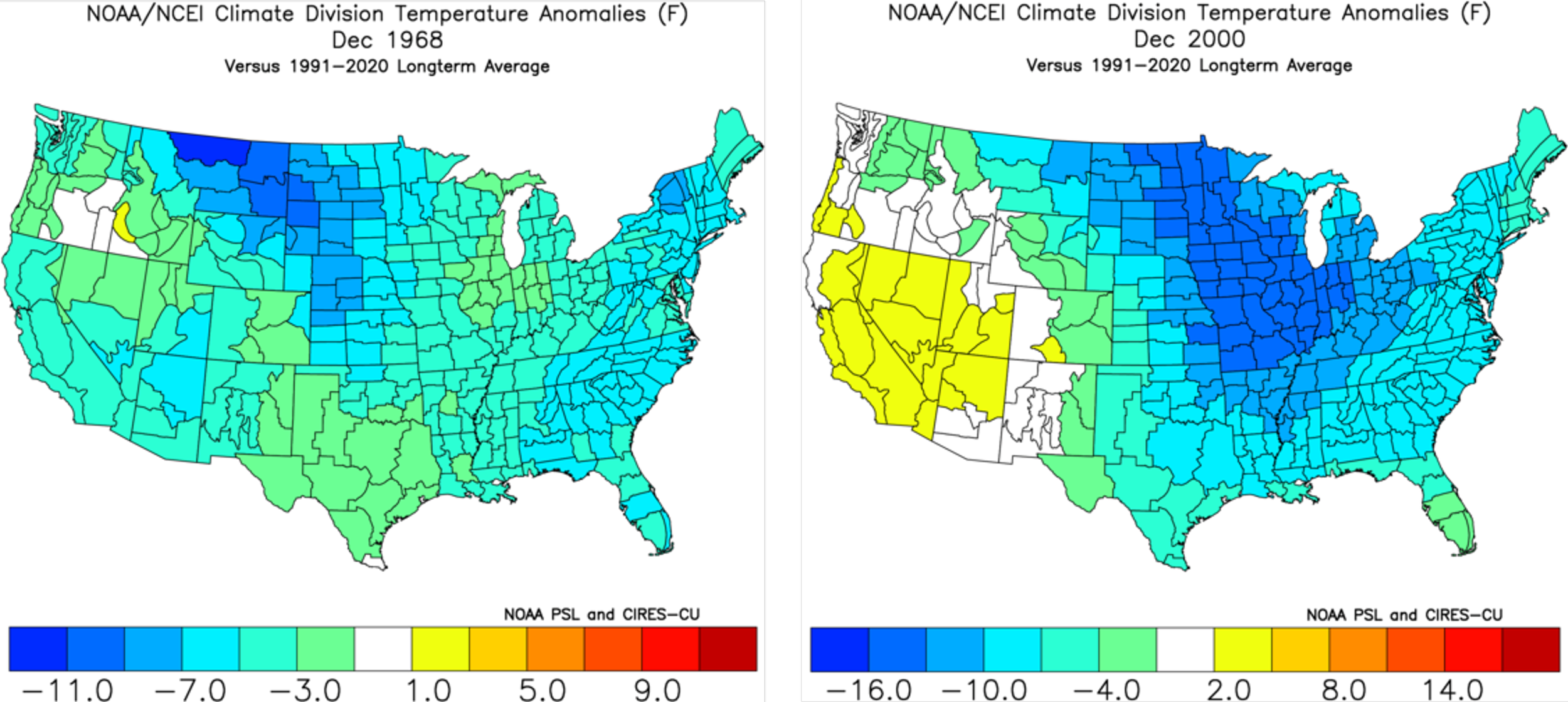
Stratospheric warming is rare early in the winter season and the two most recent “November” events…1968 (left) and 2000 (right)…were followed by widespread cold across much of the nation. Maps courtesy NOAA
Overview
There are signals that continue to point to an upcoming cold weather pattern for the central and eastern states as the early part of the winter season gets underway. These signs come from such diverse places as the stratosphere over the North Pole (re: Stratospheric Warming), the stratosphere over the tropics (re: QBO), and the equatorial part of the Pacific Ocean (re: MJO).
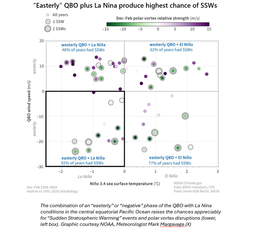
To begin, it appears as though there will be a “Stratospheric Warming” event over the polar region of the Northern Hemisphere in coming days which is quite a rare occurrence for this early stage of the winter season. In fact, it appears there have been only two Stratospheric Warming events in recent history that took place during the month of November...2000 and 1968...and in both of those years the month of December was quite cold across the nation. One atmospheric phenomenon that supports the idea of one (or more) “Stratospheric Warming” event(s) this winter season is known as the Quasi-Biennial Oscillation (QBO) which is a changing wind anomaly in the tropical lower stratosphere. When an “easterly” or “negative” phase of the QBO is combined with La Nina conditions in the tropical Pacific Ocean – both of which represent the current situation - there is a strong tendency for an increase in “Stratospheric Warming” events and the disruption of the polar vortex. This particular teleconnection was one of the factors highlighted in the ”2025-2026 Winter Outlook” issued back in October.
Additionally, there is an oceanic-atmospheric phenomenon known as the Madden-Julian Oscillation (MJO) that affects the weather patterns across the globe. The MJO is an eastward moving disturbance of clouds and rain that traverses the planet in the tropics and - depending on its location and the time of the year - it can contribute to colder-than-normal weather patterns across the central and eastern US.
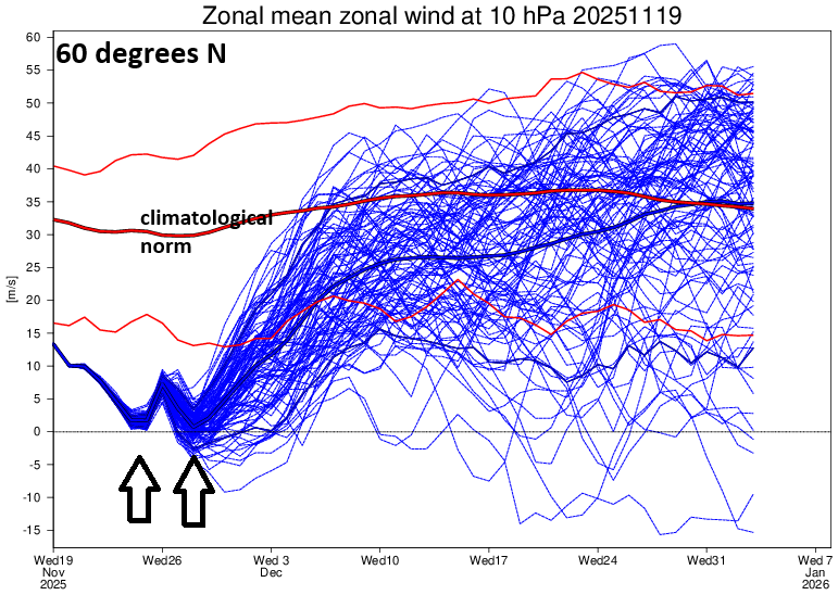
The westerly component of the stratospheric winds is quite strong in a stable polar vortex situation (thick red line on plot). However, when a stratospheric warming event takes place, there is a disruption or weakening of the polar vortex, and the westerly (or called zonal) winds can drop to near 0. In fact, it appears the zonal (westerly) winds at 60 degrees N will drop to near 0 on two occasions in the near-term just a few days apart (indicated with arrows). Map courtesy NOAA, ECMWF
Rare early winter Stratospheric Warming event and polar vortex disruption
Stratospheric warming is a naturally occurring phenomenon that takes place in the Northern Hemisphere winter season and potentially, on multiple occasions. Typically, temperatures are very cold in the stratosphere over the polar region during the Northern Hemisphere winter, but periodically, warming takes place which can disrupt the polar vortex. In some cases, the polar vortex is displaced from its location to a position farther from the pole; in other cases, it is stretched or broken up into multiple pieces or simply weakened significantly.
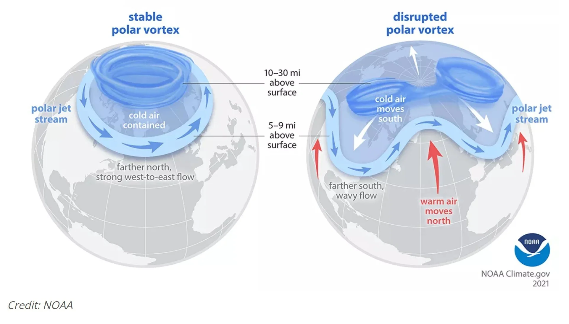
In a stable polar vortex circumstance (left), strong westerly (or zonal) winds surround the vortex to its south (e.g., at around 60 degrees N). In a Stratospheric Warming event, the polar vortex can become disrupted or weakened (right), the polar jet stream “buckles”, and this can unleash Arctic air masses from the high latitudes to the middle latitudes. Graphic courtesy NOAA
There are signs that a Stratospheric Warming event may indeed take place in coming days - unusually early in the winter season for this to occur - and this could result in a significant disruption of the polar vortex by “stretching” it out markedly. In these cases where the polar vortex is disrupted due to Stratospheric Warming, cold air masses that are usually confined to high latitudes can be unleashed onto the middle latitudes and this could very well be the case for the central and eastern US as we begin the winter season and potentially well into the winter season. (For more information on the Stratospheric Warming phenomenon check out the video on our Meteorology 101 page).
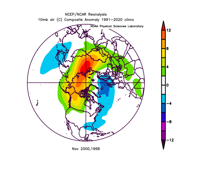
Two examples of November Stratospheric Warming events occurred in 1968 and 2000 and the 10 mb temperatures averaged well above-normal in the polar region. Map courtesy NOAA
In a look at back at recent history, it appears there were two Stratospheric Warming events that took place in the month of November with one being in the year 1968 and the other in the year 2000. In both cases, average temperatures in the polar region at the stratospheric level (i.e., 10 mb) averaged well above-normal for temperatures. And in both cases, the month of December that followed, featured widespread colder-than-normal conditions across much of the nation…something to watch for this year.
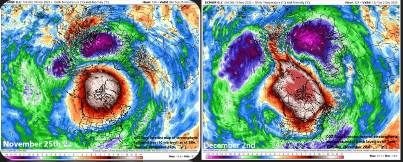
Significant stratospheric warming will take place in coming days and it appears it may happen on two occasions with a “relaxation” in between. The forecast map of 10 mb temperature anomalies on the left features significant stratospheric warming on November 25th and then a second such occurrence on December 2nd (right). Maps courtesy ECMWF
Quasi-Biennial Oscillation (QBO)
An atmospheric phenomenon known as the “Quasi-Biennial Oscillation” (QBO) is a changing wind anomaly in the tropical lower stratosphere. It has been found that strong stratospheric winds along an equatorial belt tend to completely change direction about every 14 months or so and this oscillation appears to play a crucial role in seasonal weather patterns as it can impact the polar vortex and the overall jet stream. Specifically, the tropical lower stratosphere winds flip from west-to-east or east-to-west every 14 months or so, an average period of about 28 months to return to the starting state.
Currently, the QBO features an east-to-west flow or what is known as a “negative” (easterly) phase. In fact, the QBO has been increasingly “negative” in recent months (-13.72 in June, -19.99 in July, -22.38 in August, -24.26 in September, and -24.65 in October) as calculated by NOAA’s Physical Sciences Laboratory for the zonally averaged 30 mb winds at the equator (credit NOAA (“Get Data/Time Series List”)). Recent upper air observations from NASA radiosondes suggest the “negative” QBO phase will likely continue during the upcoming winter season which is typically favorable for colder-than-normal weather in the eastern US.
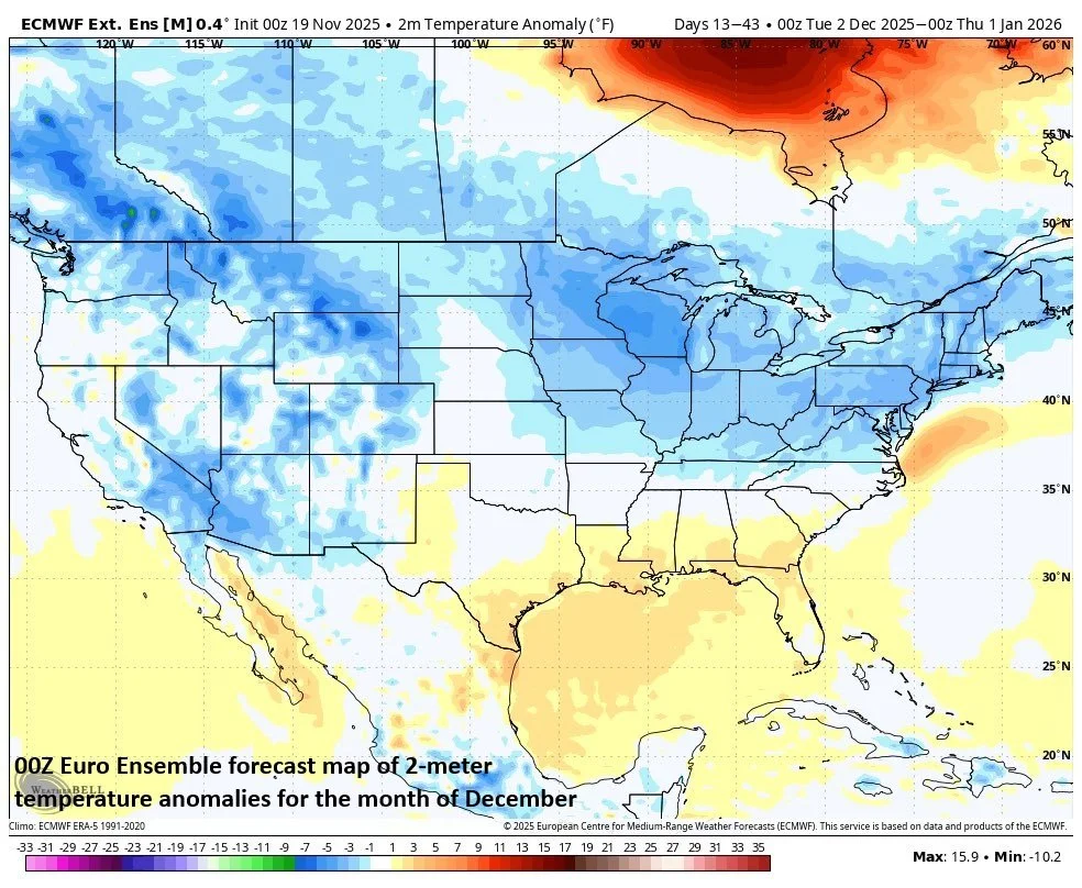
Somewhat similar to the two November Stratospheric Warming events in recent history (i.e., 1968, 2000), the following month of December is forecasted here to feature widespread cold across much of the nation. Map courtesy ECMWF, Weather Bell
When an “easterly” or “negative” phase of the QBO is combined with La Nina, there is a strong tendency for an increase in “Stratospheric Warming” events and the disruption of the polar vortex, a weaker Atlantic jet stream, and cold winters in northern Europe and the eastern US. Stratospheric Warming events and the disruption of the polar vortex in the Northern Hemisphere in winter characteristically increase the chance for Arctic air outbreaks to reach the lower latitudes from the higher latitudes. The “easterly” phase also encourages a negative North Atlantic Oscillation (NAO), which can funnel cold air into North America.
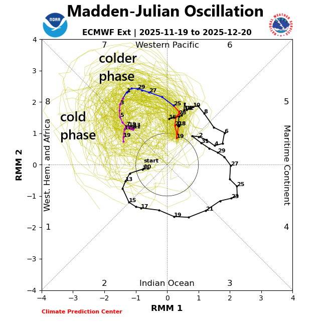
The Madden-Julian Oscillation or MJO is predicted to rotate into a chilly phase (7) for much of the US by late November and then into a cold phase (8) for much of the nation around the middle of December. Plot courtesy NOAA
Madden-Julian Oscillation (MJO)
Meteorologists track an oceanic-atmospheric phenomenon known as the Madden-Julian Oscillation or MJO which affects weather patterns across the globe. Unlike El Nino or La Nina which are stationary features in the equatorial Pacific Ocean, the MJO is an eastward moving disturbance of clouds, rainfall, winds and pressures that traverse the planet in the tropics and returns to its initial starting point in 30 to 60 days, on average. The MJO was first discovered in the early 1970s by Dr. Roland Madden and Dr. Paul Julian when they were studying tropical wind and pressure patterns.
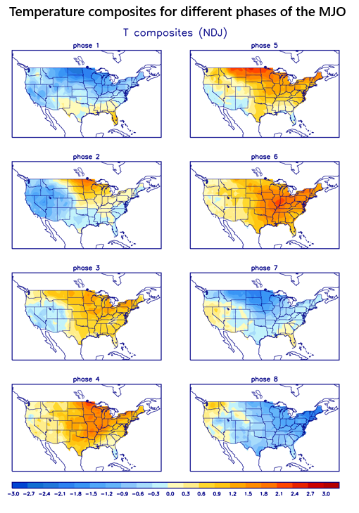
Phases 7, 8 and 1 are typically correlated with colder-than-normal conditions (shown in blue) across much of the nation during this time of year. Composites courtesy NOAA
The MJO consists of two parts or phases with one being the enhanced rainfall (convective) phase and the other being the suppressed rainfall phase. The location of the convective phases is often grouped into geographically based stages that are numbered 1-8 by scientists. The location or phase of the MJO can be tied to specific weather patterns in different parts of the world depending on the time of year.
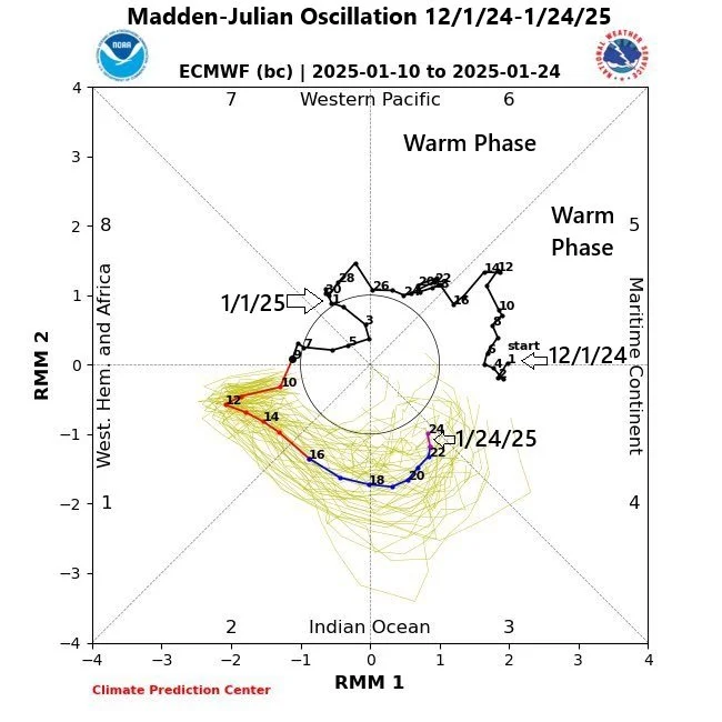
The MJO was in a different position during the month of December last winter with a rotation through (warmer) phases 5 and 6 between 12/1/24 and 1/1/25. Plot courtesy NOAA
By late November, many computer model forecasts of the MJO place it into Phase 7 which is often a relatively cold signal for the central and eastern US. Beyond that, it appears the MJO will move slowly to Phase 8 by about the middle of December, which is typically correlated with widespread cold during this stage of the winter season in the eastern two/thirds of the nation.
Stay tuned...the winter of 2025-2026 may be quite interesting indeed.

Meteorologist Paul Dorian
Arcfield
arcfieldweather.com
Follow us on Facebook, Twitter, YouTube
Video discussion: