****Great Lakes snow event...Great Lakes/Midwest snowstorm...Mid-Atlantic/NE US early week storm threat...wild weather coming Thanksgiving-to-Christmas****
Paul Dorian

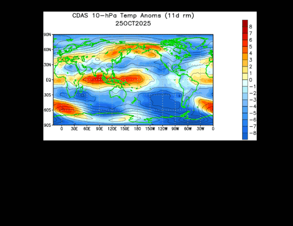
An unusual early season stratospheric warming event has taken place in the Northern Hemisphere causing a disruption (stretching) of the polar vortex and there may be additional bursts of warming (shown in orange) during the next several weeks. The disruption of the polar vortex can set off a chain events that ultimately help to unleash Arctic air masses from northern Canada into the US and, if history is any guide, that can result in some intense cold. This 30-day loop of 10 millibar temperatures (stratosphere) features a burst of warming (shown in orange) during the past several days in the polar region of the Northern Hemisphere. Maps courtesy NOAA
Overview
The period between Thanksgiving and Christmas will begin with a major Great Lakes snow event from Thursday to Friday and an Great Lakes/Midwest snowstorm this weekend and it could end with a White Christmas in many parts of the country. Two of the factors that have been highlighted here, likely leading to a cold and active stretch of weather, include an unusual early season stratospheric warming event and the likely movement of a tropical disturbance into a location that favors colder-than-normal conditions across a large part of the nation. Both of these phenomena – stratospheric warming and tropical forcing – will likely lead to a “buckling” of the polar jet stream which can lead to the unleashing of multiple Arctic air masses from northern Canada into the US (with intense cold in the table), and an activation of the southern branch of the jet stream which will likely produce multiple snow/ice threats.
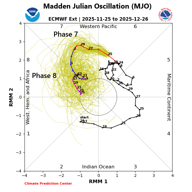
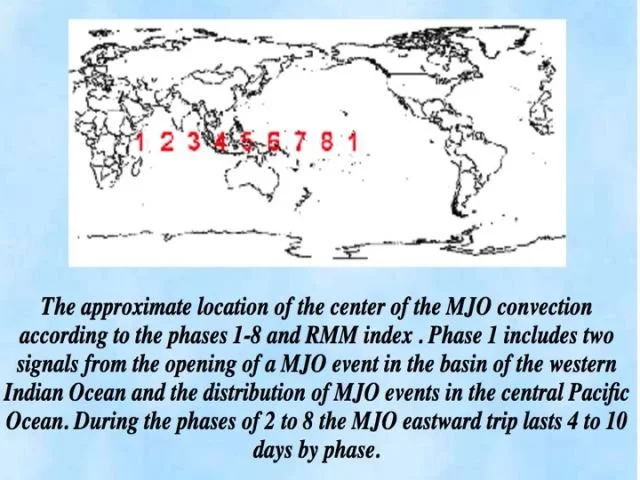
The Madden-Julian Oscillation or MJO will move through “phase 7” in coming days and then likely reach “phase 8” by the middle of December. Typically, a movement of the MJO into “phase 7” this time of year helps to set the stage for cold air to be delivered to the US, and “phase 8” is when the cold air is actually delivered on a consistent basis. Plot courtesy NOAA, ECMWF
Details
Some wild weather is on the table for the period from Thanksgiving to Christmas and it begins with an Arctic outbreak reaching the Great Lakes and northeastern states during the next 24 hours or so. Temperatures will be well below-normal on Thursday and Friday across the Great Lakes, Mid-Atlantic and Northeast US and the winds will become quite strong as well from a northwesterly direction. In terms of snow, this Arctic air outbreak will be the catalyst for another significant Great Lakes snow event in those areas just downstream of the still relatively warm waters and, in some locations, it may be quite intense with substantial lake-effect snow accumulations of a foot or more.
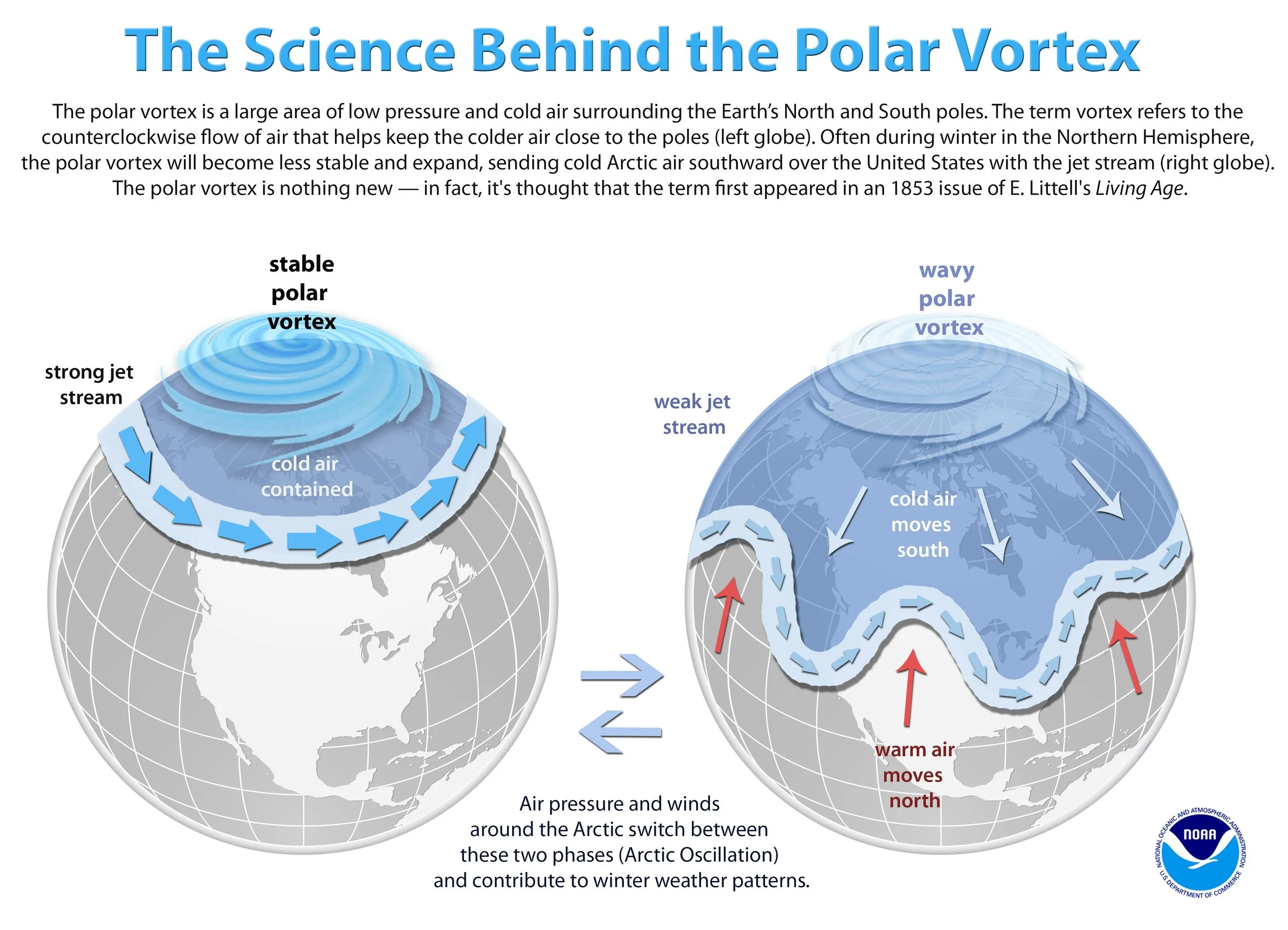
Stratospheric warming and the movement of the MJO into “phases 7 and 8” can help to disrupt the polar vortex from its stable state (left plot) which, in tun, leads to a “buckling” of the polar jet stream (right plot). A “buckling’ of the polar jet stream can help to unleash Arctic air masses into the US from northern Canada and it also increases the chance for storminess in the central and eastern US. Graphic courtesy NOAA
A sampling of places with the risk of heavy snowfall in the near-term when the Great Lakes “snow machine” gets turned on includes some of the usual suspects such as Marquette, MI, Cleveland, OH, Erie, PA, Buffalo, NY, and Watertown, NY. The combination of relatively warm lake water and Arctic cold flowing just above will act to destabilize the atmosphere which, in turn, will help to generate some intense snow bands. Some of the lake-effect snow bands can make their way pretty far downstream into such places as northeastern PA and eastern NY, and perhaps a few snow showers can reach into the immediate I-95 corridor.
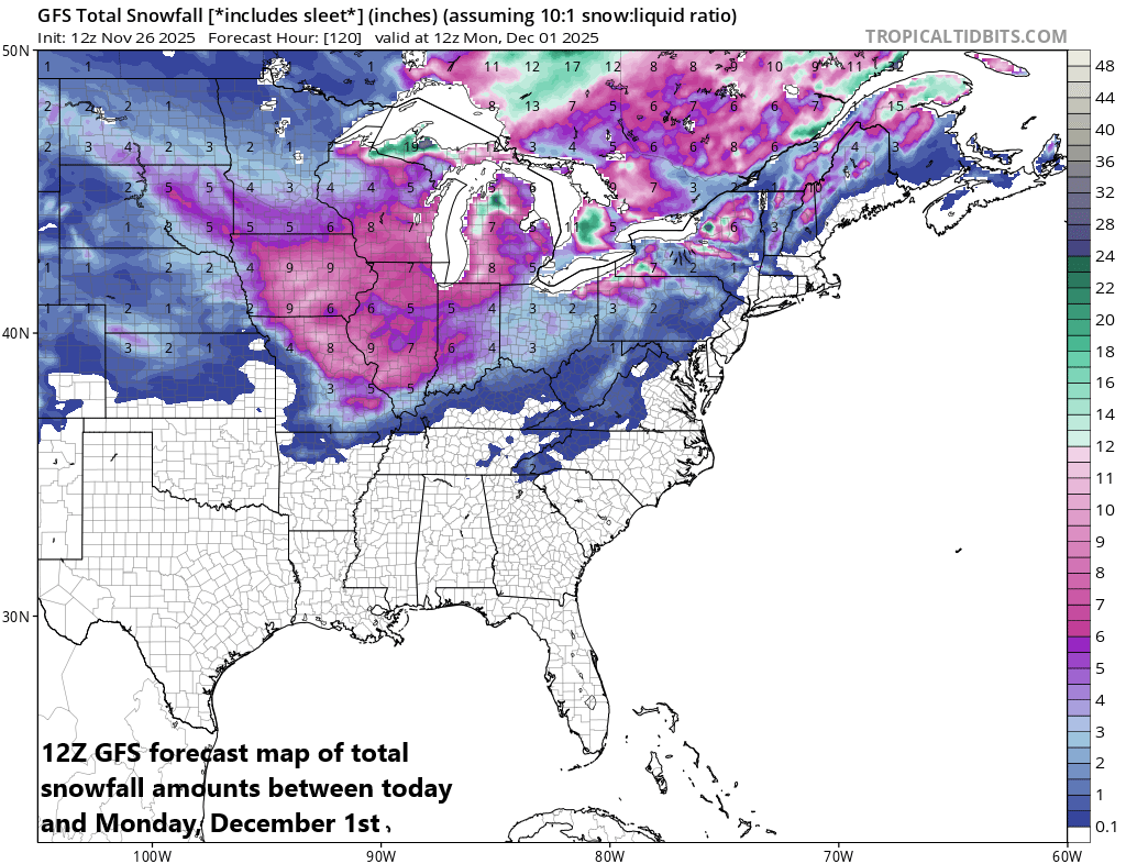
This forecast map of total snowfall amounts between now and Monday, December 1st, includes snow that falls during the Thursday/Friday Great Lakes snow event, and the weekend snowstorm in the Upper Midwest. Map courtesy NOAA
Right on the heels of the lake-effect snow event, a new storm system will push out of the middle of country by Saturday and head towards the Upper Midwest. This next storm system will encounter cold air on its north side likely resulting in a solid snowstorm across much of the Great Lakes and Midwest from central Illinois (including Chicago), northern Indiana, Iowa and Minnesota on the western side of the snow shield to Wisconsin and Michigan on the eastern flank (by the way, snow is possible by the latter part of the Ohio State-Michigan game on Saturday in Ann Arbor, MI). Farther south, this looks like a soaking rain event this weekend that will extend from the central Midwest all the way to the northern Gulf where there can be strong-to-severe thunderstorm activity.
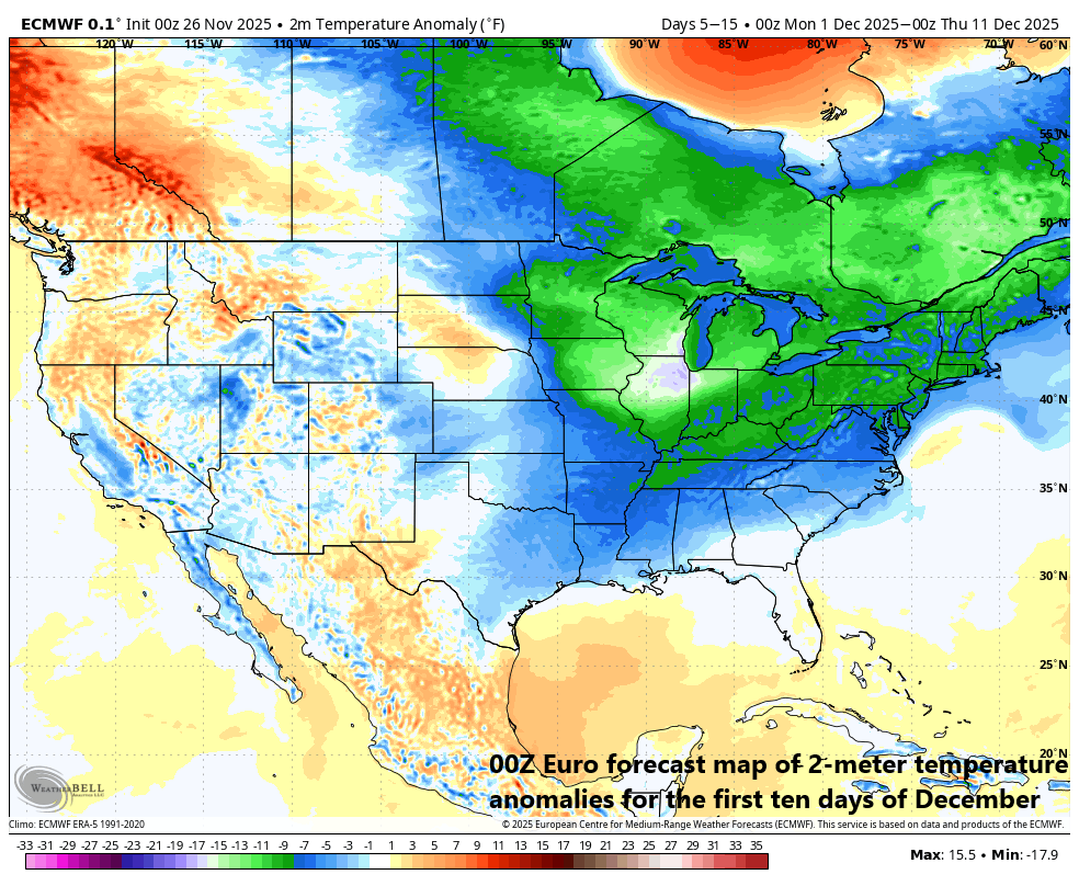
Numerous signals point to a colder-than-normal stretch of weather across much of the nation from Thanksgiving-to-Christmas (e.g., stratospheric warming, MJO rotation into colder phases). This 00Z Euro forecast map of 2-meter temperature anomalies is for the first ten days of the month of December with colder-than-normal conditions across the central and eastern US. Map courtesy ECMWF, Weather Bell Analytics
Looking ahead, yet another winter storm could threaten the Mid-Atlantic region and Northeast US by Tuesday or so of next week. The stage will be set with a cold frontal passage on Monday that should usher in a reinforcing shot of cold air to the Mid-Atlantic region and NE US. Low pressure will then likely ride up along the frontal boundary zone on Tuesday potentially bringing precipitation to the Mid-Atlantic region and Northeast US…the strength of the low is still just too early to determine. Temperatures are likely to be borderline in the immediate DC-to-Philly-to-NYC corridor on Tuesday so there certainly is a question at this point as to whether snow or rain will fall or some sort of combination of the two (best chance for snow would be northwest of I-95). In addition, there is the possibility that icing could become part of the equation with low-level cold air “seeping” into the I-95 corridor region on Tuesday...stay tuned, still several days away.
Get ready...it could be quite a wild ride between Thanksgiving and Christmas (and maybe beyond with the chance for another stratospheric warming event come late December ensuring more cold air for January and February.
Meteorologist Paul Dorian
Arcfield
arcfieldweather.com
Follow us on Facebook, Twitter, YouTube
Video discussion: