***Powerful wind event on Wednesday night Mid-Atlantic/Northeast US...Arctic blast early next week for the eastern US with first hard freeze in many spots...and some snow as well***
Paul Dorian

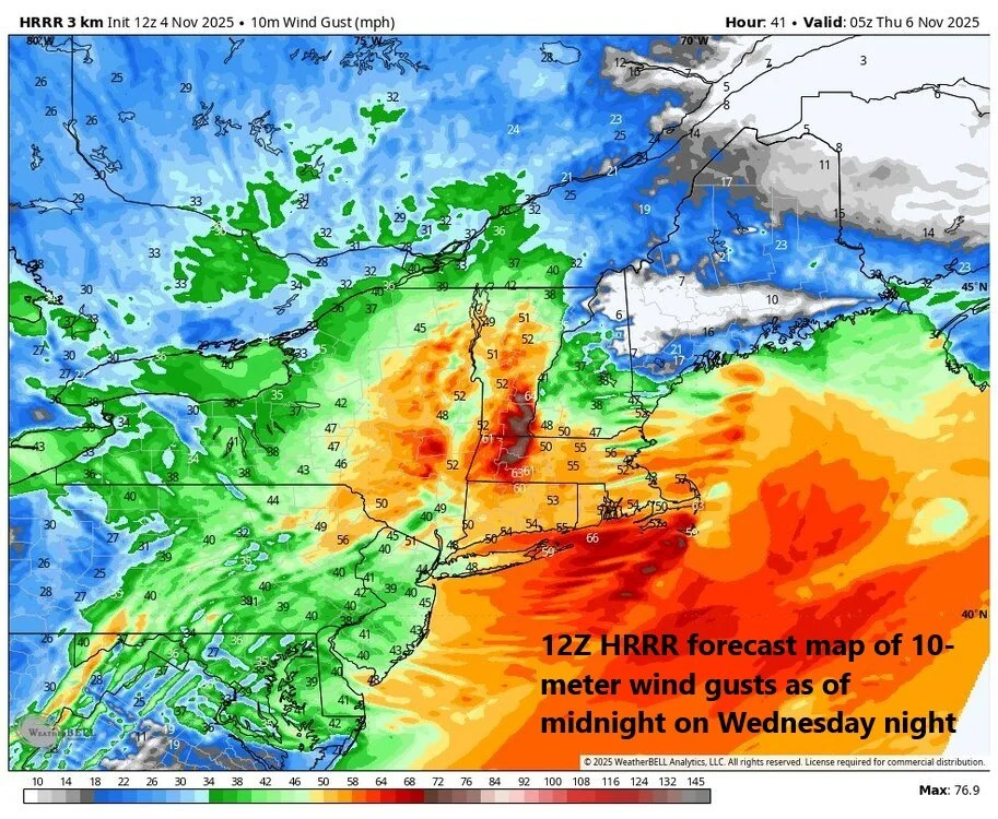
A powerful wind event is in store for much of the Mid-Atlantic region and Northeast US on Wednesday night associated with a strong cold front and intensifying low pressure. Wind gusts could top 60 mph in some spots which raises a red flag for the potential of some power outages in the northeastern states. Map courtesy NOAA, Weather Bell Analytics
Overview
An active weather pattern over the next several days will feature a powerful wind event on Wednesday night across many northeastern states and then an Arctic air mass will invade the eastern states early next week. The powerful winds on Wednesday night will be associated with an intensifying low-pressure system that forms along a strong cold frontal boundary zone and 60+ mph wind gusts are on the table for some locations. By the end of the upcoming weekend, another strong cold front will slide into the eastern states, and this system will usher in the coldest air of the season so far with the first hard freeze in many spots and accumulating snow will be possible across the Great Lakes, interior sections of the northeastern states.

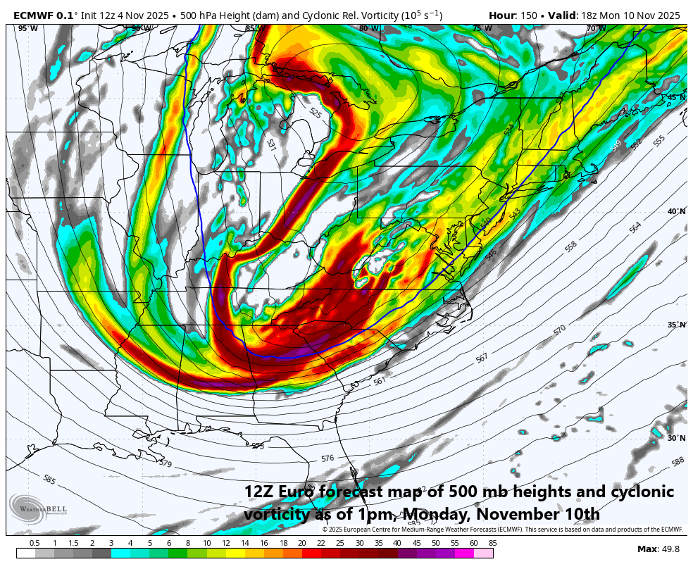
Arctic air will invade the eastern US early next week likely resulting in well below-normal temperatures all the way from Florida-to-Maine. Map courtesy ECMWF, Weather Bell Analytics
Details
After a breezy, mild day on Wednesday in the Mid-Atlantic/Northeast US, a strong cold front will slide across the region at night with low pressure intensifying along the frontal boundary zone. On the back side of the front, the pressure difference between the departing strong low-pressure system and incoming high pressure over the Midwest will tighten dramatically. As a result, winds will increase in intensity and can gust past 60 mph in some sections of the northeastern part of the nation. The strongest winds are likely to extend from the northern Mid-Atlantic to New England and with 60 mph wind gusts on the table, power outages have to be a concern. Winds will then begin to relax some on Thursday morning as the high gets closer to the region, and temperatures will struggle to get out of the 50’s in many of the same areas that reach well up into the 60’s on Wednesday.

The Great Lakes “snow machine” may get turned on early next week with the arrival of Arctic air on top of some still relatively warm lake waters. Snow is also a possibility early next week across interior sections of the Northeast and New England and could extend down to the Appalachian Mountains in the Tennessee Valley. Map courtesy Canadian Met Centre, tropicaltidbits.com
Looking ahead, another strong cold front will be headed southeast on Sunday across the Great Lakes and likely to arrive in the northeastern states by early Sunday evening. This cold frontal system will be accompanied by low pressure that moves in a northeastward direction from the eastern Great Lakes to the southeastern part of Canada. This cold front will be at the leading edge of an Arctic air mass with its origins near the North Pole…the coldest air of the season so far with temperatures as much as fifteen-to-twenty degrees below normal for this time of year on Monday and Tuesday all the way from Florida-to-Maine. The low-pressure system that rides along the frontal boundary zone can produce some accumulating snow early next week across the eastern Great Lakes, interior sections of the Northeast US, and parts of New England. In addition, depending on movement of an upper-level low, there is also a chance for some snow farther to the south across portions of the Appalachian Mountain range in the Tennessee Valley.
A very energetic pattern aloft early next week could result in some snow all the way down to the higher elevations of the Tennessee Valley region. Map courtesy ECMWF, Weather Bell Analytics
Stay tuned…an active weather pattern brings potentially damaging winds on Wednesday night to the northeastern states, and the first taste of winter comes early next week across the eastern US.
Meteorologist Paul Dorian
Arcfield
arcfieldweather.com