
***Powerful wind event tonight...an Arctic blast early next week with impacts from Florida-to-Maine...first hard freeze for many...vigorous upper-level low assures accumulating snow in some areas***
Paul Dorian
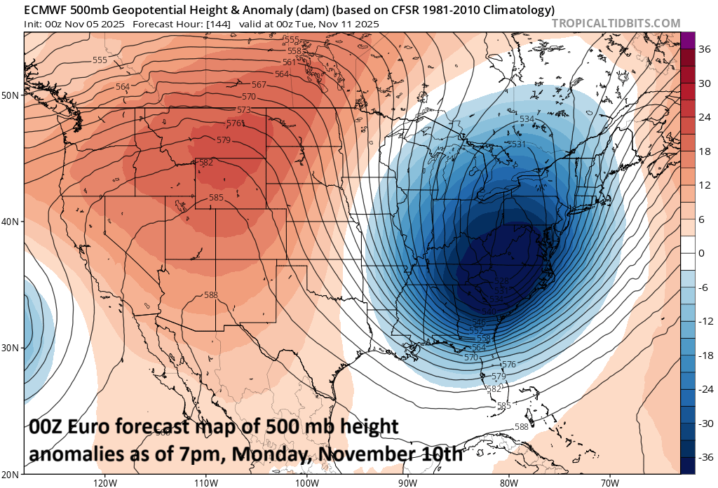
An intense upper-level low is likely to drop south and east early next week into the central Appalachians…the result will be a highly unstable atmosphere (and snow) across a large part of the eastern US. Map courtesy ECMWF, tropicaltidbits.com
Overview
An active weather pattern over the next several days will feature a powerful wind event on Wednesday night across many northeastern states and then an Arctic invasion will take place across the eastern states early next week with impacts being felt all the way from Florida-to-Maine. The powerful winds on Wednesday night will be associated with an intensifying low-pressure system that forms along a strong cold frontal boundary zone, and 50-60 mph wind gusts are on the table for the Mid-Atlantic region and Northeast US…some power outages are possible.
By the end of the upcoming weekend, another strong cold front will slide across the Great Lakes and into the eastern states, and this front will be at the leading edge of the coldest air mass of the season so far. Low pressure will develop along the frontal boundary zone, and it will be supported aloft by a vigorous low which will drop south and east into the central Appalachians. This combination of a strong surface low and a powerful upper-level low will ensure accumulating snow in many areas including the Great Lakes and interior sections of the Mid-Atlantic region and Northeast US. In fact, given the high levels of instability expected around here early next week, and the well below-normal temperatures, snow shower activity is certainly on the table all the way into the immediate I-95 corridor.
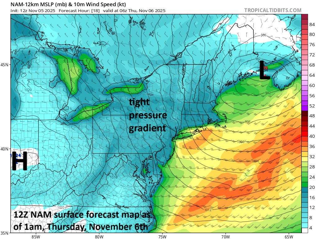
A powerful wind event is in store for much of the Mid-Atlantic region and Northeast US on Wednesday night associated with a strong cold front and intensifying low pressure. Wind gusts should reach the 50-60 mph range in many spots which raises a red flag for the potential of some power outages in the northeastern states. Map courtesy NOAA, tropicaltidbits.com
Powerful wind event on Wednesday night
After a breezy, mild day on Wednesday in the Mid-Atlantic/Northeast US, a strong cold front will slide across the region tonight and low pressure will intensify significantly along the frontal boundary zone over New England. The pressure difference between the intensifying low-pressure system over New England and an incoming high pressure over the Midwest will tighten dramatically later this evening. As a result, winds will increase in intensity and can gust to the 50-60 mph range in many sections of the northeastern part of the nation…some power outages are on the table. Winds will then begin to relax on Thursday morning as the high-pressure system gets closer to the region, and temperatures will struggle to get out of the 50’s in many of the same areas that reach well up into the 60’s on Wednesday.

Arctic air will invade the eastern US early next week likely resulting in well below-normal temperatures all the way from southern Florida-to-Maine. Map courtesy ECMWF, Weather Bell Analytics
Arctic blast early next week with impacts from Florida-to-Maine
Looking ahead, another strong cold front will be headed southeast on Sunday across the Great Lakes and likely will arrive in the northeastern states by early Sunday evening. This cold frontal system will be at the leading edge of an Arctic air mass that had its origins right near the North Pole. Temperatures will drop to well below normal levels on Monday and Tuesday all the way from southern Florida-to-Maine and many spots will experience their first hard freeze of the season on Monday night.

Even the Sunshine State will be impacted by this upcoming Arctic invasion with actual temperatures likely well down in the 40’s by Tuesday morning in southern sections of the state. Map courtesy ECMWF, Weather Bell Analytics
In terms of snowfall, a key player will be a vigorous upper-level low that will drop south and east to the central Appalachians, and this positioning ensures atmospheric instability over a large part of the eastern US. As a result, accumulating snow will be possible during this cold air outbreak from the Great Lakes to the interior sections of the Mid-Atlantic region, Northeast US, and New England. Furthermore, given the expected unstable environment in the DC-to-Philly-to-NYC corridor, snow showers are certainly on the table for the immediate I-95 corridor region as well as to the interior sections of the northeastern states.
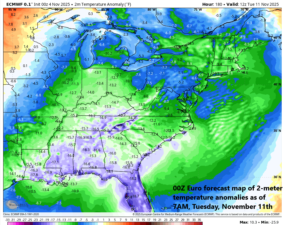
Arctic air will invade the eastern US early next week likely resulting in temperatures some ten to twenty degrees below-normal all the way from southern Florida-to-Maine. Map courtesy ECMWF, Weather Bell Analytics
Get ready…an active weather pattern brings potentially damaging winds on Wednesday night to many sections across the northeastern states, and the first taste of winter comes early next week across much of the eastern US with Arctic air extending all the way to Florida and accumulating snow in many areas.
Meteorologist Paul Dorian
Arcfield
arcfieldweather.com
Follow us on Facebook, Twitter, YouTube
Video discussion: