
***An Arctic invasion early next week featuring a vigorous upper-level low...first hard freeze, snow for many...impacts down to Florida...additional cold shots on the horizon northeastern states***
Paul Dorian

A key player in this early week Arctic air outbreak will be a vigorous upper-level low which will help to produce instability (and snow) across a large portion of the eastern US. Map courtesy ECMWF, Weather Bell Analytics
Overview
An Arctic air mass that had its origins right near the North Pole will invade the eastern US early next week and there will be impacts felt all the way down to Florida. This will be the coldest air mass so far this season and many spots in the eastern states will experience their first hard freeze of the fall. A vigorous upper-level low will accompany this Arctic blast causing widespread unstable conditions and the result will likely be accumulating snow across some of the higher elevation Appalachian Mountains, and just downstream of the Great Lakes in those usual “favored” areas. And given an expected widespread area of unstable conditions, snow showers are even on the table for the immediate I-95 corridor from later Monday into Monday night. Looking ahead, it doesn’t look like there will be any sustained warmup across the northeastern part of the nation following this early next Arctic air outbreak with additional cold shots to follow into mid-month.

An Arctic air outbreak this time of year will often lead to a significant Great Lakes snow event given the still relatively warm waters which helps to destabilize the lower atmosphere as cold air flows above. Map courtesy NOAA, Weather Bell Analytics
Details
A strong cold front will head southeast on Sunday across the Great Lakes and likely will push off the east coast on Sunday evening. This cold frontal system will be at the leading edge of an Arctic air mass that had its origins right near the North Pole many days ago. Temperatures will drop to well below normal levels early next week where many spots will experience their first hard freeze of the season on Monday night. The impact of this Arctic blast will be felt all the way down to Florida where Tuesday morning wind chills and low temperatures will be far below normal for this time of year.

Accumulating snow is likely during this early week Arctic air outbreak in, for example, the higher elevation locations of the Appalachians and just downstream of the Great Lakes in the usual “favored” locations. Map courtesy ECMWF, Pivotal Weather
In terms of snowfall, a key player will be a very vigorous upper-level low that will drop south and east to the central Appalachians by later Monday, and this positioning ensures atmospheric instability over a large portion of the eastern US. As a result, accumulating snow is quite likely during this cold air outbreak in higher elevations of the Appalachians (e.g., West Virginia, Kentucky, Tennessee, North Carolina). In addition, the Great Lakes “snow machine” will be turned on with accumulating snow in many of the usual “favored” areas just downstream such as western New York and western PA. In fact, this is a perfect setup for Great Lakes snow as the waters are still relatively warm and Arctic air flowing above will create highly unstable atmospheric conditions...and snow bands. Furthermore, given the expected unstable environment over a large area, snow showers will be possible all the way into the immediate I-95 corridor region from DC-to-Philly-to-NYC later Monday into Monday night.
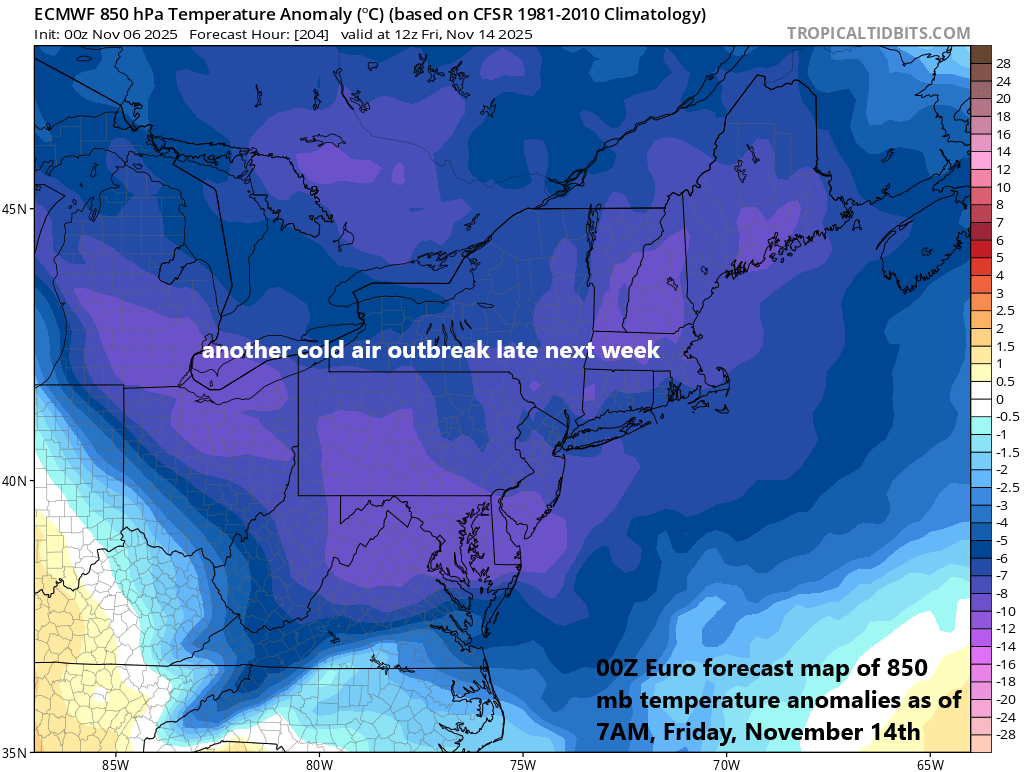
Talk of a sustained warmup in the northeastern part of the nation following this early week Arctic air outbreak are a bit premature. It looks like additional cold air shots are destined to reach the northeastern states from later next week into the middle of the month. Map courtesy ECMWF, tropicaltidbits.com
Looking ahead, there has been plenty of talk of a sustained warmup in the northeastern states following this Monday/Tuesday Arctic blast; however, I think that is overly optimistic. While there certainly will be some days with above-normal temperatures going forward, I see additional cold shots for the northeastern states from later next week into the middle of November.
Meteorologist Paul Dorian
Arcfield
arcfieldweather.com
Follow us on Facebook, Twitter, YouTube
Video discussion: