
****”Clippers” galore...Friday system weakens, but can produce snow in DC, VA...potential of accumulating snow this weekend in Mid-Atlantic with the most impressive system...a major Arctic blast****
Paul Dorian

The upper-level support will be “strong” for the “clipper” system that reaches the Mid-Atlantic region later in the weekend and it can produce some accumulating snow across the DC-to-Philly-to-NYC corridor. Map courtesy Canadian Met Centre, Pivotal Weather
Overview
The next several days will feature multiple “clipper” low pressure systems across the northern US which are typically rather quick movers from northwest-to-southeast. One such system will track well to the north and west of the DC-to-Philly-to-NYC corridor later today bringing windy and slightly milder conditions to the I-95 corridor along with the threat of a few rain showers. A second “clipper” system will push towards the Mid-Atlantic region on Friday from the Ohio Valley. While this system may begin to weaken upon its approach, it can still produce some snow on Friday in parts of the Mid-Atlantic region including the DC metro and parts of Virginia (a hot spot so far this winter season for snowfall).
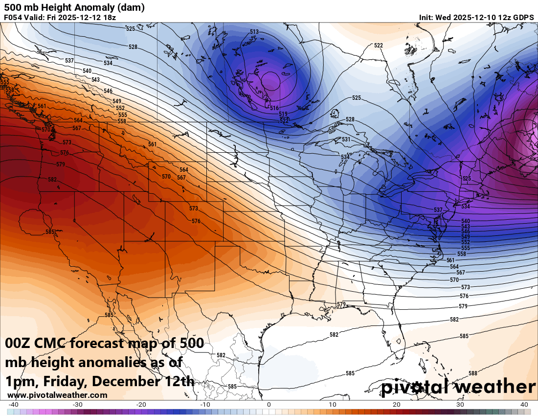
Over the weekend, yet another “clipper” system will push east-southeast towards the Mid-Atlantic region from the Ohio Valley, and this one will feature some strong support in the upper atmosphere with a vigorous jet streak. As a result, this is the most impressive to me of all of these “clipper” systems with the highest potential of producing accumulating snow in the Mid-Atlantic region (late Saturday into early Sunday). One final note, the Arctic blast that reaches the north-central US by early this weekend and then the Mid-Atlantic/Northeast US by early next week will feature some of the coldest air yet in this relentless cold weather pattern that began around Thanksgiving Day. Temperatures can drop to twenty degrees below zero by Sunday morning across a wide portion of the Upper Midwest from Minnesota-to-Iowa-to-Wisconsin.
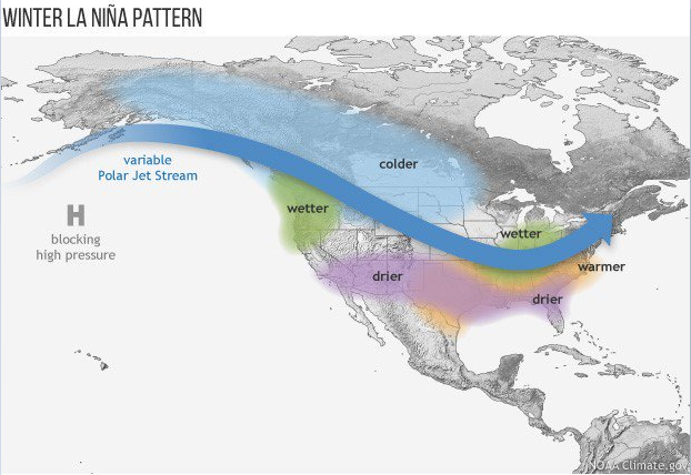
La Nina winters tend to feature a dominate polar jet stream and “clipper” low pressure systems frequently will ride along the upper-level wind flow from southwestern Canada to the Northeast US. Graphic courtesy NOAA
Details
Often during La Nina winters which we are currently experiencing (i.e., colder-than-normal water across the equatorial Pacific), the polar jet stream is more dominate than the sub-tropical branch and it typically extends from southwestern Canada to the Northern Plains and then to the northeastern states in the US. As such, low pressure systems will often ride along this wind field at a relatively fast clip from northwest-to-southeast and the next several days will feature multiple “clipper” low pressure systems in the northern US. These “clipper” systems can be limited in available moisture being far away from either the Pacific or Atlantic Oceans; however, they still can produce accumulating snow along their path given the right atmospheric conditions (i.e., if they can generate strong upward motion).
The upper-level support will be “moderate” for the “clipper” system on Friday as it reaches the Mid-Atlantic region…as a result, it will undergo some weakening, but can still produce some snow across DC and much of Virginia. Map courtesy Canadian Met Centre, Pivotal Weather
One “clipper” system will push well to the north and west of the I-95 corridor later today and the result will be an increasingly strong south-to-southwest flow of air from DC-to-Boston (gusts into the 30-40 mph range). This low-level flow will help to boost temperatures to the 40’s later today in the big cities and their surrounding suburbs and there can be occasional rain showers. In the higher elevation locations of the Mid-Atlantic and Northeast US, accumulating snow of up to a few inches is quite likely to include places like northern PA, western/northern NY, and interior New England. Very cold Arctic air will follow this low-pressure system on Wednesday night and Thursday with temperatures once again running at well below normal levels throughout the northeastern part of the country.
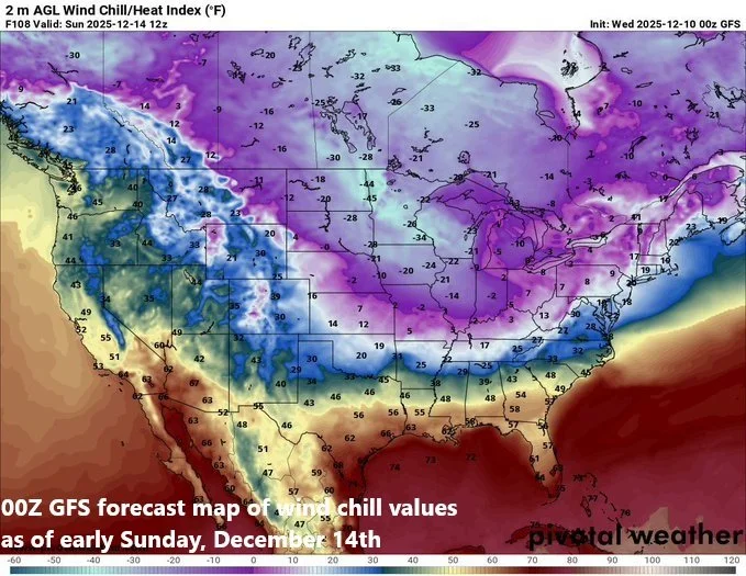
An Arctic air outbreak will reach the US by the early part of the weekend and the Northern Plains/Upper Midwest will suffer with bitter cold wind chill values by the early part of Sunday. Map courtesy Pivotal Weather, NOAA

This Arctic outbreak may produce the lowest temperatures so far in this ongoing cold weather pattern with departures from normal as high as forty degrees in some areas. Map courtesy ECMWF, Dr. Ryan Maue (X), weathermodels.com
On Friday, the next in a series of “clipper” systems will produce accumulating snow in the Ohio Valley and then head towards the Mid-Atlantic region. While this system is likely to lose some of its punch as it reaches the Mid-Atlantic region, it can produce some snow in portions of the area including the DC metro and parts of Virginia which has been a hot spot for snowfall so far this season. Chances of snow will be lower farther to the north and east in places like Philly and NYC given the expectation of the weakening of this system during the day on Friday...more cold air will follow as we enter the weekend.
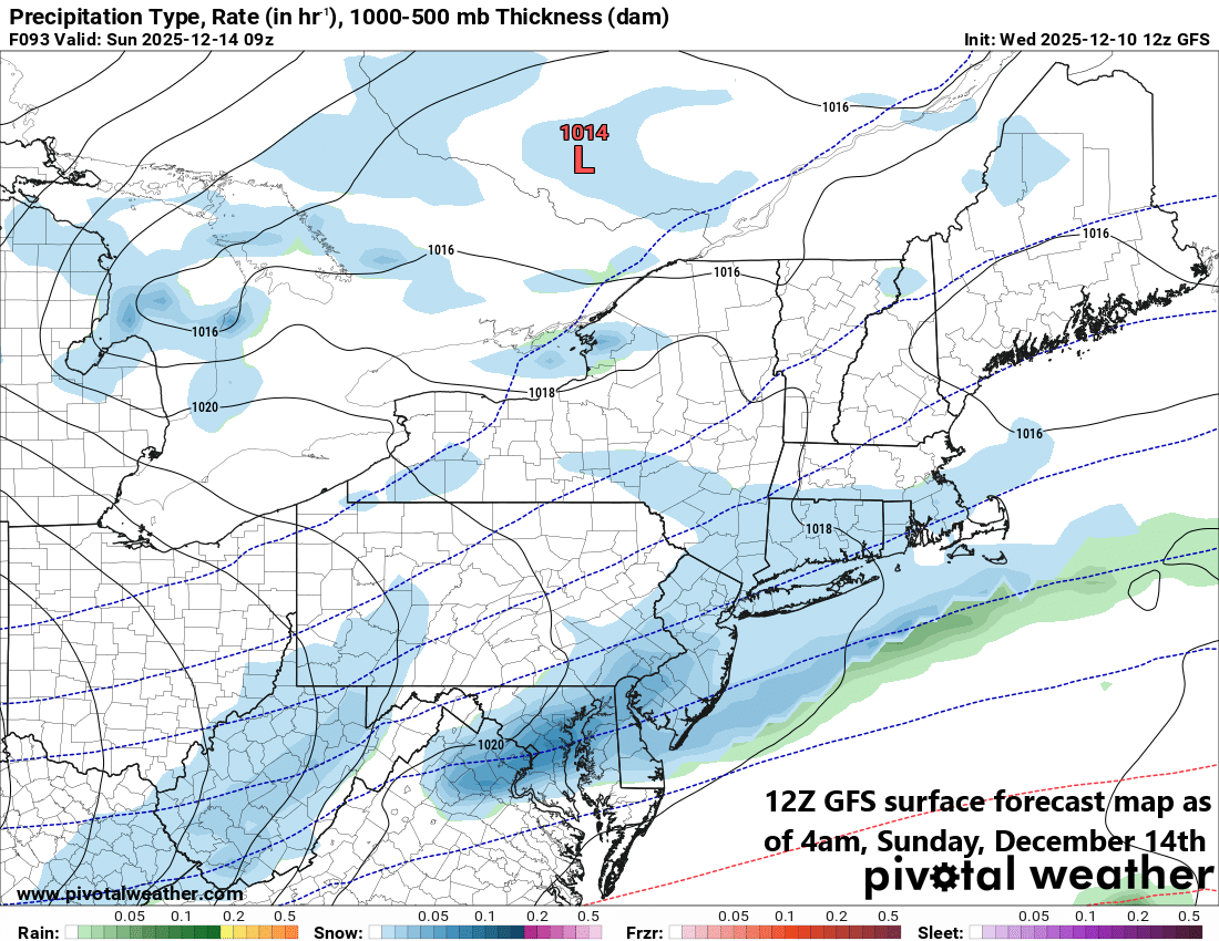
The third “clipper” system in a series of “clippers” - and the most impressive-looking to me - can produce accumulating snow in the DC-to-Philly-to-NYC corridor from late Saturday into early Sunday. This system will be followed by yet another Arctic air outbreak into the northeastern states for the late weekend and early part of next week. Map courtesy NOAA, Pivotal Weather
Over the weekend, yet another “clipper” system - and the one with the most potential in my opinion - will head in an east-to-southeast direction and produce accumulating snow along its path across much of the Midwest and Ohio Valley. When this system arrives in the Mid-Atlantic region late Saturday, it looks like it will have quite a bit of upper-level support; specifically, in terms of a powerful jet streak. This jet streak is likely to generate strong upward motion across the Mid-Atlantic region and Northeast US from late Saturday to early Sunday - assuring there is no weakening of this low-pressure similar to the Friday system - and the result can be accumulating snow in much of the Mid-Atlantic and Northeast US. And similar to the Arctic outbreak that will follow today’s “clipper”, an Arctic air mass will follow the weekend system into the northeastern states for the late weekend and early part of next week. Looking ahead, indeed there are signs for a warmup across the Mid-Atlantic region and Northeast US during the middle and latter parts of next week and we’ll monitor those prospects during the next few days.
Meteorologist Paul Dorian
Arcfield
arcfieldweather.com
Follow us on Facebook, Twitter, YouTube
Video discussion: