****Significant winter storm for the Mid-Atlantic...substantial icing for some areas...lowest temperature in Canada since 1999 was recorded on Monday...an important cold air source region****
Paul Dorian

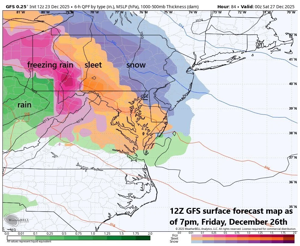
Lots of colors on a surface forecast map this time of year is not good as it suggest ice is in the mix…indeed, there is a significant winter storm threat for the Mid-Atlantic and NE US later Friday and Friday night with substantial snow (blue) likely in some areas and serious icing in others (sleet shown in orange, freezing rain shown in pink). Map courtesy ECMWF, Weather Bell Analytics
Overview
While the nation’s mid-section enjoys rarely ever-seen sustained warmth for the next few days, the northeastern states will continue to experience plenty of winter weather right into the early part of January. One system is bringing some accumulating snow today to the northern Mid-Atlantic region and Northeast US and some interior higher elevation locations will receive several inches. Another storm system is likely to threaten the Mid-Atlantic region and Northeast US on Friday with significant accumulating snow in some areas and substantial icing in others. A key player at the end of the week will be a strong high-pressure system over southeastern Canada which will act as an anchor for low-level Arctic air that can lead to frozen precipitation throughout the Mid-Atlantic region and Northeast US.
Looking ahead to next week, the winter weather pattern is likely to continue across the northeastern states with two major-league Arctic air outbreaks on the table. Both of these Arctic air masses will have originated up across the northwestern part of Canada where temperatures on Monday morning bottomed out at -67.7°F... reportedly the lowest temperature in Canada since January 1999…in other words, get ready, next week’s Arctic invasions might be quite noteworthy.
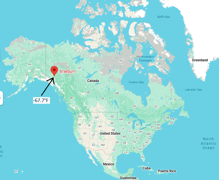
Braeburn, Yukon recorded a low temperature of -67.7°F on Monday morning - the lowest temperature in Canada since January 1999. The northwestern part of Canada is a critical cold air source region for the northern US…in fact, two Arctic air outbreaks destined to reach the Mid-Atlantic/Northeast US next week will have their origins in this same part of Canada where there has been extreme cold in recent days…in other words, get ready for potential noteworthy Arctic blasts. Map courtesy Google
Details
Snow is falling today across much of the northern Mid-Atlantic region and Northeast US as low pressure slides across the southern part of Canada and several inches can accumulate in some of the interior higher elevation locations (e.g., northern PA, southern NY). Snow will wind down across northern New England by later tonight and the mid-week will feature generally dry conditions and stiff NW winds on the backside of a trailing cold front in the northeastern part of the nation.
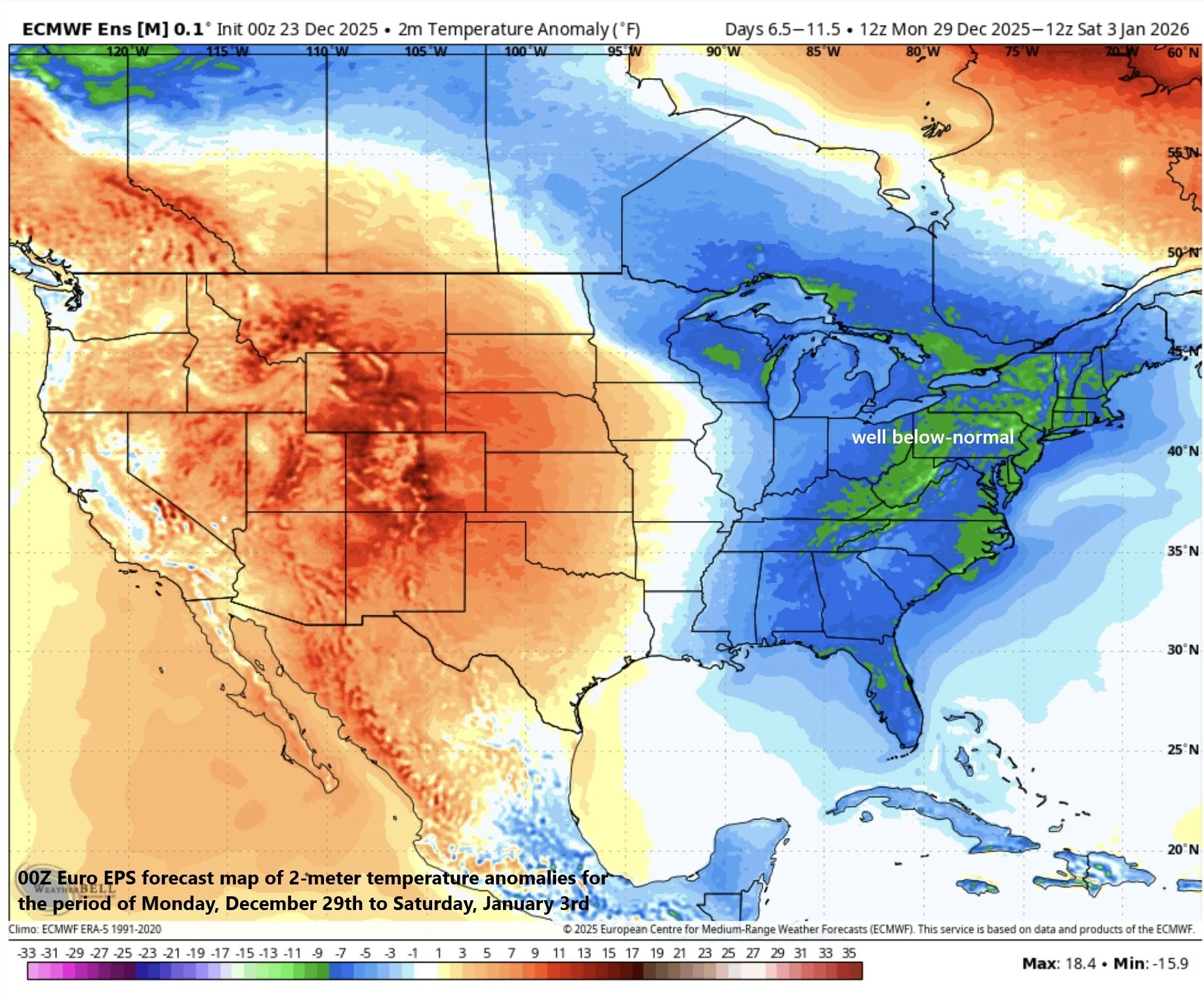
The period from Monday, December 29th to Saturday, January 3rd is likely to average out well below-normal for temperatures across the eastern US. Map courtesy ECMWF, Weather Bell Analytics
By later Thursday, strong high pressure will begin to move into the Hudson Bay region of Canada, and this system will become a crucial player in the late week winter storm event. This high will be positioned over southeastern Canada by the end of the week, and it will act as an anchor for a dense and cold Arctic air mass that will spill down into the northeastern part of the US. As such, the stage will be set for frozen precipitation from later Friday into Friday night with low-level Arctic air unlikely to give up any ground as moisture associated with low pressure expands in coverage across the Mid-Atlantic region and Northeast US. In those areas where the entire atmospheric column remains below freezing, substantial snow accumulations will be on the table (e.g., northern Mid-Atlantic/interior Northeast US). In other areas, where there can be below-freezing air at low levels of the atmosphere and slightly above-freezing air aloft, the result may be significant icing (e.g., southern Mid-Atlantic). It is too early to determine exactly who gets what from this late week storm system, but for now, we can say some areas will get substantial snowfall and other areas can get significant icing.
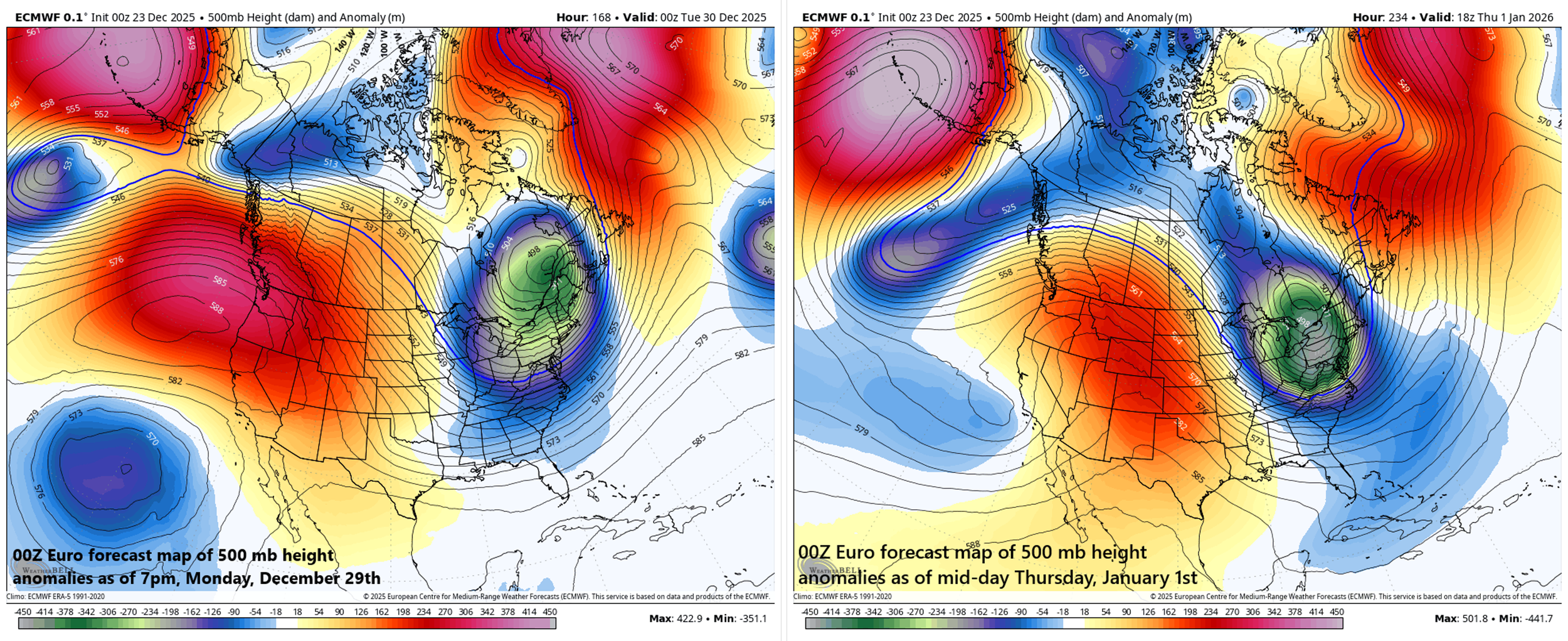
Two Arctic air outbreaks next week may be accompanied by deep troughs of low pressure in the upper part of the atmosphere (left map early next week; right map later next week). Maps courtesy ECMWF, Weather Bell Analytics
On the heels of the late week storm system, the upcoming weekend should start off on the chilly side in the Mid-Atlantic region and Northeast US. By the latter part of the weekend, yet another low-pressure system is going to push to the Great Lakes region, and its trailing cold front will slide towards the east coast. It might be too warm for frozen precipitation in much of the Mid-Atlantic region on Sunday, but snow and ice could certainly be a factor farther to the north across the Northeast US.
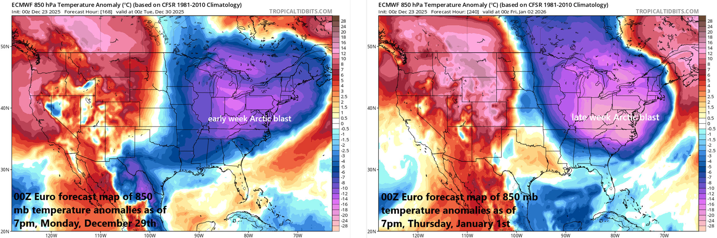
There may be two Arctic air outbreaks to deal with next week across the eastern US with one likely to arrive in the Monday/Tuesday time period (left forecast map) and a second by around Thursday, January 1st (right forecast map). Maps courtesy ECMWF, tropicaltidbits.com
Following the passage of the cold front, another Arctic air mass will flood the northeastern states, bringing well below-normal temperatures to the region for the first part of next week, and there can be snow shower activity just downstream of the Great Lakes. This early week Arctic air outbreak will have its origins up across the northwestern part of Canada and a second Arctic air outbreak is possible later next week with its origins in the same general area. It just so happens that temperatures bottomed out on Monday morning at -67.7°F in this particular region of northwestern Canada. The observation was recorded in Braeburn, Yukon and is reportedly the lowest temperature in Canada since January 1999. In other words, get ready...next week’s Arctic air outbreaks could be quite noteworthy.
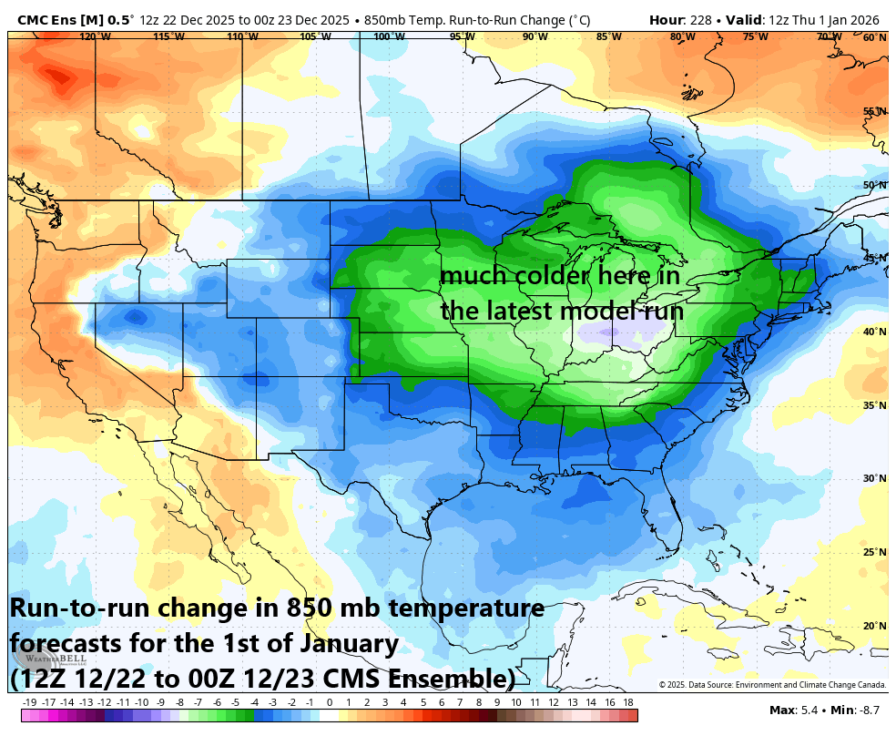
Computer forecast models continue to underestimate cold air outbreaks coming into the US when more than a few days in advance. This map is an example of a drastic “model-to-model” change in the forecasted 850 mb temperatures for the 1st day of January (i.e., next Thursday) with much colder conditions on the most recent run throughout much of the country compared to the prior run. Map courtesy Canadian Met Centre, Weather Bell Analytics
Meteorologist Paul Dorian
Arcfield
arcfieldweather.com
Follow us on Facebook, Twitter, YouTube
Video discussion: