***Multiple cold air outbreaks in an active pattern...light snow event likely across southern Mid-Atlantic on Friday...a possible east coast storm signal for down the road***
Paul Dorian

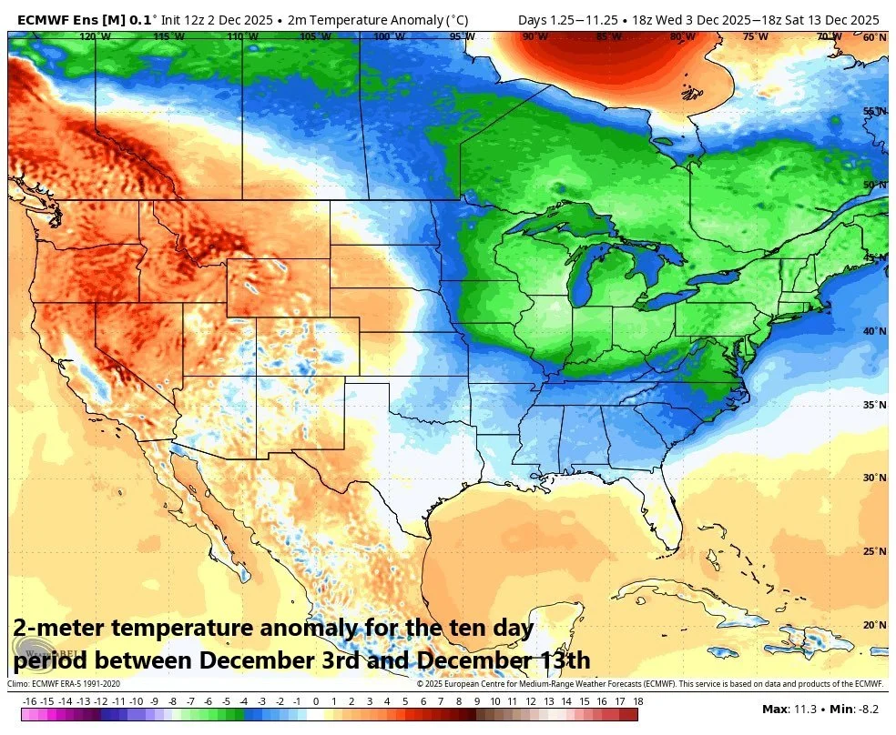
Additional cold air outbreaks in coming days assure colder-than-normal conditions on average for the ten-day time period from Wednesday, December 3rd to Saturday, December 13th. Map courtesy ECMWF, BAM Weather (X), Weather Bell Analytics
Overview
The month of December has gotten off to a cold start across much of the eastern half of the nation and there will be multiple cold air outbreaks in coming days. Two signals that have foreshadowed a cold period include an unusually early season stratospheric warming event and the movement of a tropical disturbance into a position that favors colder-than-normal weather across much of the nation. In fact, there appears to be a second burst of stratospheric warming in the offing for later this month resulting in a “stretched” polar vortex, and the tropical disturbance will likely persist in much of the same “cold” position” for awhile longer...both of these favor the idea of additional cold air outbreaks as we progress through the month.
The cold pattern has been quite active as well and multiple systems will have to be watched in coming days. On Friday, low pressure will develop over the Deep South and head in an northeasterly direction. This system is likely to produce some accumulating snow in the southern half of the Mid-Atlantic region and looks like a light-to-moderate snow event. Another low pressure system may pull out of the southeastern states by early next week and head in an northeasterly direction at the same time a “clipper” moves southeastward across the Great Lakes…we’ll monitor this activity as it could result in some accumulating snow for the northern Mid-Atlantic and Northeast US. Later next week, it appears a couple of other “clipper” systems will drop southeastward from southwestern Canada into the Great Lakes and ultimately, to the Northeast US. Finally, the significant change in recent days of an index value known as the “Southern Oscillation” is raising a red flag that the chance of an east coast storm will be on the rise somewhere down the road as the sub-tropical jet stream likely becomes activated.
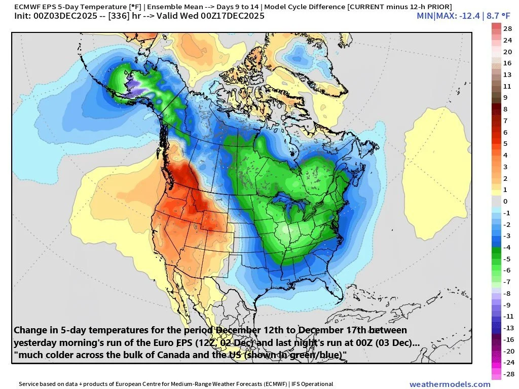
Computer forecast models continue to have trouble seeing the cold air outbreaks more than a few days in advance...this "delta" in temperatures is quite dramatic for the 5-day period of Dec 12-Dec 17 between yesterday morning's 12Z (02 Dec) Euro EPS model run and last night's 00Z (03 Dec) run...much colder trending for most of the US and Canada. Map courtesy BAM Weather (X), ECMWF, weathermodels.com
Near-term Arctic cold…numerous low temperature records may be broken on Thursday and Friday
Temperatures this morning across the northern states from Montana to Wisconsin are below-zero in many areas and this Arctic air mass will head southeast to the Mid-Atlantic region and Northeast US by later Thursday night and Friday. In fact, there may be numerous long-standing low temperature records set on Thursday and Friday across much of the region from the Upper Midwest to the Northeast US. Temperatures early Friday are likely to bottom out at the lowest levels of the season so far in the I-95 corridor with the middle or upper teens in many suburban locations from DC-to-Philly-to-NYC (single digits in and around Boston, MA). Daytime highs on Friday will be well below-normal for this time of year with the low-to-mid 30’s likely in DC, Philly, NYC as clouds thicken up (mid-to-upper 20’s in the Boston metro region).

There has been an unusually early Stratospheric Warming (SW) event across the polar region of the Northern Hemisphere and it appears quite likely for another “burst” of warming later in the month of December. This second SW event is a favorable sign for additional cold air outbreaks from Canada into the US as we progress through the latter stage of December and into January. Map courtesy NOAA, Weather Bell Analytics
Stratospheric Warming over the polar region…Madden-Julian Oscillation and tropical forcing
Two factors that have been pointing to an extended cold stretch this month include the unusually early stratospheric warming event that took place over the polar region of the Northern Hemisphere, and the movement of a tropical disturbance (MJO) to locations (or “phases”) which favor colder-than-normal weather in the eastern half of the nation. In fact, these two factors are “doubling-down” on their foreshadowing of colder-than-normal weather as we progress through December with a second burst of stratospheric warming likely later in the month resulting in a “stretched” polar vortex, and the rather persistent positioning of the tropical disturbance (MJO) in a cold “phase” 8 into the second half of December.

A tropical disturbance known as the Madden-Julian Oscillation (MJO) has moved into a cold location or “phase” 8 (left plot) in recent days and when this is combined with a weak La Nina - as we are currently experiencing - a 500 mb trough typically sets up across central Canada and the central US with “blocking” to the north over the polar region. Plot (left) of MJO courtesy NOAA, ECMWF; plot (right) of 500 mb height anomaly courtesy NOAA, BAM Weather
Late week snow threat for parts of the Mid-Atlantic
In terms of storms, the overall pattern has been quite active in recent days with a significant Great Lakes snow event late last week, a weekend snowstorm across the Midwest, and then an interior Mid-Atlantic/Northeast US snowstorm on Tuesday. All indications are that this active weather pattern will continue well into the month of December with several low pressure systems to monitor in coming days.
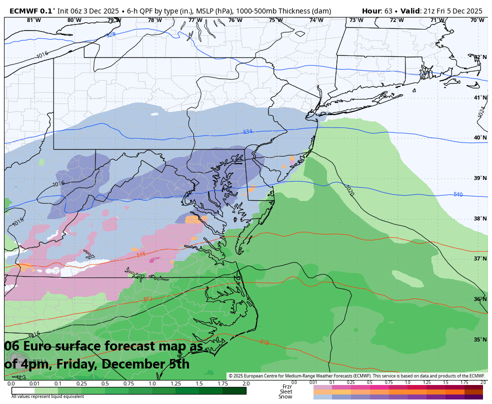
Low pressure could bring some accumulating snow to at least the southern portion of Mid-Atlantic region on Friday (i.e., southern/central Virginia, Delmarva Peninsula, DC metro, southern NJ), and perhaps as far north and east as Philly and NYC. Map courtesy ECMWF, Weather Bell Analytics
On Friday, low pressure and its moisture field will head northeast from the Tennessee Valley into the very cold (and dry) Arctic air mass that will be in place across the Mid-Atlantic region. Some accumulating snow is likely to break out early in the day across the southern Mid-Atlantic region from Virginia/DC to the Delmarva Peninsula and then it’ll reach the southern sections of New Jersey. Given the arrival time of early morning in the DC metro region, there certainly can be an impact on both the AM and PM commutes in the nation’s capital. The snow shield has a chance of extending north and east on Friday into the Philly and NYC metro regions, but those areas will be on the northern fringes.
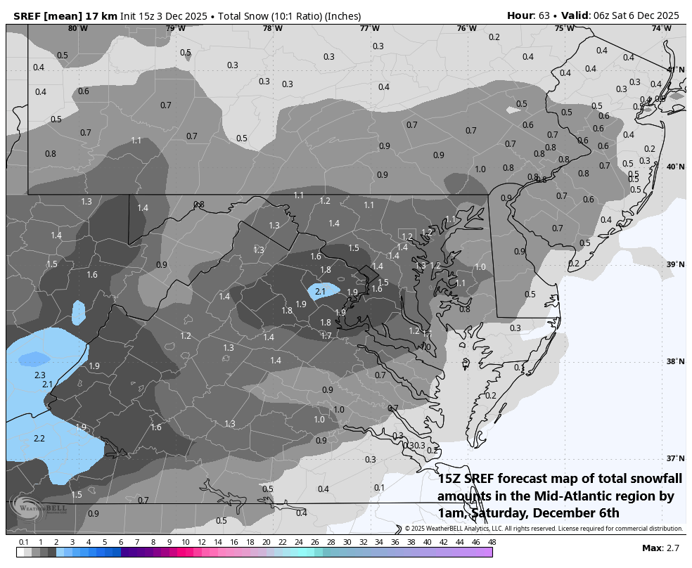
An accumulating snow event is on top for the southern Mid-Atlantic region on Friday extending from the DC/Virginia region to the Delmarva Peninsula to southern New Jersey. The Philly and NYC metro regions will be on the northern fringes of the low pressure system. Map courtesy NOAA, Tony Pann (X)
Looking ahead, another low pressure system may pull out of the Southeast US by early next week and it may combine with a “clipper” system moving across the Great Lakes…something to monitor next few days as it could result in some accumulating snow on Sunday night/early Monday in the northern Mid-Atlantic and Northeast US. Later next week, it looks like a couple of other “clipper” systems will drop southeastward out of western Canada and into the Great Lakes/Northeast US as the active weather pattern persists.
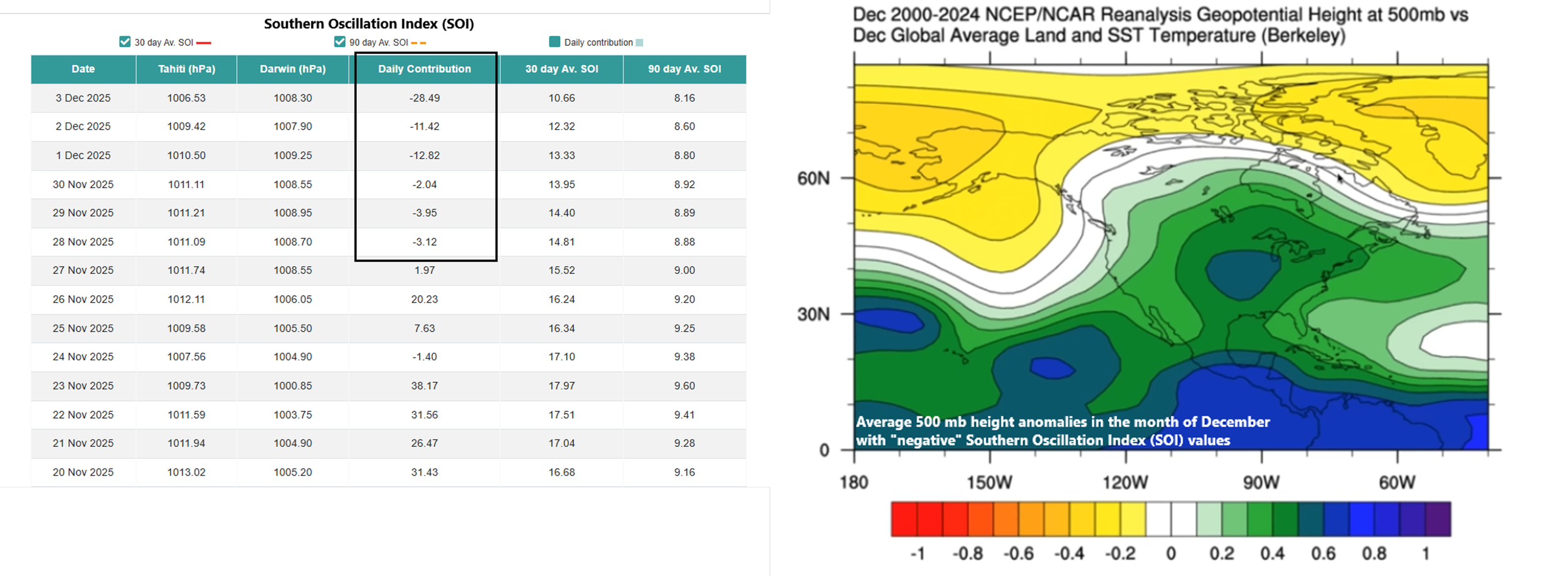
The Southern Oscillation Index (SOI) has dropped into “negative” territory in recent days (left table lists daily values) and in the month of December, this is usually associated with an upper-level trough over the central US (shown in blue/green) and “blocking” across Canada (shown in yellow). Table (left) courtesy Queensland Government Australia; Plot (right) courtesy NOAA, BAM Weather
Southern Oscillation Index and a possible east coast storm signal down the road
Another factor of interest that I am monitoring closely is known as the Southern Oscillation Index (SOI). This particular metric evaluates pressure differences in the Southern Hemisphere (specifically between Darwin, Australia and Tahiti) and it provides an assessment of the strength of the El Nino Southern Oscillation (ENSO) phenomenon be it El Nino (warmer than normal water) or La Nina (colder than normal water) which we are currently experiencing in the equatorial Pacific. When this index value falls into negative territory for a sustained period of time, it usually indicates El Nino is strengthening or, in this case, it suggests La Nina conditions are weakening across the tropical Pacific. The movement of the Southern Oscillation Index in recent days to deeper “negative” territory suggests to me that indeed La Nina is about to undergo some noticeable weakening, and this in turn, should activate the sub-tropical jet stream which, in turn, should raise the chance for an east coast storm system somewhere down the road...we’ll see how all of this plays out in coming weeks.
Meteorologist Paul Dorian
Arcfield
arcfieldweather.com
Follow us on Facebook, Twitter, YouTube
Video discussion: