
****Messy weekend with rain, strong winds…snow can precede the rain on Saturday with accumulations possible; especially, north of PA/MD border...a mid-week snow threat****
Paul Dorian

There is the threat of a major east coast storm next week that can have a big impact on the DC-to-Philly-to-NYC corridor in the later Wednesday/Thursday time frame. Map courtesy NOAA, tropicaltidbits.com
Overview
A major storm system that pounded the western US will cross the country and impact the northeastern states this weekend. There will be plenty of rainfall and strong winds during this weekend event in the Mid-Atlantic region, but snow and ice are likely at the onset with some accumulations possible on Saturday; especially, north of the PA/MD border. Once this system passes, cold air will pour into the northeastern states on powerful and potentially damaging NW winds and next week looks quite cold across much of the central and eastern US. Low pressure is likely to gather strength in the southern states by the middle of next week aided by an influx of Gulf moisture and it looks like it may become an accumulating snow threat by later Wednesday or Thursday.
Details
A strong storm system that has pounded the western US will cross the country and impact the eastern third of the nation this weekend bringing flooding rainfall on Saturday to some areas such as the Ohio and Tennessee Valleys and then significant accumulating snow to others on Sunday including interior New York State and New England.

The weekend will be quite a mess in the Mid-Atlantic region with plenty of rain and wind…snow is likely to precede the rain on Saturday with accumulations quite possible; especially, to the north of the PA/MD border. Map courtesy NOAA, tropicaltidbit.com
In the Mid-Atlantic region, the weekend weather event will range from cold and possible accumulating snow on the front-end to mild with plenty of rainfall and wind in the middle and back-end. All of this will be followed by an influx of very cold air on Sunday night and Monday and the first half of next week will be very cold across much of the nation including the Mid-Atlantic region. On Saturday, precipitation may begin as a quick thumping of snow and ice; especially, to the north of PA/MD border. Accumulations of a couple-to-a few inches are possible across eastern PA, central and northern New Jersey, and in the New York City metro area…likely from the mid-to-late morning hours to mid-afternoon. Farther to the south, the DC metro can experience some snow and/or sleet at the onset of the weekend event around mid-morning on Saturday with a coating or so possible; primarily, across the far northern suburbs. Later in the day, the precipitation will mix with and then changeover to rain and the rain will continue Saturday night and Sunday morning in the DC-to-Philly-to-NYC corridor. Some of the rain that falls on Saturday night and Sunday morning can be heavy at times and a strong thunderstorm cannot be ruled out. By later Sunday, strong low pressure to the north will drag a cold front through the region and temperatures are likely to plunge late Sunday/Sunday night from the mild levels achieved earlier in the day. Winds will become very strong behind the cold front from a northwesterly direction potentially gusting into the 50-60 mph range from later Sunday into the day on Monday…numerous power outages will unfortunately become a possibility.
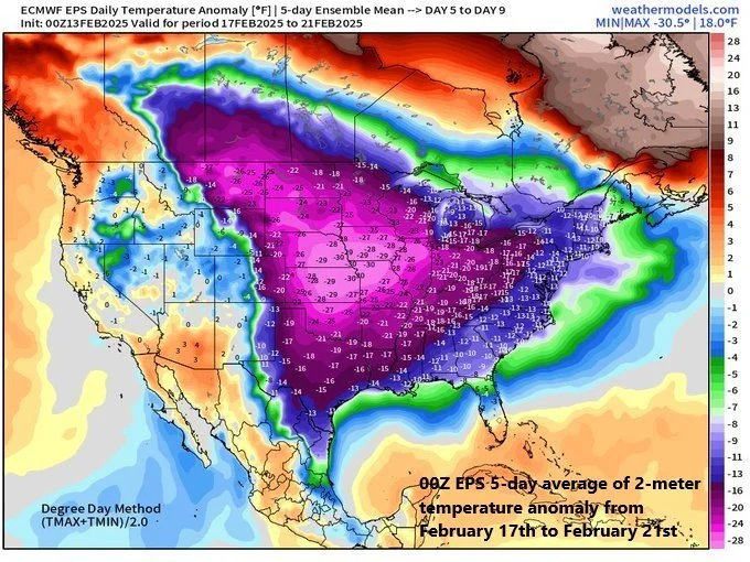
The first half of next week looks to be very cold across much of the central and eastern US with particularly cold air centered over the central states. By later Tuesday of next week, moisture will push northward into the Mississippi Valley resulting in snow to the north and rain down south. Low pressure over the northern Gulf region will then make a move to the northeast and head towards the Atlantic seaboard and it will encounter plenty of cold air across the Mid-Atlantic region. There are signs that this system will intensify significantly as it reaches the east coast…potentially becoming an important snow threat for the DC-to-Philly-to-NYC corridor in the later Wednesday/Thursday time frame...stay tuned.
Meteorologist Paul Dorian
Arcfield
arcfieldweather.com
Follow us on Facebook, Twitter, YouTube
Video discussion (Thursday):