
11:15 AM | *A “back and forth” temperature pattern likely to set the stage for multiple severe weather outbreaks during the month of March*
Paul Dorian
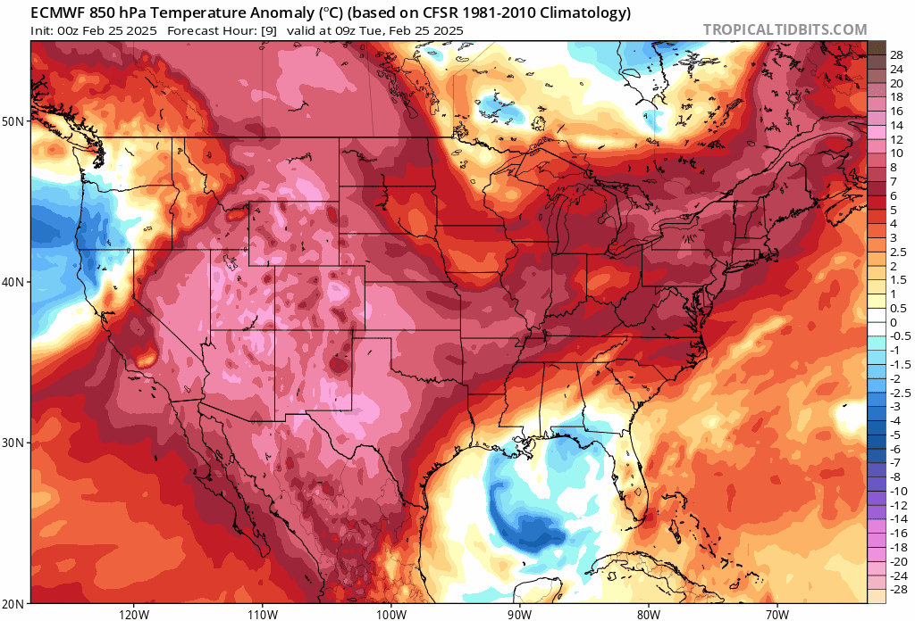
The next couple of weeks will feature a highly variable temperature pattern across the nation with cold air outbreaks intertwined with warm air surges. Maps courtesy ECMWF, tropicaltidbits.com
Overview
Today’s weather features above-normal temperatures across much of the nation and the remainder of the week will be generally on the mild side including in the Mid-Atlantic region where high temperatures of 60+ degrees will be commonplace. As nice as it may feel during the next few days, it appears likely that additional cold air outbreaks will make their way from Canada into the US during the next few weeks and this “back and forth” in temperatures could set the stage for multiple severe weather outbreaks during the month of March perhaps with a focus in the region from the Gulf coast to the Tennessee Valley. As the new month progresses, increasing strength of the sun will allow for warmer air masses to develop down across the southern states and any incoming cold air mass from Canada can produce “clash zones” with the prospects of severe weather. One such threat could take place next week somewhere in the middle of the nation with cold air from the north and west pushing towards warm, humid air to the south and east and there can be a repeat performance in the week to follow.

Spring fever hits a large part of the nation today with well above-normal temperatures in many areas. High temperatures in the DC-to-Philly-to-NYC corridor, as an example, can be well up in the 50’s and even near 60 degrees in some spots. Map courtesy NOAA, tropicaltidbits.com
Details
The month of March certainly carries with it the increasing chance of severe weather in the US with increasingly warm and humid air flowing northward from the Gulf region at the same time winter-like air masses drop south and east from Canada into the heartland. A “back and forth” type of temperature pattern is in the cards for the next few weeks with periodic cold air outbreaks making their way from Canada into the US and this variability can set the stage for multiple severe weather outbreaks. In some years, cold air overwhelms the overall weather pattern in the central and eastern states limiting the chance for severe weather outbreaks, but this may not be one of those more benign type of years.

An upper-level trough in the west combined with an upper-level ridge in the east can often set up a “battle zone” region in between the two systems leading to the possibility of severe weather. This type of scenario is on the table for the first full week of the month of March. Map courtesy ECMWF, tropicaltidbits.com
A red flag in the upper part of the atmosphere for the possibility of severe weather during the month of March is one that features an upper-level trough of low pressure across the western states and a ridge of high pressure in the east. The zone in between these upper-level features can often be “battle zone” areas with cold, dry air advancing from the north and west into warm and humid air that may be positioned to the south and east.

An upper-level trough in the west combined with an upper-level ridge in the east can often set up a “battle zone” region in between the two systems leading to the possibility of severe weather. This type of scenario is on the table for the second week of the month of March. Map courtesy ECMWF, tropicaltidbits.com
One such scenario is depicted for later next week and a similar setup is in the cards for the week to follow. It is way too early to discuss details including specific locations for possible severe weather during the next few weeks, but the overall pattern is shaping up to be quite active with a highly variable temperature pattern…stay tuned.

This particular forecast map of precipitation anomalies covers a 2-week period in March and features widespread wetter-than-normal conditions from the Mississippi Valley eastward to the Atlantic seaboard (and also across the western US). This anomaly forecast map certainly sends signals of an active weather pattern…indeed, one that can produce multiple severe weather threats. Map courtesy ECMWF, weathermodels.com (BAM Weather, X)
Meteorologist Paul Dorian
Arcfield
arcfieldweather.com
Follow us on Facebook, Twitter, YouTube
Video discussion: