
****An active February with multiple winter storms...mid-week ice threat in Mid-Atlantic...possible front end snow...back-end plain rain...similar scenario this weekend...snow threat next week****
Paul Dorian

Significant icing is possible in the Mid-Atlantic region from late Wednesday into early Thursday. This is a forecast map of “total freezing rain amounts” by the end of the mid-week event as depicted by the 12Z GEM. Map courtesy Canadian Met Centre, Pivotal Weather
Overview
February is now a few days old, and it looks like it will be a very active month with plenty of cold air around and it is likely to feature a polar vortex “split” and high-latitude blocking. There should be plenty of opportunities for snow, ice and rain in the Mid-Atlantic region as we progress through the month with just the next week or so likely to feature as many as three precipitation events. The first opportunity comes at mid-week, and it may turn out to be the first significant icing event in quite awhile for much of the Mid-Atlantic region with possible snow on the front end and plain rain on the back end. A similar scenario may take place this weekend with frozen precipitation possible on the front-end of the next storm system and plain rain on the back end. A third storm may threaten by the middle of next week and this one should have more cold air to work with raising the chance of accumulating snow in the Mid-Atlantic region.

The polar vortex is likely to “split” by the middle of the month with one piece centered over the Hudson Bay region of Canada and the other across the north pole. The positioning of one polar vortex over Canada is often correlated with a colder-than-normal pattern across the central and eastern US. Map courtesy ECMWF, Weather Bell Analytics
Polar vortex “split”...teleconnection index trends (AO, NAO, MJO)
If you like winter storms, then the next few weeks may be as good as it gets. The month of February is sure to be quite active with plenty of cold air around across the Canadian and US side of the pole. One of the features to watch in coming days will be the polar vortex as there are strong signs that this may “split” by the time we get to mid-month. As such, there can be a “piece” of the polar vortex centered over the Hudson Bay region of Canada by the middle of February. From this location, this part of the polar vortex can be an important cold air source region for the Mid-Atlantic and, in this particular case, can supply cold air from mid-February into March.
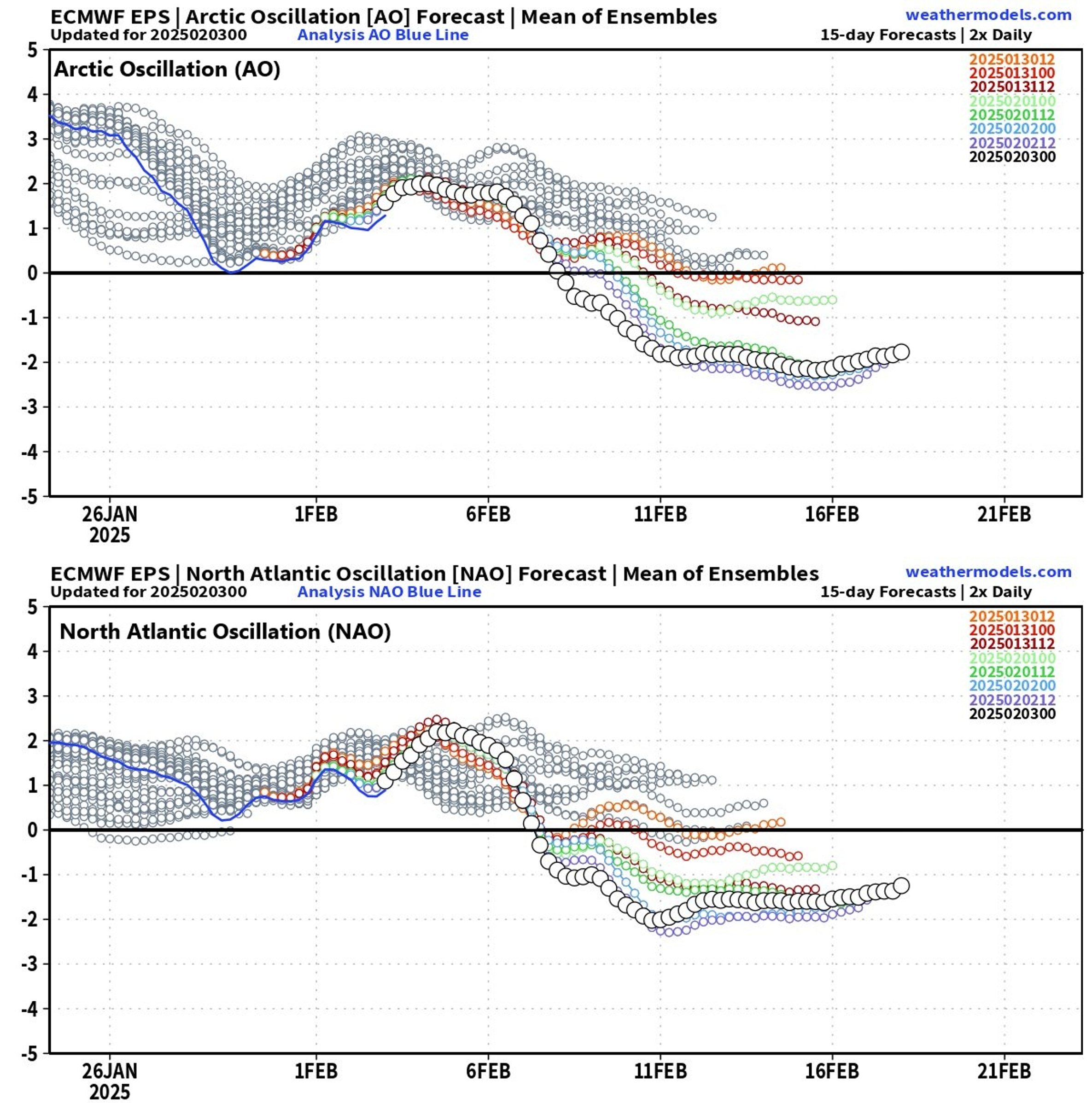
The teleconnection indices known as the AO (top) and NAO (bottom) are forecasted by the 00Z EPS to slip into “negative” territory for a sustained period of time beginning early next week and this is usually correlated with the development of “high-latitude blocking”, which, in turn, favors the transport of cold air masses from northern Canada into the central and eastern US. Plots courtesy ECMWF, weathermodels.com
Teleconnection indices also support the idea of a favorable pattern for cold air intrusions into the central and eastern states by mid-month as both the Arctic Oscillation (AO) and North Atlantic Oscillation (NAO) slip into “negative” territory for an extended period of time indicating that high-latitude blocking may become more prevalent. High-latitude blocking in the upper atmosphere tends to be a favorable setup for the transport of cold air masses from northern Canada into the central and eastern US.

The MJO is currently positioned in phase 5 (red dots) which is often a “warm” phase during this time of year in the central and eastern US. However, the tropical disturbance that is tracked by the MJO likely moves into the “cold” phases of 8, 1, and 2 by the middle of the month and these locations are typically quite favorable for cold air intrusions into the central and eastern US from Canada. Plot courtesy ECMWF
Another teleconnection index that is sending signals for cold air intrusions into the central and eastern US is the Madden-Julian Oscillation or MJO. The MJO tracks a tropical disturbance that propagates on a regular basis across the global tropics and - depending on its location or “phase” - it can contribute to colder-than-normal weather conditions across the central and eastern US. Indeed, the MJO appears to be headed through normally “warm” phases over the next several days; but from mid-month on, it is likely to push through “cold” phases for the central and eastern US enhancing the chances for cold air outbreaks from Canada into the US.
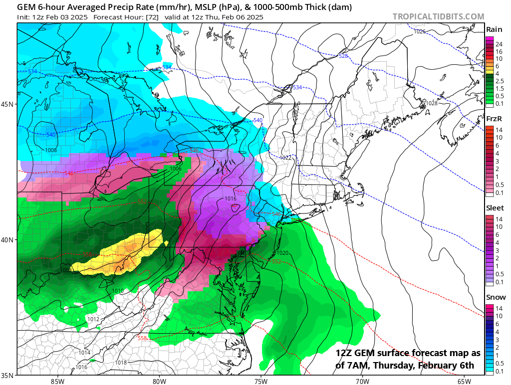
If there are lots of colors on the surface forecast map this time of year, it is usually not a good thing. Snow may take place at the front-end of the coming mid-week event (shown for this time in blue), but sleet (purple) and freezing rain (pink) is likely the bigger concern for the Mid-Atlantic region…icing threat likely in the late Wednesday to early Thursday time period. Map courtesy Canadian Met Centre, tropicaltidbits.com
Mid-week ice threat...possible snow at front-end...plain rain on back end
In just the next week or so, it appears there will be as many as three opportunities for snow, ice and rain in the Mid-Atlantic region. The first such opportunity will come at mid-week and this could turn out to be the most significant icing event in quite awhile for much of the Mid-Atlantic region leading to potential big-time issues for the Thursday AM commute in the DC-to-Philly-to-NYC corridor. The setup will include a cold frontal passage on Tuesday which will be followed by an influx of fresh cold and dry air on Tuesday night and Wednesday and at the same time moisture will gather over the Tennessee Valley. This dense, cold air mass will likely be quite reluctant to give up its ground on Wednesday as it will be anchored by strong high pressure centered over New England. As a result, surface temperatures may be slow to climb to above freezing levels in much of the Mid-Atlantic region during this mid-week event potentially leading to a situation that will feature an extended period of sleet and/or freezing rain. At the onset of the precipitation later Wednesday, there can be a period of snow…plain rain and above-freezing temperatures are very likely on the back end during the daytime hours on Thursday. It is, however, the “in-between” time on Wednesday night/early Thursday that is of greatest concern when there can be significant icing in at least many parts of the Mid-Atlantic region.
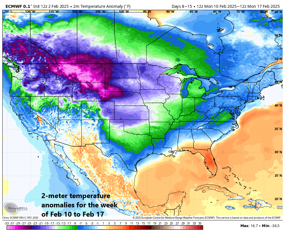
Numerous signs point to a colder-than-normal weather pattern by the middle of the month across much of the nation as depicted in this forecast map of 2-meter temperature anomalies that are averaged over the 7-day period from February 10th to February 17th. Map courtesy ECMWF, Weather Bell Analytics
Similar scenario possible this weekend with frozen precipitation possible followed by plain rain
Looking ahead, there have been rather persistent storm signals for a system this weekend which can have an impact on the Mid-Atlantic region in much the same manner as the mid-week event. Specifically, frozen precipitation will be possible on the front-end of the weekend system and then plain rain is likely on the back end. In fact, the overall setup will be quite similar with a cold frontal passage late in the week ushering in a fresh, cold and dry air mass for the beginning of the weekend and at the same time moisture will be gathering to our southwest. As a result, there can be some sleet and/or freezing rain later Saturday – possible preceded by snow in some areas – and this frozen precipitation will then likely change to plain rain and above-freezing temperatures on the back end of the storm system.
Snow threat by the middle of next week
After the weekend system passes by to the northeast of here at the end of the weekend, cold air is likely to push into the Mid-Atlantic region and - as many teleconnection indices are suggesting - this cold air intrusion may be able to penetrate farther to the south than prior ones. It appears that yet another storm system may then gather strength by the middle of next week in this ongoing active weather pattern and this one would likely have more cold air to work with compared to the prior two...all of which enhances the chance for accumulating snow in the Mid-Atlantic region. Stay tuned, next week’s threat is still several days away and just in the “speculation” phase for now.
Bottom line…if you like winter storms then the next few weeks may be as good as it gets. Indeed, February is looking like a very active month with lots of storm threats, plenty of cold air around, a polar vortex split, and high-latitude blocking.
Meteorologist Paul Dorian
Arcfield
arcfieldweather.com
Follow us on Facebook, Twitter, YouTube
Video discussion: