
****An intense storm system and a multi-day severe weather threat from the central US to the east coast****
Paul Dorian

This forecast map by the 12Z NAM high-resolution model of “Significant Tornado Parameter (STP)” is valid for 8PM, Saturday, March 15th. The STP is a composite index that shows areas were tornado formation is likely and the values depicted here are extremely elevated over the Mississippi/Alabama border region (max 15.5). Map courtesy NOAA, Weather Bell Analytics, James Spann (X)
Overview
Numerous ingredients are coming together for what is likely to be a multi-day severe weather event from the central US to the east coast during the period from later Friday to Sunday night. These ingredients include not just one, but two strong upper-level lows, powerful jet streaks at multiple levels of the atmosphere, an influx of warm, humid air on the storm’s front side, and a surface low pressure system that will deepen to rarely ever seen barometric pressure levels as it moves from the central Plains to the western Great Lakes. All severe weather parameters are on the table during this multi-day event including swaths of intense and damaging winds, strong tornadoes, hail, and torrential rainfall that can result in flash flooding. One final note, there will likely be blizzard conditions on Saturday/Saturday night in the cold sector of this intense storm system resulting in accumulating snow and wind gusts of up to 50 mph or so across western Minnesota and the eastern Dakotas.

The severe weather threat will be highest on Friday and Friday night across the Middle Mississippi Valley region where damaging wind gusts and strong tornadoes are on the table. Map courtesy NOAA/SPC
Multi-day severe weather event
Friday/Friday Night
On Friday, a strong storm system will intensify as it pushes northeast from the central Plains to the western Great Lakes. In fact, the central pressure of this surface low pressure system will likely drop to levels rarely ever seen in this part of the nation (perhaps to ~28.70 inches or 972 millibars) leading to a very strong pressure gradient...and likely a widespread area of intense and damaging winds on the order of 70+ mph in some spots. In addition, strong tornadoes can form later Friday and Friday night in a pattern that will feature both “supercell” thunderstorms and squall lines of strong-to-severe thunderstorms. One specific area of high concern for severe weather from later Friday afternoon to around midnight on Friday night will be the Middle Mississippi Valley region from central Illinois/southeastern Iowa to eastern Arkansas/northern Mississippi.

There will be two strong upper-level low pressures playing key roles in this upcoming multi-day severe weather event. The first pushes northeast from the central Plains to the western Great Lakes by late Friday night and the second system slides across the south-central states on Saturday. Map courtesy NOAA, tropicaltidbits.com
In the overnight hours, the main threat zone may shift to areas just to the south and east including portions of Mississippi, Alabama, and Tennessee. This system will be supported aloft by an intense upper-level low and powerful jet streaks at multiple levels of the atmosphere (100+ knots at 500 mb, 65+ knots at 850 mb). In addition, there will be a strong southerly flow of air on the front side of the system which will pump in very warm and humid air that will help to destabilize the atmosphere. The powerful surface low pressure system likely reaches the southern Minnesota region by early Saturday morning.
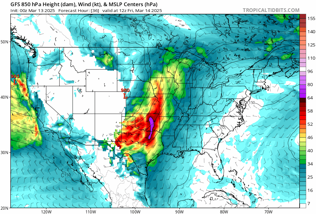
Powerful jet streaks at multiple levels of the atmosphere will play crucial roles in this upcoming multi-day severe weather event. This sequence of forecast maps by the 00z GFS depicts very strong winds at low-levels of the atmosphere (850 mb) in the period from Friday to Sunday. Maps courtesy NOAA, tropicaltidbits.com
Saturday/Saturday Night
On Saturday, with the initial upper-level low now over the western Great Lakes, an important new player on the field will be a second strong upper-level low that will barrel eastward across the south-central states and then turn northeast over the Tennessee Valley. This second strong system will too be accompanied by powerful jet streaks at multiple levels of the atmosphere and there will be an influx of warm, humid air on its front side. As a result, the atmosphere will become very unstable on Saturday across the Deep South, Tennessee Valley, and as far north as the Ohio Valley with severe weather expected across a large area.
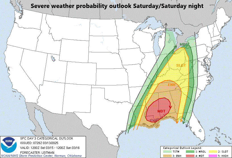
The severe weather threat shifts slightly to the east on Saturday and Saturday night with of focus of concern on the Deep South including the states of Louisiana, Mississippi, and Alabama. Map courtesy NOAA/SPC
One specific area of concern on Saturday and Saturday night will be the central Gulf coast region of eastern Louisiana, much of Mississippi, and Alabama where the threat of severe thunderstorms and strong tornadoes will be enhanced with a mix of “supercell” thunderstorms and squall lines. Another concern on Saturday and Saturday night will be for the possibility of torrential rainfall in portions of the Tennessee and Ohio Valleys which can lead to localized flash flooding conditions. One final note, there will likely be blizzard conditions on Saturday/Saturday night in the cold sector of this intense storm system resulting in accumulating snow and wind gusts of up to 50 mph or so across western Minnesota and the eastern Dakotas.
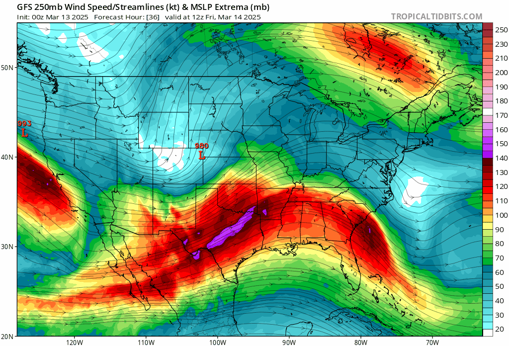
Powerful jet streaks at multiple levels of the atmosphere will play crucial roles in this upcoming multi-day severe weather event. This sequence of forecast maps by the 00z GFS depicts very strong winds at high-levels of the atmosphere (250 mb) in the period from Friday to Sunday. Maps courtesy NOAA, tropicaltidbits.com
Sunday/Sunday Night
By Sunday, the strong storm system will shift east to the eastern states and there will again be a strong southerly flow of low-level air out ahead of the system pumping very mild and moist air from south-to-north up along the eastern seaboard. In fact, it may feel downright humid on Sunday across the Mid-Atlantic and southward to the Carolinas as dew points potentially climb into the 60’s which may be for the first time this season in many areas. As a result, there can be some very heavy rainfall on Sunday in much of the eastern US and the threat of strong-to-severe thunderstorms will be on the table as a strong cold front barrels eastward from the Ohio Valley. The greatest risks of severe weather on Sunday/Sunday night will be for torrential downpours and damaging wind gusts although tornadoes are certainly on the table; especially, from the southern Mid-Atlantic region southward to the Carolinas. Cooler air will follow the passage of the cold frontal system into the eastern states for the beginning of next week, but – as is increasingly common for this time of year – the cool down will be rather short-lived and it should get very mild again by the middle of next week.
Meteorologist Paul Dorian
Arcfield
arcfieldweather.com
Follow us on Facebook, Twitter, YouTube
Video discussion: